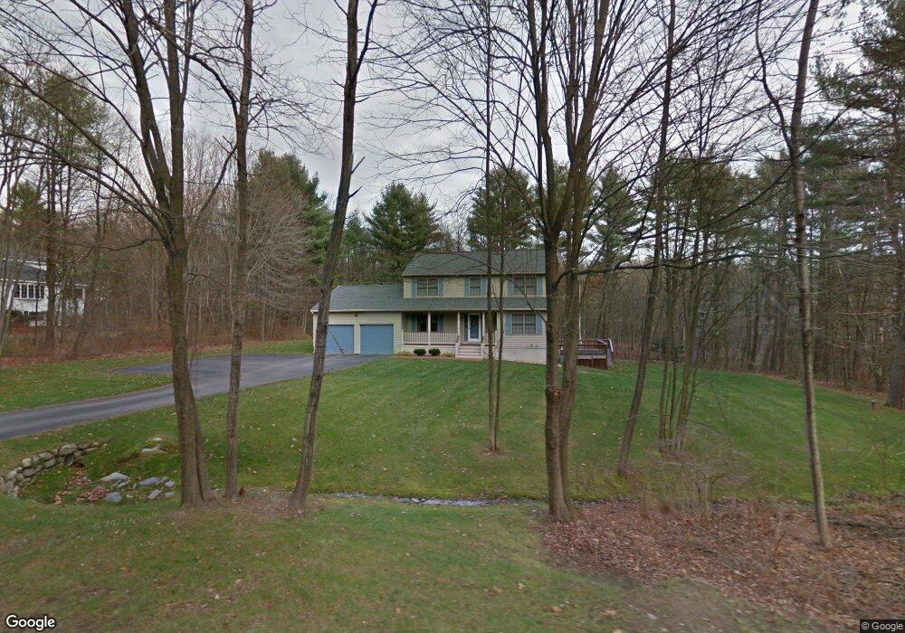
30 Catamount Rd Goffstown, NH 03045
Estimated Value: $540,433 - $643,000
3
Beds
2
Baths
1,932
Sq Ft
$310/Sq Ft
Est. Value
About This Home
This home is located at 30 Catamount Rd, Goffstown, NH 03045 and is currently estimated at $598,858, approximately $309 per square foot. 30 Catamount Rd is a home with nearby schools including Mountain View Middle School, Goffstown High School, and Polaris Charter School.
Ownership History
Date
Name
Owned For
Owner Type
Purchase Details
Closed on
Feb 22, 2012
Sold by
Lepagew Ronald L and Lepage Donna L
Bought by
Lepage Ft and Lepage Ronald L
Current Estimated Value
Purchase Details
Closed on
Nov 25, 1997
Sold by
Grenier Steven P
Bought by
Lepage Ronald L and Lepage Donna L
Home Financials for this Owner
Home Financials are based on the most recent Mortgage that was taken out on this home.
Original Mortgage
$60,000
Interest Rate
7.17%
Create a Home Valuation Report for This Property
The Home Valuation Report is an in-depth analysis detailing your home's value as well as a comparison with similar homes in the area
Home Values in the Area
Average Home Value in this Area
Purchase History
| Date | Buyer | Sale Price | Title Company |
|---|---|---|---|
| Lepage Ft | -- | -- | |
| Lepage Ronald L | $149,900 | -- |
Source: Public Records
Mortgage History
| Date | Status | Borrower | Loan Amount |
|---|---|---|---|
| Previous Owner | Lepage Ronald L | $60,000 |
Source: Public Records
Tax History
| Year | Tax Paid | Tax Assessment Tax Assessment Total Assessment is a certain percentage of the fair market value that is determined by local assessors to be the total taxable value of land and additions on the property. | Land | Improvement |
|---|---|---|---|---|
| 2025 | $9,770 | $467,900 | $188,400 | $279,500 |
| 2024 | $9,564 | $467,900 | $188,400 | $279,500 |
| 2023 | $8,825 | $467,900 | $188,400 | $279,500 |
| 2022 | $8,132 | $309,100 | $124,200 | $184,900 |
| 2021 | $7,672 | $309,100 | $124,200 | $184,900 |
| 2020 | $26 | $309,100 | $124,200 | $184,900 |
| 2019 | $7,598 | $309,100 | $124,200 | $184,900 |
| 2018 | $5,749 | $309,100 | $124,200 | $184,900 |
| 2017 | $7,228 | $263,600 | $102,800 | $160,800 |
| 2016 | $23 | $263,600 | $102,800 | $160,800 |
| 2015 | $7,099 | $252,100 | $96,700 | $155,400 |
| 2014 | $6,804 | $252,000 | $96,700 | $155,300 |
Source: Public Records
Map
Nearby Homes
- 73 River Ledge Dr
- 19 My Way
- 179 Donald Dr
- 11 E Dunbarton Rd
- 6 Mustang Ct
- 11-1 Chatel Rd
- 77 Straw Rd
- 5B Dearborn Cir
- 3B Dearborn Cir
- 3A Dearborn Cir
- 4C Dearborn Cir
- 0 Mast Rd Unit 49 5054665
- 2 Shore Dr
- 3 Timberwood Dr Unit 301
- 89 Moose Club Park Rd
- 55 Forestedge Way
- 25 Forestedge Way Unit 25
- 264 Woodview Way
- 237 Woodview Way
- 211 Woodview Way
- 34 Catamount Rd
- 27 Catamount Rd
- 35 Catamount Rd
- 21 Catamount Rd
- 15 Catamount Rd
- 30 Durango Dr
- 39 Catamount Rd
- 52 Durango Dr
- 42 Catamount Rd
- 10 Catamount Rd
- 41 Catamount Rd
- 20 Durango Dr
- 161 Goffstown Back Rd
- 12 Durango Dr
- 4 Durango Dr
- 54 Durango Dr
- 67 Durango Dr
- 5 Catamount Rd
- 18 Durango Dr
- 43A Durango Dr
Your Personal Tour Guide
Ask me questions while you tour the home.