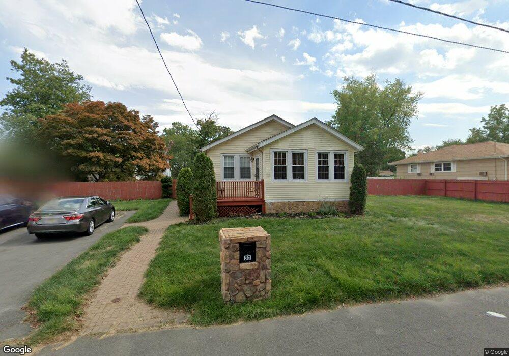
30 Ormond Ave Ewing, NJ 08638
Braeburn Heights NeighborhoodEstimated Value: $247,535 - $326,000
Studio
--
Bath
1,104
Sq Ft
$268/Sq Ft
Est. Value
About This Home
This home is located at 30 Ormond Ave, Ewing, NJ 08638 and is currently estimated at $296,384, approximately $268 per square foot. 30 Ormond Ave is a home located in Mercer County with nearby schools including Ewing High School, Paul Robeson Charter School For The Humanities, and Trenton Stem-To-Civics Charter School.
Ownership History
Date
Name
Owned For
Owner Type
Purchase Details
Closed on
Aug 18, 2005
Sold by
Waldron Peter
Bought by
Brown David and Brown Maureen
Current Estimated Value
Home Financials for this Owner
Home Financials are based on the most recent Mortgage that was taken out on this home.
Original Mortgage
$142,860
Interest Rate
5.79%
Purchase Details
Closed on
Aug 15, 2005
Sold by
Rivera Miriam
Bought by
Waldron Peter
Home Financials for this Owner
Home Financials are based on the most recent Mortgage that was taken out on this home.
Original Mortgage
$142,860
Interest Rate
5.79%
Purchase Details
Closed on
Aug 12, 2005
Sold by
Rivera George
Bought by
Waldron Peter
Home Financials for this Owner
Home Financials are based on the most recent Mortgage that was taken out on this home.
Original Mortgage
$142,860
Interest Rate
5.79%
Create a Home Valuation Report for This Property
The Home Valuation Report is an in-depth analysis detailing your home's value as well as a comparison with similar homes in the area
Home Values in the Area
Average Home Value in this Area
Purchase History
| Date | Buyer | Sale Price | Title Company |
|---|---|---|---|
| Brown David | $90,000 | -- | |
| Waldron Peter | $48,000 | -- | |
| Waldron Peter | $48,000 | -- |
Source: Public Records
Mortgage History
| Date | Status | Borrower | Loan Amount |
|---|---|---|---|
| Previous Owner | Brown David | $142,860 |
Source: Public Records
Tax History
| Year | Tax Paid | Tax Assessment Tax Assessment Total Assessment is a certain percentage of the fair market value that is determined by local assessors to be the total taxable value of land and additions on the property. | Land | Improvement |
|---|---|---|---|---|
| 2025 | $5,424 | $137,900 | $55,600 | $82,300 |
| 2024 | $5,098 | $137,900 | $55,600 | $82,300 |
Source: Public Records
Map
Nearby Homes
- 32 Ormond Ave
- 26 Ormond Ave
- 140 Hawthorne Ave
- 130 Hawthorne Ave
- 1 Loring Ave
- 18 Browning Ave
- 36 Browning Ave
- 142 Hawthorne Ave
- 31 Ormond Ave
- 16 Browning Ave
- 40 Browning Ave
- 7 Loring Ave
- 126 Hawthorne Ave
- 124 LOT 2 Hawthorne Ave
- 124 LOT 1 Hawthorne Ave
- 124 Hawthorne Ave Unit 124
- 124 Hawthorne Ave Unit 2
- 124 Hawthorne Ave Unit 1
- 137 Hawthorne Ave
- 193 Buttonwood Dr
Your Personal Tour Guide
Ask me questions while you tour the home.