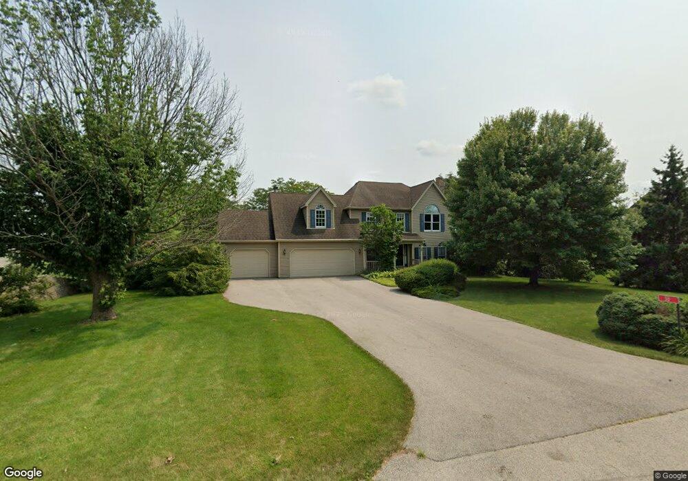
30 Red Hawk Dr Oswego, IL 60543
South Oswego NeighborhoodEstimated Value: $590,000 - $652,000
4
Beds
3
Baths
2,876
Sq Ft
$216/Sq Ft
Est. Value
About This Home
This home is located at 30 Red Hawk Dr, Oswego, IL 60543 and is currently estimated at $620,615, approximately $215 per square foot. 30 Red Hawk Dr is a home located in Kendall County with nearby schools including Grande Park Elementary School, Murphy Junior High School, and Oswego East High School.
Ownership History
Date
Name
Owned For
Owner Type
Purchase Details
Closed on
Jan 2, 2014
Sold by
Torgerson Duane E and Torgerson Elizabeth A
Bought by
Torgerson Duane E
Current Estimated Value
Purchase Details
Closed on
Jun 30, 2005
Sold by
Danna Philip F and Danna Elizabeth A
Bought by
Torgerson Duane E and Torgerson Elizabeth A
Home Financials for this Owner
Home Financials are based on the most recent Mortgage that was taken out on this home.
Original Mortgage
$105,000
Outstanding Balance
$54,917
Interest Rate
5.69%
Mortgage Type
Fannie Mae Freddie Mac
Estimated Equity
$565,698
Create a Home Valuation Report for This Property
The Home Valuation Report is an in-depth analysis detailing your home's value as well as a comparison with similar homes in the area
Home Values in the Area
Average Home Value in this Area
Purchase History
| Date | Buyer | Sale Price | Title Company |
|---|---|---|---|
| Torgerson Duane E | -- | None Available | |
| Torgerson Duane E | $455,000 | First American Title |
Source: Public Records
Mortgage History
| Date | Status | Borrower | Loan Amount |
|---|---|---|---|
| Open | Torgerson Duane E | $105,000 |
Source: Public Records
Tax History
| Year | Tax Paid | Tax Assessment Tax Assessment Total Assessment is a certain percentage of the fair market value that is determined by local assessors to be the total taxable value of land and additions on the property. | Land | Improvement |
|---|---|---|---|---|
| 2024 | $12,647 | $170,774 | $32,596 | $138,178 |
| 2023 | $11,463 | $151,127 | $28,846 | $122,281 |
| 2022 | $11,463 | $139,932 | $26,709 | $113,223 |
| 2021 | $11,880 | $139,932 | $26,709 | $113,223 |
| 2020 | $11,619 | $135,856 | $25,931 | $109,925 |
| 2019 | $11,406 | $131,629 | $25,931 | $105,698 |
| 2018 | $11,491 | $128,670 | $25,348 | $103,322 |
| 2017 | $11,392 | $123,721 | $24,373 | $99,348 |
| 2016 | $11,181 | $120,117 | $23,663 | $96,454 |
| 2015 | $11,002 | $113,318 | $22,324 | $90,994 |
| 2014 | -- | $108,959 | $21,465 | $87,494 |
| 2013 | -- | $110,060 | $21,682 | $88,378 |
Source: Public Records
Map
Nearby Homes
- 870 Simons Rd
- 27100 Timber Wood Ct
- 13005 Timber Wood Cir
- 13006 Timber Wood Cir
- 12704 Wild Rye Ct Unit 5B
- 27016 Thornwood Blvd
- 1813 Winchester Ct
- 601 Ironwood Ave
- 739 Juniper St
- 2253 Barbera Rd
- 6115 Rt 34
- 26918 Summergrove Dr
- 12922 Grande Poplar Cir
- 26613 Silverleaf Dr
- 12814 Grande Poplar Cir
- 26537 W Countryside Ln
- 100 acres Cherry Rd
- 12601 S Poplar Crossing
- 204 Amherst Cir
- 27009 Ashgate Crossing
Your Personal Tour Guide
Ask me questions while you tour the home.