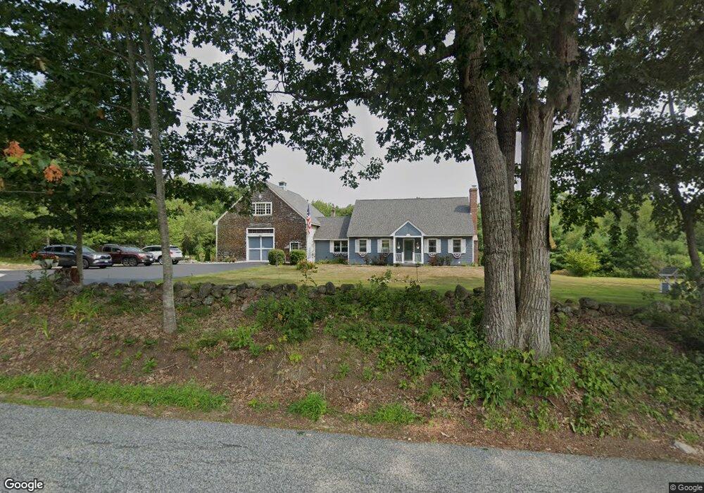
30 Sawyer Rd Ossipee, NH 03864
Estimated Value: $514,000 - $603,517
3
Beds
3
Baths
2,668
Sq Ft
$211/Sq Ft
Est. Value
About This Home
This home is located at 30 Sawyer Rd, Ossipee, NH 03864 and is currently estimated at $562,629, approximately $210 per square foot. 30 Sawyer Rd is a home located in Carroll County with nearby schools including Ossipee Central School, Kingswood Regional Middle School, and Kingswood Regional High School.
Ownership History
Date
Name
Owned For
Owner Type
Purchase Details
Closed on
Sep 29, 2006
Sold by
Bethel James O
Bought by
Tomasello Michael L and Tomasello Amy L
Current Estimated Value
Home Financials for this Owner
Home Financials are based on the most recent Mortgage that was taken out on this home.
Original Mortgage
$240,000
Interest Rate
6.52%
Mortgage Type
Purchase Money Mortgage
Create a Home Valuation Report for This Property
The Home Valuation Report is an in-depth analysis detailing your home's value as well as a comparison with similar homes in the area
Home Values in the Area
Average Home Value in this Area
Purchase History
| Date | Buyer | Sale Price | Title Company |
|---|---|---|---|
| Tomasello Michael L | $300,000 | -- |
Source: Public Records
Mortgage History
| Date | Status | Borrower | Loan Amount |
|---|---|---|---|
| Open | Tomasello Michael L | $285,800 | |
| Closed | Tomasello Michael L | $240,000 |
Source: Public Records
Tax History Compared to Growth
Tax History
| Year | Tax Paid | Tax Assessment Tax Assessment Total Assessment is a certain percentage of the fair market value that is determined by local assessors to be the total taxable value of land and additions on the property. | Land | Improvement |
|---|---|---|---|---|
| 2024 | $5,708 | $492,100 | $169,600 | $322,500 |
| 2023 | $5,160 | $497,600 | $175,100 | $322,500 |
| 2022 | $4,931 | $268,300 | $57,400 | $210,900 |
| 2021 | $4,925 | $268,700 | $57,400 | $211,300 |
| 2020 | $4,581 | $268,700 | $57,400 | $211,300 |
| 2019 | $4,597 | $268,700 | $57,400 | $211,300 |
| 2018 | $4,622 | $222,200 | $42,900 | $179,300 |
| 2016 | $4,308 | $223,200 | $42,900 | $180,300 |
| 2015 | $4,091 | $223,200 | $42,900 | $180,300 |
| 2014 | $4,422 | $245,400 | $56,100 | $189,300 |
| 2013 | $4,240 | $243,800 | $56,100 | $187,700 |
Source: Public Records
Map
Nearby Homes
- 123 Mountain Rd
- 179 Chickville Rd
- 132 Hanson Rd
- 190 Ledge Hill Rd
- 44 Valley Rd
- 41 Valley Rd
- 0 Ledge Hill Rd Unit 7
- 175 Mountain Rd
- Lot 4 Ridge Field Rd Unit 4
- 140 Chickville Rd
- 13 Ridge Field Rd
- 24 Ridge Field Rd
- 61 Dame Rd
- 6 Twin Cottage Ln
- Lot 25 Ridge Field Rd
- 16 Pollys Crossing Rd
- Lot 4 Vere Royce Rd
- 23 Ledge Hill Rd
- 51 Federal Corner Rd
- 1235 Center St
- 29 Sawyer Rd
- 31 Sawyer Rd
- 64 Sawyer Rd
- 21 Sawyer Rd
- 5 Millwood Rd
- 26 Sawyer Rd
- 40 Sawyer Rd
- 28 S Sawyer Rd
- 0 Sawyer Rd Unit 4692795
- 0 Sawyer Rd Unit 4691137
- 54 Sawyer Rd
- 44 Sawyer Rd
- 69 Phineas Graves Rd
- 41 Sawyer Rd
- 41 Shore Rd
- 47 Sawyer Rd
- 49 Sawyer Rd
- 57 Phineas Graves Rd
- 24 Sawyer Rd
- 15 Sawyer Rd