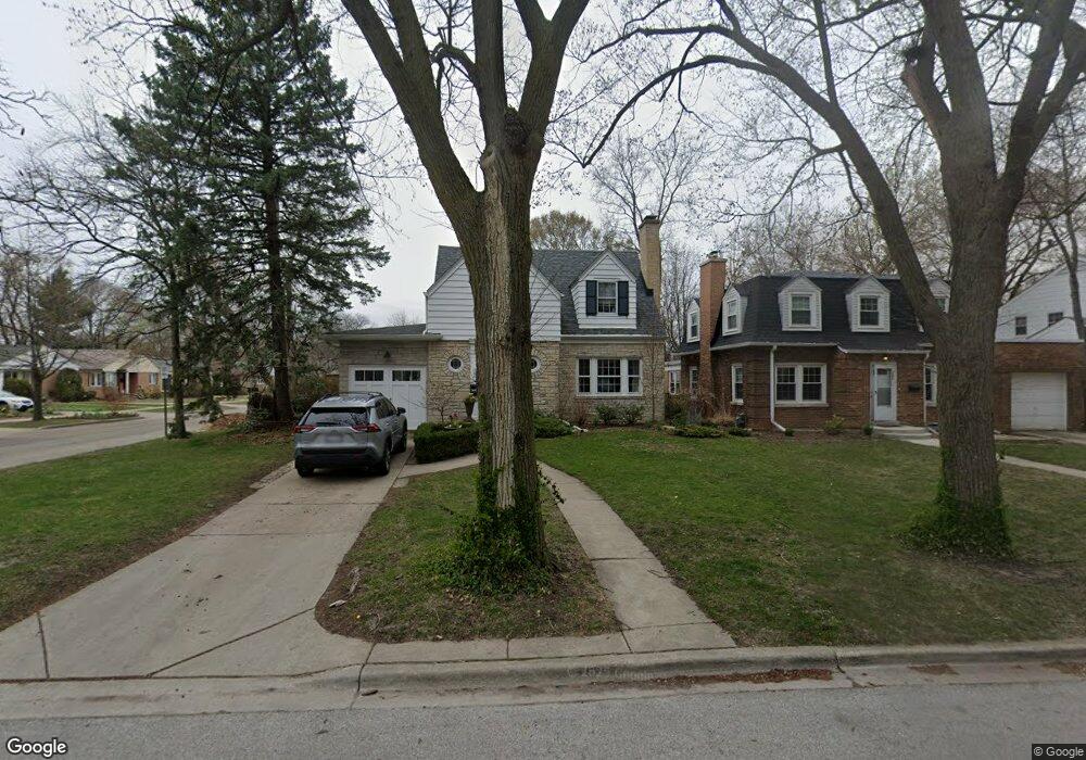
300 Ashland Ave Evanston, IL 60202
Southwest Evanston NeighborhoodEstimated Value: $565,758 - $622,000
4
Beds
2
Baths
1,638
Sq Ft
$366/Sq Ft
Est. Value
About This Home
This home is located at 300 Ashland Ave, Evanston, IL 60202 and is currently estimated at $598,690, approximately $365 per square foot. 300 Ashland Ave is a home located in Cook County with nearby schools including Dawes Elementary School, Chute Middle School, and Evanston Township High School.
Ownership History
Date
Name
Owned For
Owner Type
Purchase Details
Closed on
Aug 15, 2022
Sold by
Frazel Matthew F and Frazel Nancy R
Bought by
Matthew F Frazel Revocable Trust and Nancy R Snyder Revocable Trust
Current Estimated Value
Purchase Details
Closed on
Oct 17, 2006
Sold by
Brown William W and Brown Nancy D
Bought by
Frazel Matthew F and Snyder Nancy R
Home Financials for this Owner
Home Financials are based on the most recent Mortgage that was taken out on this home.
Original Mortgage
$200,000
Interest Rate
6.45%
Mortgage Type
Unknown
Create a Home Valuation Report for This Property
The Home Valuation Report is an in-depth analysis detailing your home's value as well as a comparison with similar homes in the area
Home Values in the Area
Average Home Value in this Area
Purchase History
| Date | Buyer | Sale Price | Title Company |
|---|---|---|---|
| Matthew F Frazel Revocable Trust | -- | None Listed On Document | |
| Frazel Matthew F | $486,000 | Multiple |
Source: Public Records
Mortgage History
| Date | Status | Borrower | Loan Amount |
|---|---|---|---|
| Previous Owner | Frazel Matthew F | $200,000 |
Source: Public Records
Tax History
| Year | Tax Paid | Tax Assessment Tax Assessment Total Assessment is a certain percentage of the fair market value that is determined by local assessors to be the total taxable value of land and additions on the property. | Land | Improvement |
|---|---|---|---|---|
| 2025 | $9,734 | $50,000 | $11,700 | $38,300 |
| 2024 | $9,734 | $40,154 | $9,900 | $30,254 |
| 2023 | $9,313 | $43,000 | $9,900 | $33,100 |
| 2022 | $9,313 | $43,000 | $9,900 | $33,100 |
| 2021 | $8,966 | $36,668 | $7,200 | $29,468 |
| 2020 | $8,905 | $36,668 | $7,200 | $29,468 |
| 2019 | $9,225 | $42,296 | $7,200 | $35,096 |
| 2018 | $7,337 | $29,866 | $6,000 | $23,866 |
| 2017 | $7,161 | $29,866 | $6,000 | $23,866 |
| 2016 | $7,515 | $31,815 | $6,000 | $25,815 |
| 2015 | $5,390 | $22,444 | $4,950 | $17,494 |
| 2014 | $5,353 | $22,444 | $4,950 | $17,494 |
| 2013 | $5,214 | $22,444 | $4,950 | $17,494 |
Source: Public Records
Map
Nearby Homes
- 1412 Brummel St Unit 2E
- 1321 Brummel St
- 1517 Dobson St
- 1217 Hull Terrace Unit 3A
- 1800 Kirk St
- 1609 Howard St Unit 2
- 2507 W Howard St
- 538 Wesley Ave
- 1104 Austin St
- 1736 Keeney St
- 7446 N Rockwell St
- 1507 Cleveland St
- 439 Ridge Ave Unit 2
- 7516 N California Ave
- 2109 Dobson St
- 135 Ridge Ave Unit 1W
- 704 Florence Ave
- 2124 Brummel St
- 817 Brummel St Unit 2N
- 7540 N Ridge Blvd Unit 6C
- 302 Ashland Ave
- 1511 Mulford St
- 310 Ashland Ave
- 316 Ashland Ave
- 1517 Mulford St
- 1506 Mulford St
- 1502 Mulford St
- 1508 Mulford St
- 1432 Mulford St
- 1512 Mulford St
- 1512 Mulford St Unit ID1306466P
- 1430 Mulford St
- 318 Ashland Ave
- 1521 Mulford St
- 301 Ashland Ave
- 1514 Mulford St
- 1426 Mulford St
- 305 Ashland Ave
- 311 Florence Ave
- 309 Ashland Ave
Your Personal Tour Guide
Ask me questions while you tour the home.