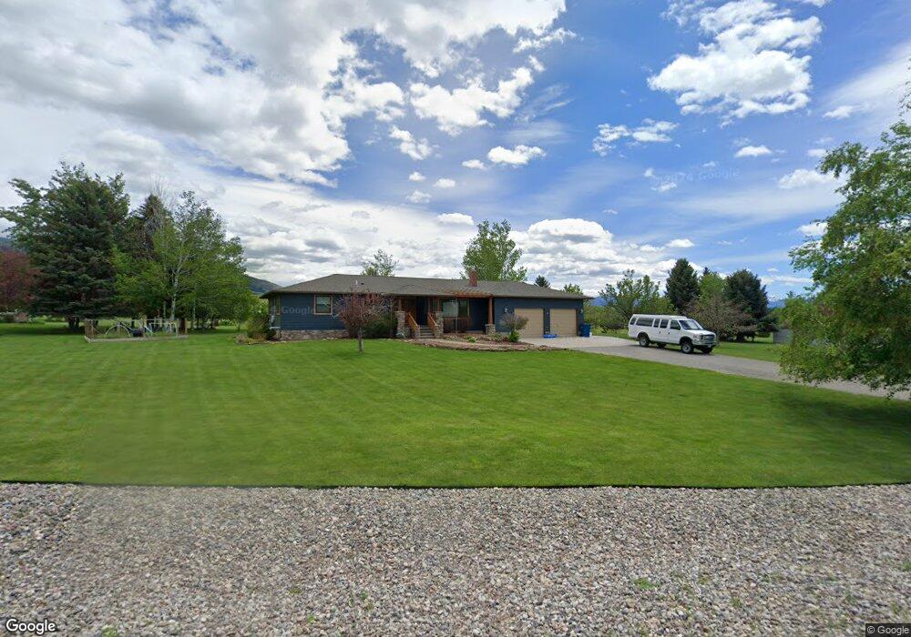
3000 Branding Iron Rd Bozeman, MT 59715
Estimated Value: $796,000 - $1,508,000
3
Beds
2
Baths
3,330
Sq Ft
$326/Sq Ft
Est. Value
About This Home
This home is located at 3000 Branding Iron Rd, Bozeman, MT 59715 and is currently estimated at $1,086,810, approximately $326 per square foot. 3000 Branding Iron Rd is a home located in Gallatin County with nearby schools including Hawthorne Elementary School, Chief Joseph Middle School, and Gallatin High School.
Ownership History
Date
Name
Owned For
Owner Type
Purchase Details
Closed on
Jul 27, 2005
Sold by
Osborn Robert and Osborn Susan
Bought by
Nirgenau Paul T and Nirgenau Blythe L
Current Estimated Value
Home Financials for this Owner
Home Financials are based on the most recent Mortgage that was taken out on this home.
Original Mortgage
$90,000
Outstanding Balance
$46,379
Interest Rate
5.56%
Mortgage Type
Unknown
Estimated Equity
$1,040,431
Create a Home Valuation Report for This Property
The Home Valuation Report is an in-depth analysis detailing your home's value as well as a comparison with similar homes in the area
Home Values in the Area
Average Home Value in this Area
Purchase History
| Date | Buyer | Sale Price | Title Company |
|---|---|---|---|
| Nirgenau Paul T | -- | Montana Title |
Source: Public Records
Mortgage History
| Date | Status | Borrower | Loan Amount |
|---|---|---|---|
| Open | Nirgenau Paul T | $90,000 |
Source: Public Records
Tax History Compared to Growth
Tax History
| Year | Tax Paid | Tax Assessment Tax Assessment Total Assessment is a certain percentage of the fair market value that is determined by local assessors to be the total taxable value of land and additions on the property. | Land | Improvement |
|---|---|---|---|---|
| 2025 | $3,868 | $974,200 | $0 | $0 |
| 2024 | $5,120 | $937,200 | $0 | $0 |
| 2023 | $5,343 | $937,200 | $0 | $0 |
| 2022 | $3,513 | $527,200 | $0 | $0 |
| 2021 | $3,901 | $527,200 | $0 | $0 |
| 2020 | $3,825 | $463,600 | $0 | $0 |
| 2019 | $3,759 | $463,600 | $0 | $0 |
| 2018 | $3,956 | $446,300 | $0 | $0 |
| 2017 | $3,467 | $446,300 | $0 | $0 |
| 2016 | $3,284 | $376,700 | $0 | $0 |
| 2015 | $3,264 | $376,700 | $0 | $0 |
| 2014 | $3,055 | $206,223 | $0 | $0 |
Source: Public Records
Map
Nearby Homes
- 7611 Sypes Canyon Rd
- Lot 28 Cold Smoke Dr
- 510 Cold Smoke
- 555 Glory Ln
- 687 Glory Ln
- Lot 26 Little Wolf Rd
- 65 Naya-Nuki Dr
- tbd Itana Cir
- 809 Cape Ave
- 8407 Little Gully Run
- 8663 E Panorama Dr
- NHN Springhill Rd
- 8651 E Panorama Dr
- 11 Kean Dr
- 3495 Deer Creek Dr
- 263 Nelson Rd
- 3380 Prince Ln
- 9440 Saddle Mountain Rd
- 3355 Royal Wolf Way Unit Lot 12
- 3391 Royal Wolf Way Unit Lot 13
- 3040 Branding Iron Rd
- 2950 Branding Iron Rd
- 2975 Branding Iron Rd
- 3080 Branding Iron Rd
- 2935 Branding Iron Rd
- 2900 Branding Iron Rd
- 3055 Branding Iron Rd
- 980 Spur Rd
- 3005 Ranch Rd
- 3095 Branding Iron Rd
- 3090 Ranch Rd
- 3070 Ranch Rd
- 2795 Rusty Nail Rd
- 2645 Rusty Nail Rd
- 3000 Ranch Rd
- 2775 Rusty Nail Rd
- 6760 Sypes Canyon Rd
- 6760 Sypes Canyon Rd
- 3094 Ranch Rd
- 3100 Branding Iron Rd