
Seller's Agent in 2025
Scott Taylor
Keller Williams
(601) 613-3856
2 in this area
122 Total Sales
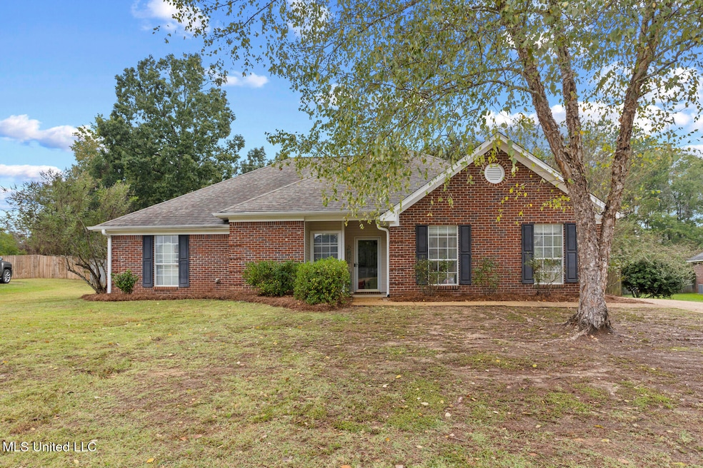


Located on a quiet cul-de-sac in a sought after Brandon neighborhood, this 3-bedroom, 2-bath home has been thoughtfully maintained and sits on one of the largest lots in Stonehendge. Inside, you'll find a comfortable floor plan with a spacious kitchen, a cozy living room, and tasteful finishes, including new vinyl plank flooring. The home has been well cared for and is ready for its next owner. Relax outdoors in the large backyard with plenty of space for pets or play. It backs up to a common area for added privacy. The side-entry garage adds convenience while the long driveway allows plenty of room for additional vehicles. Just minutes from I-20, the airport, shopping, schools, and restaurants, you'll love the location. The neighborhood has no homeowners association, so it's fee free and RV and boat-friendly. If you've been looking for a well-maintained home in a great neighborhood, look no further.
| Date | Type | Sale Price | Title Company |
|---|---|---|---|
| Warranty Deed | -- | None Listed On Document | |
| Warranty Deed | -- | None Available |
| Date | Status | Loan Amount | Loan Type |
|---|---|---|---|
| Open | $250,000 | New Conventional | |
| Previous Owner | $135,450 | New Conventional |
| Date | Event | Price | List to Sale | Price per Sq Ft |
|---|---|---|---|---|
| 11/21/2025 11/21/25 | Sold | -- | -- | -- |
| 10/25/2025 10/25/25 | Pending | -- | -- | -- |
| 10/22/2025 10/22/25 | For Sale | $260,000 | -- | $172 / Sq Ft |
| Year | Tax Paid | Tax Assessment Tax Assessment Total Assessment is a certain percentage of the fair market value that is determined by local assessors to be the total taxable value of land and additions on the property. | Land | Improvement |
|---|---|---|---|---|
| 2024 | $1,717 | $15,450 | $0 | $0 |
| 2023 | $1,620 | $14,707 | $0 | $0 |
| 2022 | $1,598 | $14,707 | $0 | $0 |
| 2021 | $1,598 | $14,707 | $0 | $0 |
| 2020 | $1,598 | $14,707 | $0 | $0 |
| 2019 | $1,441 | $13,213 | $0 | $0 |
| 2018 | $1,415 | $13,213 | $0 | $0 |
| 2017 | $1,415 | $13,213 | $0 | $0 |
| 2016 | $1,270 | $12,995 | $0 | $0 |
| 2015 | $1,270 | $12,995 | $0 | $0 |
| 2014 | $1,242 | $12,995 | $0 | $0 |
| 2013 | -- | $12,995 | $0 | $0 |
Seller's Agent in 2025
Scott Taylor
Keller Williams
(601) 613-3856
2 in this area
122 Total Sales
A
Seller Co-Listing Agent in 2025
Amanda Taylor
Keller Williams
(601) 977-9411
1 in this area
55 Total Sales
Buyer's Agent in 2025
Christal Warren
Trifecta Real Estate, LLC
(601) 941-4313
9 in this area
49 Total Sales
Source: MLS United
MLS Number: 4129353
APN: H09M-000011-00180
Disclaimer: Certain information contained herein is derived from information provided by parties other than Homes.com. All information provided is deemed reliable, but is not guaranteed to be accurate and should be independently verified.
![]() Information is deemed to be reliable but not guaranteed. Copyright 2026 MLS United, LLC.
Information is deemed to be reliable but not guaranteed. Copyright 2026 MLS United, LLC.
Ask me questions while you tour the home.