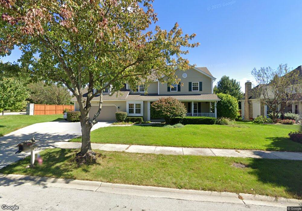
3008 Brossman St Naperville, IL 60564
Ashbury NeighborhoodEstimated Value: $687,000 - $718,000
4
Beds
3
Baths
2,931
Sq Ft
$239/Sq Ft
Est. Value
About This Home
This home is located at 3008 Brossman St, Naperville, IL 60564 and is currently estimated at $700,421, approximately $238 per square foot. 3008 Brossman St is a home located in Will County with nearby schools including Ellsworth Elementary School, Gordon Gregory Middle School, and Neuqua Valley High School.
Ownership History
Date
Name
Owned For
Owner Type
Purchase Details
Closed on
Apr 15, 2004
Sold by
Pyorala Keijo
Bought by
Schnell Mathew and Schnell Judith
Current Estimated Value
Home Financials for this Owner
Home Financials are based on the most recent Mortgage that was taken out on this home.
Original Mortgage
$297,600
Outstanding Balance
$127,352
Interest Rate
4.37%
Mortgage Type
Purchase Money Mortgage
Estimated Equity
$573,069
Purchase Details
Closed on
Jul 10, 2001
Sold by
Hunter Carissa A and Hunter Hector Carissa
Bought by
Pyorala Keijo
Home Financials for this Owner
Home Financials are based on the most recent Mortgage that was taken out on this home.
Original Mortgage
$287,300
Interest Rate
7.12%
Create a Home Valuation Report for This Property
The Home Valuation Report is an in-depth analysis detailing your home's value as well as a comparison with similar homes in the area
Home Values in the Area
Average Home Value in this Area
Purchase History
| Date | Buyer | Sale Price | Title Company |
|---|---|---|---|
| Schnell Mathew | $372,000 | Chicago Title Insurance Comp | |
| Pyorala Keijo | $338,000 | -- |
Source: Public Records
Mortgage History
| Date | Status | Borrower | Loan Amount |
|---|---|---|---|
| Open | Schnell Mathew | $297,600 | |
| Previous Owner | Pyorala Keijo | $287,300 |
Source: Public Records
Tax History Compared to Growth
Tax History
| Year | Tax Paid | Tax Assessment Tax Assessment Total Assessment is a certain percentage of the fair market value that is determined by local assessors to be the total taxable value of land and additions on the property. | Land | Improvement |
|---|---|---|---|---|
| 2024 | $13,425 | $212,966 | $65,131 | $147,835 |
| 2023 | $13,425 | $188,132 | $57,536 | $130,596 |
| 2022 | $12,401 | $177,159 | $54,428 | $122,731 |
| 2021 | $11,853 | $168,723 | $51,836 | $116,887 |
| 2020 | $11,628 | $166,050 | $51,015 | $115,035 |
| 2019 | $11,429 | $161,370 | $49,577 | $111,793 |
| 2018 | $11,518 | $159,758 | $48,487 | $111,271 |
| 2017 | $11,342 | $155,633 | $47,235 | $108,398 |
| 2016 | $11,321 | $152,283 | $46,218 | $106,065 |
| 2015 | $10,817 | $146,426 | $44,440 | $101,986 |
| 2014 | $10,817 | $137,503 | $44,440 | $93,063 |
| 2013 | $10,817 | $137,503 | $44,440 | $93,063 |
Source: Public Records
Map
Nearby Homes
- 2949 Brossman St
- 3004 Bennett Dr
- 2636 Salix Cir
- 2207 Sisters Ave
- 3212 Austin Ct
- 28W555 Leverenz Rd
- 2741 Gateshead Dr
- 1305 Morningstar Ct Unit 1A
- 3432 Caine Dr
- 1123 Thackery Ln
- 3616 Eliot Ln
- 1116 Hollingswood Ave
- 2736 Bluewater Cir
- 1134 Gateshead Dr
- 1329 Neskola Ct
- 3508 Tussell St
- 2543 Dewes Ln
- 2301 Mecan Dr
- 1321 Galena Ct
- 945 Winners Cup Ct Unit 945
- 3012 Brossman St
- 3119 Landore Dr
- 3016 Brossman St
- 3123 Landore Dr
- 3007 Brossman St
- 2944 Brossman St
- 3115 Landore Dr
- 3011 Brossman St
- 3020 Brossman St Unit 1
- 2942 Brossman St
- 2942 Brossman St Unit 407
- 2942 Brossman St Unit 2942
- 3015 Brossman St
- 3127 Landore Dr
- 2940 Brossman St
- 2947 Brossman St
- 3019 Brossman St
- 2938 Brossman St
- 3024 Brossman St
- 3111 Landore Dr