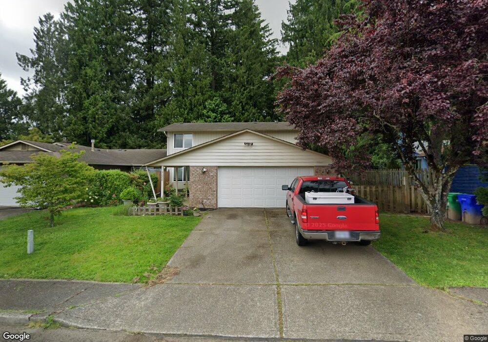
3008 SW 16th Cir Gresham, OR 97080
Southwest Gresham NeighborhoodEstimated Value: $378,956 - $667,000
3
Beds
6
Baths
1,360
Sq Ft
$339/Sq Ft
Est. Value
About This Home
This home is located at 3008 SW 16th Cir, Gresham, OR 97080 and is currently estimated at $460,489, approximately $338 per square foot. 3008 SW 16th Cir is a home located in Multnomah County with nearby schools including Hollydale Elementary School, Dexter McCarty Middle School, and Gresham High School.
Ownership History
Date
Name
Owned For
Owner Type
Purchase Details
Closed on
Sep 17, 2013
Sold by
Engberg Mark
Bought by
Daly Daniel P
Current Estimated Value
Home Financials for this Owner
Home Financials are based on the most recent Mortgage that was taken out on this home.
Original Mortgage
$166,250
Outstanding Balance
$123,486
Interest Rate
4.36%
Mortgage Type
New Conventional
Estimated Equity
$337,003
Create a Home Valuation Report for This Property
The Home Valuation Report is an in-depth analysis detailing your home's value as well as a comparison with similar homes in the area
Home Values in the Area
Average Home Value in this Area
Purchase History
| Date | Buyer | Sale Price | Title Company |
|---|---|---|---|
| Daly Daniel P | $175,000 | Fidelity National Title Or |
Source: Public Records
Mortgage History
| Date | Status | Borrower | Loan Amount |
|---|---|---|---|
| Open | Daly Daniel P | $166,250 |
Source: Public Records
Tax History
| Year | Tax Paid | Tax Assessment Tax Assessment Total Assessment is a certain percentage of the fair market value that is determined by local assessors to be the total taxable value of land and additions on the property. | Land | Improvement |
|---|---|---|---|---|
| 2025 | $3,670 | $180,370 | -- | -- |
| 2024 | $3,514 | $175,120 | -- | -- |
| 2023 | $3,201 | $170,020 | $0 | $0 |
| 2022 | $3,112 | $165,070 | $0 | $0 |
| 2021 | $3,033 | $160,270 | $0 | $0 |
| 2020 | $2,854 | $155,610 | $0 | $0 |
| 2019 | $2,779 | $151,080 | $0 | $0 |
| 2018 | $2,650 | $146,680 | $0 | $0 |
| 2017 | $2,543 | $142,410 | $0 | $0 |
| 2016 | $2,242 | $138,270 | $0 | $0 |
Source: Public Records
Map
Nearby Homes
- 3198 SW 16th Cir
- 1963 SW Myers Place
- 1744 SW Battaglia Ave
- 2092 SW Thomas Place
- 1960 SW 13th Ct
- 4010 SW 13th Ct
- 1829 SW 17th St
- 3857 SW Brittany Dr
- 2791 SW Myers Dr
- 2263 SW Phyllis Place
- 2607 SW Pleasant View Dr
- 3519 SW 28th Terrace
- 2277 SW Nancy Place
- 4540 SW 11th St Unit E4540
- 1859 SW Angeline Ave
- 4556 SW 11th St
- 2652 SW Phyllis Dr
- 3893 SW 4th St
- 4123 SW 26th Ct
- 1175 SW Chastain Dr
- 3002 SW 16th Cir
- 3012 SW 16th Cir
- 3018 SW 16th Cir
- 3017 SW 16th Cir
- 3046 SW 16th Cir
- 3041 SW 16th Cir
- 3037 SW 16th Cir
- 3022 SW 16th Cir
- 3066 SW 16th Cir
- 3057 SW 16th Cir
- 3028 SW 16th Cir
- 3061 SW 16th Cir
- 3076 SW 16th Cir
- 3040 SW 15th Ct
- 3067 SW 16th Cir
- 3020 SW 15th Ct
- 3032 SW 16th Cir
- 3071 SW 16th Cir
- 3070 SW 15th Ct
- 3086 SW 16th Cir
Your Personal Tour Guide
Ask me questions while you tour the home.