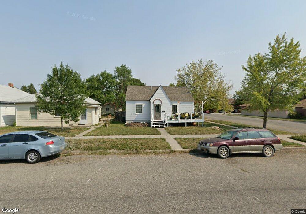
301 2nd Ave Laurel, MT 59044
Estimated Value: $272,000 - $294,000
3
Beds
1
Bath
1,428
Sq Ft
$198/Sq Ft
Est. Value
About This Home
This home is located at 301 2nd Ave, Laurel, MT 59044 and is currently estimated at $282,202, approximately $197 per square foot. 301 2nd Ave is a home located in Yellowstone County with nearby schools including Fred W. Graff School, West School, and Laurel Middle School.
Ownership History
Date
Name
Owned For
Owner Type
Purchase Details
Closed on
Dec 16, 2020
Sold by
Camp Chadron G and Stensrud Christina M
Bought by
Holliday Brittani N and Dickinson Jerod C
Current Estimated Value
Home Financials for this Owner
Home Financials are based on the most recent Mortgage that was taken out on this home.
Original Mortgage
$161,029
Outstanding Balance
$142,702
Interest Rate
2.7%
Mortgage Type
FHA
Estimated Equity
$139,500
Purchase Details
Closed on
Nov 24, 2009
Sold by
Wigen Joel
Bought by
Camp Chadron G and Stensrud Christina M
Home Financials for this Owner
Home Financials are based on the most recent Mortgage that was taken out on this home.
Original Mortgage
$119,897
Interest Rate
4.88%
Mortgage Type
New Conventional
Create a Home Valuation Report for This Property
The Home Valuation Report is an in-depth analysis detailing your home's value as well as a comparison with similar homes in the area
Home Values in the Area
Average Home Value in this Area
Purchase History
| Date | Buyer | Sale Price | Title Company |
|---|---|---|---|
| Holliday Brittani N | -- | First Montana Title Company | |
| Camp Chadron G | -- | None Available |
Source: Public Records
Mortgage History
| Date | Status | Borrower | Loan Amount |
|---|---|---|---|
| Open | Holliday Brittani N | $161,029 | |
| Previous Owner | Camp Chadron G | $119,897 |
Source: Public Records
Tax History
| Year | Tax Paid | Tax Assessment Tax Assessment Total Assessment is a certain percentage of the fair market value that is determined by local assessors to be the total taxable value of land and additions on the property. | Land | Improvement |
|---|---|---|---|---|
| 2025 | $2,106 | $247,700 | $56,449 | $191,251 |
| 2024 | $2,106 | $211,600 | $36,672 | $174,928 |
| 2023 | $1,836 | $198,000 | $36,672 | $161,328 |
| 2022 | $1,626 | $165,400 | $0 | $0 |
| 2021 | $1,639 | $165,400 | $0 | $0 |
| 2020 | $1,501 | $149,400 | $0 | $0 |
| 2019 | $1,516 | $149,400 | $0 | $0 |
| 2018 | $1,421 | $133,400 | $0 | $0 |
| 2017 | $1,136 | $133,400 | $0 | $0 |
| 2016 | $1,293 | $132,300 | $0 | $0 |
| 2015 | $1,278 | $132,300 | $0 | $0 |
| 2014 | $1,142 | $61,214 | $0 | $0 |
Source: Public Records
Map
Nearby Homes
- 110 E 5th St
- 116 4th Ave
- 603 5th Ave
- 516 Pennsylvania Ave
- 319 6th Ave
- 414 Wyoming Ave
- 601 E 5th St
- 310 (and 814 w 4) 8th Ave
- 211 Woodland Ave
- 102 8th Ave Unit B
- 1003 Montana Ave
- 120 Forrest Ave
- 717 E 5th St
- 717 E 5th, 506 Alder Ave
- 801 E 4th St
- 409 Maple Ave
- 208 West Ave
- 419 Durland Ave
- 605 Date Ave
- 1109 10th Ave
Your Personal Tour Guide
Ask me questions while you tour the home.