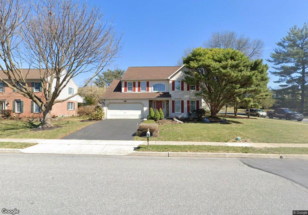
301 Broad St Reading, PA 19608
Estimated Value: $436,430 - $535,000
4
Beds
3
Baths
2,451
Sq Ft
$193/Sq Ft
Est. Value
About This Home
This home is located at 301 Broad St, Reading, PA 19608 and is currently estimated at $473,358, approximately $193 per square foot. 301 Broad St is a home located in Berks County with nearby schools including Whitfield Elementary School, Wilson West Middle School, and Wilson High School.
Ownership History
Date
Name
Owned For
Owner Type
Purchase Details
Closed on
Dec 10, 2014
Sold by
Bondarchuk John L and Sloan Elizabeth A
Bought by
Bondarchuk John L
Current Estimated Value
Home Financials for this Owner
Home Financials are based on the most recent Mortgage that was taken out on this home.
Original Mortgage
$197,000
Outstanding Balance
$149,439
Interest Rate
3.66%
Mortgage Type
New Conventional
Estimated Equity
$323,919
Purchase Details
Closed on
Apr 24, 1998
Bought by
Bondarchuk John L and Sloan Elizabeth
Create a Home Valuation Report for This Property
The Home Valuation Report is an in-depth analysis detailing your home's value as well as a comparison with similar homes in the area
Home Values in the Area
Average Home Value in this Area
Purchase History
| Date | Buyer | Sale Price | Title Company |
|---|---|---|---|
| Bondarchuk John L | -- | None Available | |
| Bondarchuk John L | $180,000 | -- |
Source: Public Records
Mortgage History
| Date | Status | Borrower | Loan Amount |
|---|---|---|---|
| Open | Bondarchuk John L | $197,000 |
Source: Public Records
Tax History
| Year | Tax Paid | Tax Assessment Tax Assessment Total Assessment is a certain percentage of the fair market value that is determined by local assessors to be the total taxable value of land and additions on the property. | Land | Improvement |
|---|---|---|---|---|
| 2025 | $3,133 | $175,900 | $27,500 | $148,400 |
| 2024 | $8,202 | $175,900 | $27,500 | $148,400 |
| 2023 | $7,935 | $175,900 | $27,500 | $148,400 |
| 2022 | $7,736 | $175,900 | $27,500 | $148,400 |
| 2021 | $7,438 | $175,900 | $27,500 | $148,400 |
| 2020 | $7,438 | $175,900 | $27,500 | $148,400 |
| 2019 | $7,326 | $175,900 | $27,500 | $148,400 |
| 2018 | $7,201 | $175,900 | $27,500 | $148,400 |
| 2017 | $7,091 | $175,900 | $27,500 | $148,400 |
| 2016 | $2,533 | $175,900 | $27,500 | $148,400 |
| 2015 | $2,533 | $175,900 | $27,500 | $148,400 |
| 2014 | $2,533 | $175,900 | $27,500 | $148,400 |
Source: Public Records
Map
Nearby Homes
- 12 Hidden Brook Way
- 2930 Reedy Rd
- 4205 Penn Ave
- 3420 Penn Ave
- 204 Wilshire Blvd
- 4135 Hill Terrace Dr
- 4143 Hill Terrace Dr
- 4189 Hill Terrace Dr
- 2923 Elm Place
- 73 Michigan Dr
- 14 Laird St
- 2601 Reading Blvd
- 11 Fiorino Way Unit 1
- 1334 W Wyomissing Blvd
- 23 Laura Ct
- 2405 Garden Ln
- 2121 Bressler Dr
- 62 Stella Dr
- 3305 Regency Dr
- 119 Woodside Ave
- 303 Broad St
- 300 Elizabeth Dr
- 302 Elizabeth Dr
- 305 Broad St
- 276 Broad St
- 304 Elizabeth Dr
- 307 Broad St
- 270 Elizabeth Dr
- 173 Kirkwood Ave
- 306 Elizabeth Dr
- 172 Kirkwood Ave
- 260 Broad St
- 309 Broad St
- 176 Ray Rd
- 301 Elizabeth Dr
- 308 Elizabeth Dr
- 256 Elizabeth Dr
- 174 Kirkwood Ave
- 175 Kirkwood Ave
- 248 Broad St
Your Personal Tour Guide
Ask me questions while you tour the home.