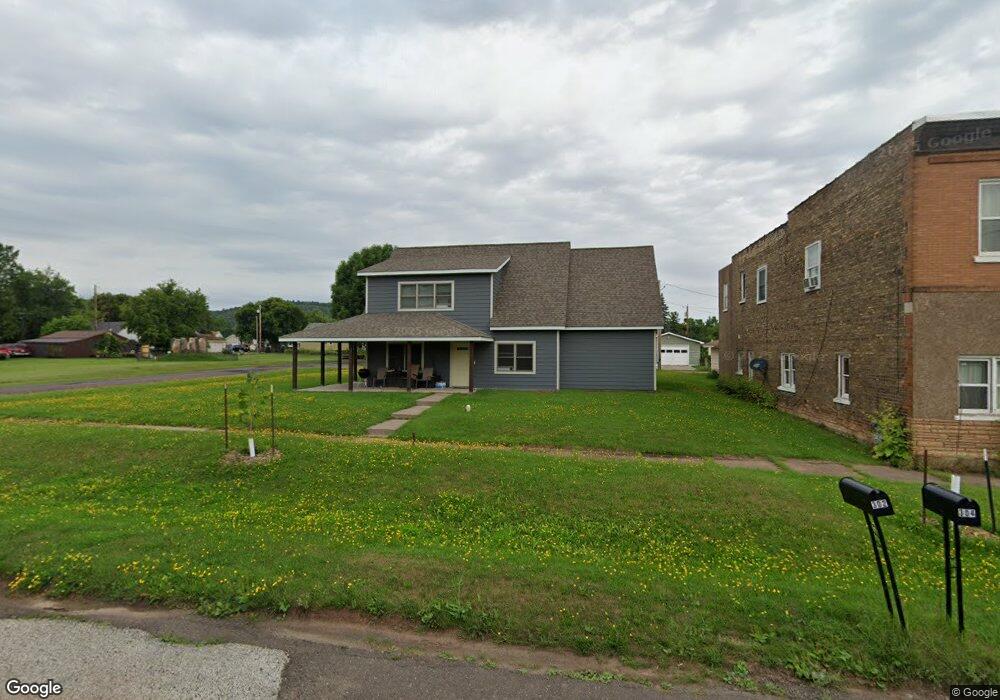
301 E Gary St Duluth, MN 55808
Gary-New Duluth NeighborhoodEstimated Value: $217,000 - $262,000
3
Beds
2
Baths
1,418
Sq Ft
$166/Sq Ft
Est. Value
About This Home
This home is located at 301 E Gary St, Duluth, MN 55808 and is currently estimated at $236,041, approximately $166 per square foot. 301 E Gary St is a home located in St. Louis County with nearby schools including Stowe Elementary School, Lincoln Park Middle School, and Denfeld High School.
Ownership History
Date
Name
Owned For
Owner Type
Purchase Details
Closed on
Apr 14, 2011
Sold by
Minnesota Housing Finance Agency
Bought by
Northern Communities Land Trust
Current Estimated Value
Purchase Details
Closed on
Aug 17, 2010
Sold by
Burk Michael W and Burk Jennifer L
Bought by
Minnesota Housing Finance Agency
Purchase Details
Closed on
Jun 6, 2006
Sold by
Habitat For Humanity Duluth Inc
Bought by
Northern Communities Land Trust
Create a Home Valuation Report for This Property
The Home Valuation Report is an in-depth analysis detailing your home's value as well as a comparison with similar homes in the area
Home Values in the Area
Average Home Value in this Area
Purchase History
| Date | Buyer | Sale Price | Title Company |
|---|---|---|---|
| Northern Communities Land Trust | $95,000 | None Available | |
| Minnesota Housing Finance Agency | $135,508 | None Available | |
| Northern Communities Land Trust | $15,000 | Arrowhead |
Source: Public Records
Tax History
| Year | Tax Paid | Tax Assessment Tax Assessment Total Assessment is a certain percentage of the fair market value that is determined by local assessors to be the total taxable value of land and additions on the property. | Land | Improvement |
|---|---|---|---|---|
| 2024 | $2,144 | $235,000 | $17,700 | $217,300 |
| 2023 | $2,144 | $226,100 | $17,400 | $208,700 |
| 2022 | $2,666 | $220,500 | $21,800 | $198,700 |
| 2021 | $2,546 | $179,700 | $17,700 | $162,000 |
| 2020 | $2,194 | $175,700 | $17,400 | $158,300 |
| 2019 | $2,342 | $153,100 | $15,100 | $138,000 |
| 2018 | $1,622 | $162,300 | $15,100 | $147,200 |
| 2017 | $1,624 | $127,500 | $19,800 | $107,700 |
| 2016 | $1,590 | $150,700 | $20,900 | $129,800 |
| 2015 | $1,617 | $101,700 | $15,800 | $85,900 |
| 2014 | $1,617 | $101,700 | $15,800 | $85,900 |
Source: Public Records
Map
Nearby Homes
- 1xx E Gary St
- 1219 96th Ave W
- 1215 103rd Ave W
- 13xx 99th Ave W
- 1325 104th Ave W
- 10 Glencrest Ct
- 23 Coban Dr
- 119 96th Ave W
- 29 Burger Dr
- XXX Commonwealth Ave
- 1063 86th Ave W
- 1010 85th Ave W
- TBD Arbor St
- 9118 Gogebic St
- 125 Goldys Way
- 8408 Potters Place
- 8313 Eric Shaffer Way
- 121 Kayak View
- 8620 Maynard Place
- 8602 Maynard Place
- 309 E Gary St
- 1310 97th Ave W
- 15xx E Gary St
- 1309 96th Ave W
- 1314 97th Ave W
- 325 E Gary St
- 1311 96th Ave W
- 213 E Gary St
- 1316 97th Ave W
- 1227 96th Ave W
- 1313 96th Ave W
- 1225 97th Ave W
- 1317 97th Ave W
- 1316 98th Ave W
- 1221 96th Ave W
- 402 E Gary St
- 1326 97th Ave W
- 1323 97th Ave W
- 1318 98th Ave W
- 1216 97th Ave W
Your Personal Tour Guide
Ask me questions while you tour the home.