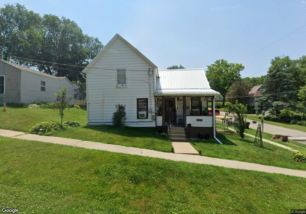
301 Jefferson St Colfax, IA 50054
Estimated Value: $147,000 - $181,000
3
Beds
1
Bath
1,178
Sq Ft
$136/Sq Ft
Est. Value
About This Home
This home is located at 301 Jefferson St, Colfax, IA 50054 and is currently estimated at $160,736, approximately $136 per square foot. 301 Jefferson St is a home located in Jasper County with nearby schools including Colfax-Mingo Elementary School and Colfax-Mingo High School.
Ownership History
Date
Name
Owned For
Owner Type
Purchase Details
Closed on
Jun 24, 2016
Sold by
Clevenger Properties Llc
Bought by
Allman Justin L
Current Estimated Value
Home Financials for this Owner
Home Financials are based on the most recent Mortgage that was taken out on this home.
Original Mortgage
$68,431
Outstanding Balance
$54,587
Interest Rate
3.64%
Mortgage Type
New Conventional
Estimated Equity
$106,149
Create a Home Valuation Report for This Property
The Home Valuation Report is an in-depth analysis detailing your home's value as well as a comparison with similar homes in the area
Purchase History
| Date | Buyer | Sale Price | Title Company |
|---|---|---|---|
| Allman Justin L | $68,000 | Jasper County Abstract Co |
Source: Public Records
Mortgage History
| Date | Status | Borrower | Loan Amount |
|---|---|---|---|
| Open | Allman Justin L | $68,431 |
Source: Public Records
Tax History
| Year | Tax Paid | Tax Assessment Tax Assessment Total Assessment is a certain percentage of the fair market value that is determined by local assessors to be the total taxable value of land and additions on the property. | Land | Improvement |
|---|---|---|---|---|
| 2025 | $1,838 | $118,170 | $10,350 | $107,820 |
| 2024 | $1,838 | $106,730 | $10,350 | $96,380 |
| 2023 | $1,846 | $106,730 | $10,350 | $96,380 |
| 2022 | $1,520 | $86,020 | $10,350 | $75,670 |
| 2021 | $1,440 | $76,690 | $10,350 | $66,340 |
| 2020 | $1,440 | $68,950 | $7,240 | $61,710 |
| 2019 | $1,244 | $57,870 | $0 | $0 |
| 2018 | $1,244 | $57,870 | $0 | $0 |
| 2017 | $1,204 | $48,440 | $0 | $0 |
| 2016 | $1,204 | $48,440 | $0 | $0 |
| 2015 | $1,198 | $38,010 | $0 | $0 |
| 2014 | $894 | $38,010 | $0 | $0 |
Source: Public Records
Map
Nearby Homes
- 205 E Division St
- 222 E Broadway St
- 300 E Front St
- 226 S Iowa St
- 108 S Walnut St
- 655 E Division St
- 110 W Broadway St
- 400 S Goodrich St
- 119 W Washington St
- 520 S Oak Park Ave
- 215 W Spring St
- 624 S Goodrich St
- 500 W Washington St
- 501 W Broadway St
- 17 S Kelly St
- 1132 S Goodrich St
- 1161 S Goodrich St
- 11213 Orchard Ave
- HWY 117 at Intersection of Fleet Ave
- 0 W 120th St S
- 309 Jefferson St
- 306 E Division St
- 310 E Division St
- 209 Jefferson St
- 224 E Division St
- 312 E Division St
- 103 N Lincoln St
- 0 S Lincoln St
- 203 Jefferson St
- 311 E Division St
- 212 E Division St
- 206 Jefferson St
- 305 E Division St Unit A
- 305 E Division St
- 225 E Division St
- 235 E Howard St
- 400 E Division St
- 16 N Lincoln St
- 315 E Howard St Unit A
- 315 E Howard St