K
Seller's Agent in 2025
Katelyn Price
RE/MAX
(515) 290-2441
11 Total Sales

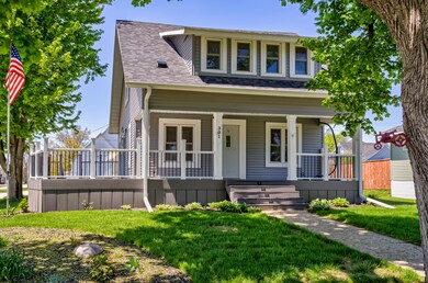

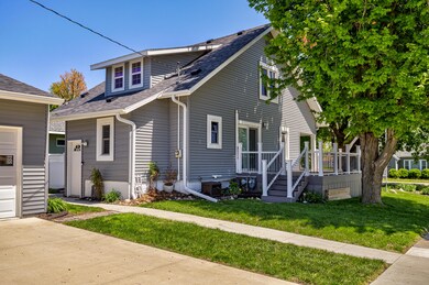
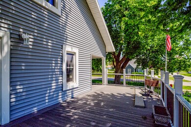

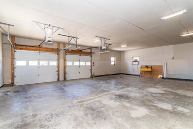
Welcome to 301 N Pearl St! This charming 3-bedroom, 2-bathroom home offers the perfect blend of comfort and functionality. Enjoy the convenience of a recently renovated bathroom and laundry room just off the kitchen, along with new kitchen appliances. The basement provides abundant storage space, while outside, a new 30x36, oversized three-car garage, built in 2021, and recently insulated and drywalled, offers endless potential for a man cave, workshop, or extra storage. The backyard features a handy shed and a beautiful garden that enhances the curb appeal. Don't miss this move-in-ready gem!
Last Agent to Sell the Property
RE/MAX REAL ESTATE CENTER License #S70499000 Listed on: 05/09/2025

Last Buyer's Agent
Member Non
CENTRAL IOWA BOARD OF REALTORS
| Date | Type | Sale Price | Title Company |
|---|---|---|---|
| Warranty Deed | $230,000 | None Listed On Document | |
| Warranty Deed | -- | None Available | |
| Quit Claim Deed | -- | -- |
| Date | Status | Loan Amount | Loan Type |
|---|---|---|---|
| Open | $232,323 | New Conventional | |
| Previous Owner | $88,257 | New Conventional |
| Date | Event | Price | List to Sale | Price per Sq Ft |
|---|---|---|---|---|
| 06/16/2025 06/16/25 | Sold | $230,000 | +4.6% | $158 / Sq Ft |
| 05/09/2025 05/09/25 | Pending | -- | -- | -- |
| 05/09/2025 05/09/25 | For Sale | $219,900 | -- | $151 / Sq Ft |
| Year | Tax Paid | Tax Assessment Tax Assessment Total Assessment is a certain percentage of the fair market value that is determined by local assessors to be the total taxable value of land and additions on the property. | Land | Improvement |
|---|---|---|---|---|
| 2025 | $2,546 | $180,300 | $9,100 | $171,200 |
| 2024 | $2,568 | $175,900 | $6,700 | $169,200 |
| 2023 | $2,318 | $174,400 | $6,700 | $167,700 |
| 2022 | $1,312 | $136,700 | $4,600 | $132,100 |
| 2021 | $1,658 | $134,800 | $4,600 | $130,200 |
| 2020 | $1,608 | $101,100 | $4,600 | $96,500 |
| 2019 | $1,608 | $101,100 | $4,600 | $96,500 |
| 2018 | $1,384 | $93,000 | $4,600 | $88,400 |
| 2017 | $1,384 | $93,000 | $4,600 | $88,400 |
| 2016 | $1,364 | $85,400 | $4,600 | $80,800 |
| 2015 | $1,364 | $85,400 | $4,600 | $80,800 |
| 2014 | $1,342 | $84,300 | $3,500 | $80,800 |
K
Seller's Agent in 2025
Katelyn Price
RE/MAX
(515) 290-2441
11 Total Sales
M
Buyer's Agent in 2025
Member Non
CENTRAL IOWA BOARD OF REALTORS
Source: Central Iowa Board of REALTORS®
MLS Number: 67370
APN: 04-21-215-360