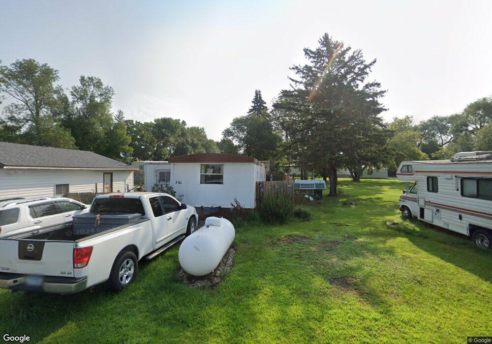
301 Pershing Ave Hitterdal, MN 56552
Estimated Value: $70,082 - $172,000
3
Beds
1
Bath
980
Sq Ft
$133/Sq Ft
Est. Value
About This Home
This home is located at 301 Pershing Ave, Hitterdal, MN 56552 and is currently estimated at $130,021, approximately $132 per square foot. 301 Pershing Ave is a home located in Clay County with nearby schools including Ulen-Hitterdal Elementary School.
Ownership History
Date
Name
Owned For
Owner Type
Purchase Details
Closed on
Oct 27, 2017
Sold by
Craig Bradley J and Craig Angalea M
Bought by
Bates Anthony H and Anderson Jeanine L
Current Estimated Value
Purchase Details
Closed on
Jul 30, 2014
Sold by
Nobriga Gordian F and Nobriga Ann
Bought by
Craig Bradley J and Brasel Angalea
Purchase Details
Closed on
Mar 8, 2012
Sold by
Nobriga Gordian F and Nobriga Ann
Bought by
Rohde Thomas A and Klienschmidt Michelle L
Purchase Details
Closed on
Apr 11, 2008
Sold by
Jensen Evelyn
Bought by
Nobriga Gordian F
Create a Home Valuation Report for This Property
The Home Valuation Report is an in-depth analysis detailing your home's value as well as a comparison with similar homes in the area
Purchase History
| Date | Buyer | Sale Price | Title Company |
|---|---|---|---|
| Bates Anthony H | $24,000 | Consolidation Title | |
| Craig Bradley J | $16,752 | Backer County Title Services | |
| Rohde Thomas A | -- | Becker County Title Services | |
| Nobriga Gordian F | $16,000 | None Available |
Source: Public Records
Tax History
| Year | Tax Paid | Tax Assessment Tax Assessment Total Assessment is a certain percentage of the fair market value that is determined by local assessors to be the total taxable value of land and additions on the property. | Land | Improvement |
|---|---|---|---|---|
| 2025 | $324 | $28,200 | $5,500 | $22,700 |
| 2024 | $324 | $29,200 | $5,500 | $23,700 |
| 2023 | $296 | $25,900 | $5,500 | $20,400 |
| 2022 | $306 | $23,800 | $5,500 | $18,300 |
| 2021 | $320 | $22,600 | $5,500 | $17,100 |
| 2020 | $280 | $21,700 | $5,500 | $16,200 |
| 2019 | $290 | $21,800 | $5,500 | $16,300 |
| 2018 | $286 | $22,400 | $5,500 | $16,900 |
| 2017 | $264 | $21,400 | $5,500 | $15,900 |
| 2016 | $270 | $17,800 | $6,200 | $11,600 |
| 2015 | $149 | $21,000 | $6,200 | $14,800 |
| 2014 | $404 | $21,000 | $6,200 | $14,800 |
Source: Public Records
Map
Nearby Homes
- 6673 230th St N
- TBD 290th St N
- 3316 290th St N
- 25712 15th Ave N
- 1782 225th St N
- 2300 Scenic Ln
- 2304 Scenic Ln
- 2306 Scenic Ln
- 2310 Scenic Ln
- 2303 Scenic Ln
- 2312 Scenic Ln
- 2307 Scenic Ln
- 2316 Scenic Ln
- 2309 Scenic Ln
- 2311 Scenic Ln
- 2315 Scenic Ln
- 2520 Valley View
- 2524 Valley View
- 2530 Valley View
- 2516 Valley View
- 105 Dead End St
- 103 Dead End St
- 209 Pershing Ave
- 309 Pershing Ave
- 206 Pershing Ave
- 101 Dead End St
- 307 Pershing Ave
- 213 Lincoln St
- 311 Pershing Ave
- 307 Lincoln St
- 305 Highway 32 S
- 301 Highway 32 S
- 212 Lincoln St
- 403 Highway 32 S
- 214 Lincoln St
- 403 Highway 32 N
- 216 Lincoln St
- 302 Lincoln St
- 102 Viking Ave S
- 111 Spartan Ave
Your Personal Tour Guide
Ask me questions while you tour the home.