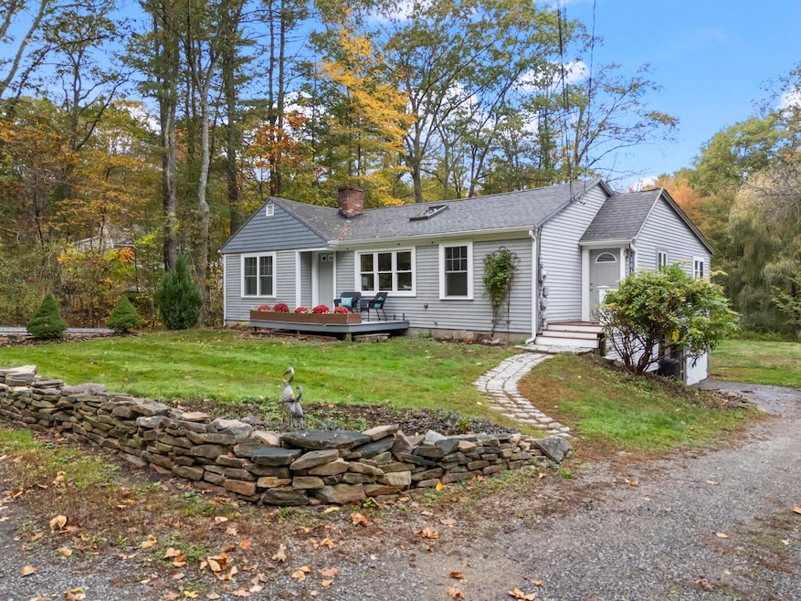
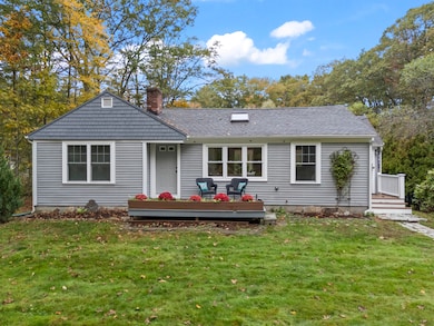
301 Route 103 York, ME 03909
York NeighborhoodEstimated payment $3,303/month
Highlights
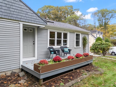
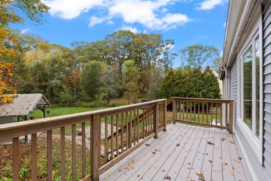
- Deck
- Vaulted Ceiling
- Wood Flooring
- Coastal Ridge Elementary School Rated A-
- Ranch Style House
- 1 Fireplace
About This Home
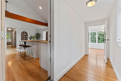
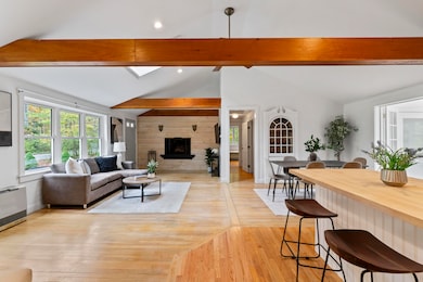
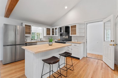
Surprisingly spacious and full of charm, this ranch style home in York offers far more than meets the eye. Featuring vaulted ceilings and an open layout, it feels bright, airy, and inviting the moment you walk in. No matter which direction you take to get here, you'll enjoy a beautiful drive with views of the river and ocean — a daily reminder of what makes this area so special. Set in a desirable area near the Town Docks where you can keep your boat or launch your paddleboard and kayaks, the popular Wiggly Bridge, and scenic Land Trust trails offered by both the Kittery and York Land Trusts, this home is ideal for those looking to downsize and enjoy easy one floor living. Inside, you'll find 2+ bedrooms, a stunning bathroom with both a soaking tub and large tiled shower, and wood floors throughout the main level. The lower level adds flexibility with a bonus room, full bath and separate entrance making it perfect for guests seeking their own space. Outside, unwind in the gazebo style Zen den, the perfect spot to relax after a walk along the nearby trails or a day out on the water!
Listing Agent
Keller Williams Coastal and Lakes & Mountains Realty Listed on: 10/13/2025

Home Details
Home Type
- Single Family
Est. Annual Taxes
- $3,308
Year Built
- Built in 1969
Lot Details
- 0.68 Acre Lot
- Open Lot
- Property is zoned RES-1A
Parking
- Paved Parking
Home Design
- Ranch Style House
- Wood Frame Construction
- Shingle Roof
- Vinyl Siding
Interior Spaces
- Vaulted Ceiling
- Ceiling Fan
- 1 Fireplace
- Double Pane Windows
Kitchen
- Gas Range
- Dishwasher
Flooring
- Wood
- Tile
Bedrooms and Bathrooms
- 2 Bedrooms
- Walk-In Closet
- 2 Full Bathrooms
- Soaking Tub
Laundry
- Dryer
- Washer
Basement
- Basement Fills Entire Space Under The House
- Interior Basement Entry
- Natural lighting in basement
Utilities
- No Cooling
- Forced Air Heating System
- Heating System Mounted To A Wall or Window
- Generator Hookup
- Private Water Source
- Private Sewer
- Internet Available
Additional Features
- Deck
- Property is near a golf course
Community Details
- No Home Owners Association
Listing and Financial Details
- Tax Lot 18
- Assessor Parcel Number YORK-000087-000000-000018
Map
Home Values in the Area
Average Home Value in this Area
Tax History
| Year | Tax Paid | Tax Assessment Tax Assessment Total Assessment is a certain percentage of the fair market value that is determined by local assessors to be the total taxable value of land and additions on the property. | Land | Improvement |
|---|---|---|---|---|
| 2024 | $3,367 | $400,800 | $177,400 | $223,400 |
| 2023 | $3,037 | $359,400 | $136,000 | $223,400 |
| 2022 | $2,824 | $330,300 | $121,200 | $209,100 |
| 2021 | $2,714 | $272,800 | $97,500 | $175,300 |
| 2020 | $2,652 | $238,900 | $97,500 | $141,400 |
| 2019 | $2,616 | $234,600 | $94,600 | $140,000 |
| 2018 | $1,280 | $227,400 | $88,700 | $138,700 |
| 2017 | $2,460 | $224,700 | $88,700 | $136,000 |
| 2016 | $2,505 | $224,700 | $88,700 | $136,000 |
| 2015 | $2,428 | $220,700 | $88,700 | $132,000 |
| 2014 | $2,361 | $220,700 | $88,700 | $132,000 |
| 2013 | $2,302 | $220,700 | $88,700 | $132,000 |
Property History
| Date | Event | Price | List to Sale | Price per Sq Ft |
|---|---|---|---|---|
| 11/17/2025 11/17/25 | Price Changed | $575,000 | -8.0% | $296 / Sq Ft |
| 10/13/2025 10/13/25 | For Sale | $625,000 | -- | $322 / Sq Ft |
Purchase History
| Date | Type | Sale Price | Title Company |
|---|---|---|---|
| Deed | -- | None Available | |
| Warranty Deed | -- | None Available | |
| Deed | -- | None Available | |
| Deed | -- | None Available | |
| Warranty Deed | -- | None Available | |
| Warranty Deed | -- | None Available |
Source: Maine Listings
MLS Number: 1640698
APN: YORK-000087-000000-000018
Disclaimer: Certain information contained herein is derived from information provided by parties other than Homes.com. All information provided is deemed reliable, but is not guaranteed to be accurate and should be independently verified.
![]() Listing data is derived in whole or in part from Maine Real Estate Information System, Inc. (d/b/a Maine Listings) and is for consumers' personal, noncommercial use only. Dimensions are approximate and not guaranteed. All data should be independently verified.
Listing data is derived in whole or in part from Maine Real Estate Information System, Inc. (d/b/a Maine Listings) and is for consumers' personal, noncommercial use only. Dimensions are approximate and not guaranteed. All data should be independently verified.
© 2025 Maine Real Estate Information System, Inc. All Rights Reserved. Equal Housing Opportunity.
Homes.com, LLC, 17600 Laguna Canyon Rd Irvine, CA 92618 (888)-952-6393
![]()
- 25 Brave Boat Harbor Rd
- 2 Bristol Ln
- 109 Bartlett Rd
- 8 Old Seabury Rd
- 357 Southside Rd
- 12 Washburn Farm Ln Unit 3
- 50 Seabury Rd
- 2 Washburn Farm Ln Unit 1
- 7 Washburn Farm Ln Unit 9
- 13 Washburn Farm Ln Unit 7
- 18 Washburn Farm Ln Unit 4
- 20 Washburn Farm Ln Unit 5
- 18 Woodside Meadow Rd Unit 4
- 3 Long Cove Rd
- 25 Bartlett Rd
- 4 Ice House Point
- 23 Harmon Park Rd
- 9 Jeffrey Dr
- 419 & 425 York St
- 298 York St Unit 10
- 26-3 Regency Cir
- 790 York St Unit 2
- 12 Garrison Ave
- 100 Shepards Cove Rd Unit B2
- 148 Whipple Rd
- 3 Walbach St
- 3 Walbach St
- 3 Walbach St
- 17 Elm Ct
- 7 Stoneridge Ln Unit 5
- 3 Walker St
- 5 Pleasant St Unit A
- 41 Seacoast Terrace
- 4 Stimson St
- 34 Mendum Ave
- 279 Marcy St Unit 3
- 20 Chapel St Unit 2
- 20 Chapel St Unit 5
- 8 Chapel St