Estimated Value: $65,407 - $199,000
1
Bed
1
Bath
432
Sq Ft
$275/Sq Ft
Est. Value
About This Home
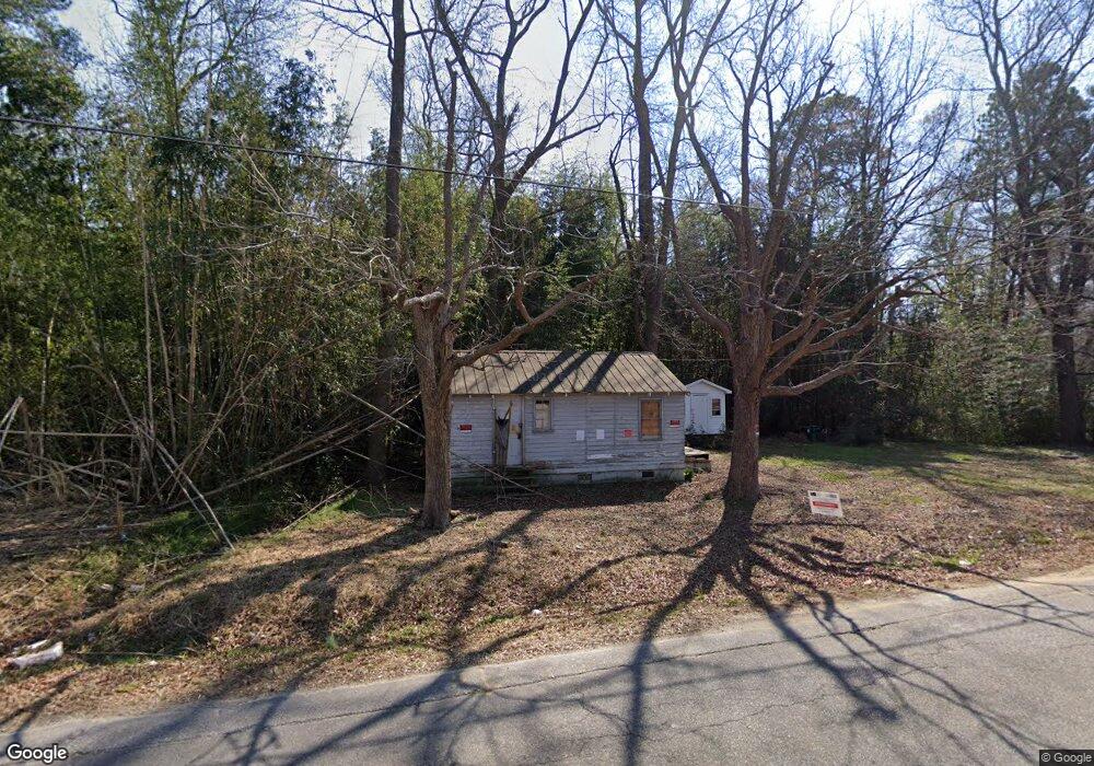
This home is located at 301 St Matthews Rd, Erwin, NC 28339 and is currently estimated at $118,852, approximately $275 per square foot. 301 St Matthews Rd is a home with nearby schools including Erwin Elementary School, Gentry Primary, and Coats-Erwin Middle School.
Ownership History
Date
Name
Owned For
Owner Type
Purchase Details
Closed on
Jul 5, 2006
Sold by
Bradshaw Roy Wesley
Bought by
Hounts John D Randall
Current Estimated Value
Home Financials for this Owner
Home Financials are based on the most recent Mortgage that was taken out on this home.
Original Mortgage
$18,000
Interest Rate
6.54%
Mortgage Type
Purchase Money Mortgage
Purchase Details
Closed on
Jun 27, 2006
Sold by
Hartley Kenneth Dale
Bought by
Bradsha Roy Wesley
Home Financials for this Owner
Home Financials are based on the most recent Mortgage that was taken out on this home.
Original Mortgage
$18,000
Interest Rate
6.54%
Mortgage Type
Purchase Money Mortgage
Create a Home Valuation Report for This Property
The Home Valuation Report is an in-depth analysis detailing your home's value as well as a comparison with similar homes in the area
Home Values in the Area
Average Home Value in this Area
Purchase History
| Date | Buyer | Sale Price | Title Company |
|---|---|---|---|
| Hounts John D Randall | $18,000 | None Available | |
| Bradsha Roy Wesley | $15,000 | None Available |
Source: Public Records
Mortgage History
| Date | Status | Borrower | Loan Amount |
|---|---|---|---|
| Closed | Hounts John D Randall | $18,000 |
Source: Public Records
Tax History Compared to Growth
Tax History
| Year | Tax Paid | Tax Assessment Tax Assessment Total Assessment is a certain percentage of the fair market value that is determined by local assessors to be the total taxable value of land and additions on the property. | Land | Improvement |
|---|---|---|---|---|
| 2025 | $239 | $13,190 | $0 | $0 |
| 2024 | $239 | $13,190 | $0 | $0 |
| 2023 | $239 | $13,190 | $0 | $0 |
| 2022 | $239 | $13,190 | $0 | $0 |
| 2021 | $291 | $15,190 | $0 | $0 |
| 2020 | $291 | $15,190 | $0 | $0 |
| 2019 | $276 | $15,190 | $0 | $0 |
| 2018 | $274 | $15,190 | $0 | $0 |
| 2017 | $274 | $15,190 | $0 | $0 |
| 2016 | $294 | $16,720 | $0 | $0 |
| 2015 | $287 | $16,720 | $0 | $0 |
| 2014 | $287 | $16,720 | $0 | $0 |
Source: Public Records
Map
Nearby Homes
- 602 Wondertown Dr
- 103 Hope St
- 2602 Erwin Rd
- 207 2nd St
- 0 Denim Dr
- 213 Maye St
- 233 Jenkins St
- 201 4th St
- 204 Boston River Dr
- 204 Boston River Dr Unit (Lot 10)
- 612 Mckay St
- 0 Raiford Rd Unit 10077081
- 203 Marlowe Dr
- 0 Antioch Church Rd Unit 10054059
- 0 Antioch Church Rd Unit 10054047
- 124 Don Ron Rd
- 118 Landon Ln
- 134 Stout Landing
- 128 Stout Landing
- 38 Stout Landing
- 300 Matthews Rd
- 300 Saint Matthews Rd
- 300 St Matthews Rd
- 302 Saint Matthews Rd
- 215 Saint Matthews Rd
- 216 Saint Matthews Rd
- 216 St Matthews Rd
- 304 Saint Matthews Rd
- 307 Saint Matthews Rd
- 214 Saint Matthews Rd
- 100 Pope St
- 100 Pope St
- 212 St Matthews Rd
- 212 Saint Matthews Rd
- 105 Pope St
- 25 Shriji Ln
- 309 Saint Matthews Rd
- 208 Saint Matthews Rd
- 107 Pope St
- 209 Saint Matthews Rd