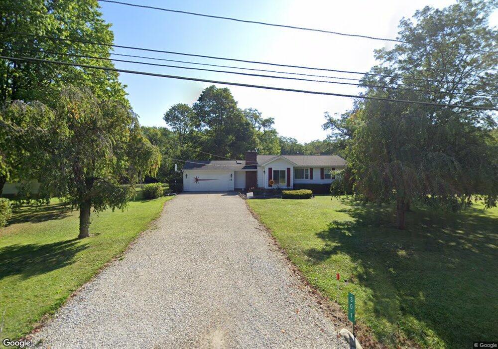
301 Substation Rd Brunswick, OH 44212
Estimated Value: $216,000 - $275,000
3
Beds
2
Baths
1,324
Sq Ft
$185/Sq Ft
Est. Value
About This Home
This home is located at 301 Substation Rd, Brunswick, OH 44212 and is currently estimated at $245,062, approximately $185 per square foot. 301 Substation Rd is a home located in Medina County with nearby schools including Brunswick Memorial Elementary School, Willets Middle School, and Brunswick High School.
Ownership History
Date
Name
Owned For
Owner Type
Purchase Details
Closed on
Oct 8, 2020
Sold by
Jindra William K and Jindra Leila May
Bought by
Jindra William K and Jindra Leila May
Current Estimated Value
Purchase Details
Closed on
Apr 19, 2005
Sold by
Jindra William and Jindra Barbara Jane
Bought by
Jindra William K
Home Financials for this Owner
Home Financials are based on the most recent Mortgage that was taken out on this home.
Original Mortgage
$100,000
Interest Rate
5.88%
Mortgage Type
Fannie Mae Freddie Mac
Purchase Details
Closed on
Jan 27, 1999
Sold by
Jindra William and Jindra Barbara
Bought by
Jindra William and Jindra Barbara Jane
Create a Home Valuation Report for This Property
The Home Valuation Report is an in-depth analysis detailing your home's value as well as a comparison with similar homes in the area
Home Values in the Area
Average Home Value in this Area
Purchase History
| Date | Buyer | Sale Price | Title Company |
|---|---|---|---|
| Jindra William K | -- | None Available | |
| Jindra William K | $125,000 | Os Title | |
| Jindra William | -- | -- |
Source: Public Records
Mortgage History
| Date | Status | Borrower | Loan Amount |
|---|---|---|---|
| Closed | Jindra William K | $100,000 |
Source: Public Records
Tax History Compared to Growth
Tax History
| Year | Tax Paid | Tax Assessment Tax Assessment Total Assessment is a certain percentage of the fair market value that is determined by local assessors to be the total taxable value of land and additions on the property. | Land | Improvement |
|---|---|---|---|---|
| 2024 | $3,196 | $56,640 | $17,260 | $39,380 |
| 2023 | $3,196 | $56,640 | $17,260 | $39,380 |
| 2022 | $3,035 | $56,640 | $17,260 | $39,380 |
| 2021 | $2,696 | $44,260 | $13,490 | $30,770 |
| 2020 | $2,449 | $44,260 | $13,490 | $30,770 |
| 2019 | $2,449 | $44,260 | $13,490 | $30,770 |
| 2018 | $2,112 | $36,730 | $10,210 | $26,520 |
| 2017 | $2,115 | $36,730 | $10,210 | $26,520 |
| 2016 | $2,113 | $36,730 | $10,210 | $26,520 |
| 2015 | $1,986 | $34,650 | $9,630 | $25,020 |
| 2014 | $1,981 | $34,650 | $9,630 | $25,020 |
| 2013 | $1,985 | $34,650 | $9,630 | $25,020 |
Source: Public Records
Map
Nearby Homes
- 4626 Ruby Ln
- 642 Topaz Ln
- 4893 Grafton Rd
- 4630 Brookstone Ct
- 261 Marlee Ct
- 5045 Grafton Rd
- 4949 Orchard Dr
- 573 Oakhurst Dr
- 5255 Cheyney Ln
- 626 Juniper Ln
- 4723 Baywood Dr
- 660 Marsh Way
- 5277 Spruce Pointe Ln
- 480 Bridge Pointe Ln
- 4913 Fallen Leaf Trail
- 4910 Fallen Leaf Trail
- 786 Pepperwood Dr
- 833 Substation Rd
- 841 Substation Rd
- 5046 Forestland Ct
- 289 Substation Rd
- 317 Substation Rd
- 307 Substation Rd
- 4804 Zachary Trail
- 298 Substation Rd
- 337 Substation Rd
- 282 Substation Rd
- 4788 Zachary Trail
- 4787 Zachary Trail
- 338 Substation Rd
- 247 Substation Rd
- 348 Substation Rd
- 247 Newport Cir
- 324 Substation Rd
- 237 Substation Rd
- 4781 Zachary Trail
- 4905 Cessna Ave
- 241 Newport Cir
- 4772 Zachary Trail
- 356 Substation Rd