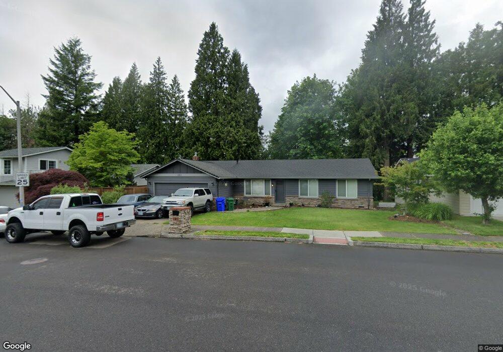
301 SW 4th St Gresham, OR 97080
Gresham Butte NeighborhoodEstimated Value: $422,000 - $448,000
3
Beds
2
Baths
1,196
Sq Ft
$361/Sq Ft
Est. Value
About This Home
This home is located at 301 SW 4th St, Gresham, OR 97080 and is currently estimated at $431,481, approximately $360 per square foot. 301 SW 4th St is a home located in Multnomah County with nearby schools including Dexter McCarty Middle School, Gresham High School, and Gresham Arthur Academy.
Ownership History
Date
Name
Owned For
Owner Type
Purchase Details
Closed on
Jan 4, 2005
Sold by
Owens William M
Bought by
Owens John M
Current Estimated Value
Home Financials for this Owner
Home Financials are based on the most recent Mortgage that was taken out on this home.
Original Mortgage
$128,000
Interest Rate
5.7%
Mortgage Type
Purchase Money Mortgage
Create a Home Valuation Report for This Property
The Home Valuation Report is an in-depth analysis detailing your home's value as well as a comparison with similar homes in the area
Home Values in the Area
Average Home Value in this Area
Purchase History
| Date | Buyer | Sale Price | Title Company |
|---|---|---|---|
| Owens John M | $160,000 | Lawyers Title Ins |
Source: Public Records
Mortgage History
| Date | Status | Borrower | Loan Amount |
|---|---|---|---|
| Closed | Owens John M | $128,000 |
Source: Public Records
Tax History
| Year | Tax Paid | Tax Assessment Tax Assessment Total Assessment is a certain percentage of the fair market value that is determined by local assessors to be the total taxable value of land and additions on the property. | Land | Improvement |
|---|---|---|---|---|
| 2025 | $4,576 | $224,890 | -- | -- |
| 2024 | $4,381 | $218,340 | -- | -- |
| 2023 | $3,991 | $211,990 | $0 | $0 |
| 2022 | $3,880 | $205,820 | $0 | $0 |
| 2021 | $3,782 | $199,830 | $0 | $0 |
| 2020 | $3,558 | $194,010 | $0 | $0 |
| 2019 | $3,465 | $188,360 | $0 | $0 |
| 2018 | $3,304 | $182,880 | $0 | $0 |
| 2017 | $3,170 | $177,560 | $0 | $0 |
| 2016 | $2,795 | $172,390 | $0 | $0 |
Source: Public Records
Map
Nearby Homes
- 625 SW Miller Ct
- 638 SW 7th St
- 645 W Powell Blvd
- 200 SW Florence Ave
- 419 SW Day Ct
- 417 SE Roberts Ave
- 159 SW Florence Ave Unit 64
- 159 SW Florence Ave
- 64 NW Florence Ave
- 318 NE Roberts Ave Unit 308
- 1113 W Powell Blvd
- 0 NE 5th St
- 55 SW Lovhar Dr
- 1333 SW 5th Place
- 420 SE Linden Ave
- 1434 SW 5th Place
- 0 SW Miller Ct Unit 470855683
- 1407 SE Beech Place
- 491 NE Elliott Ave
- 317 SW Angeline Ave
- 331 SW 4th St
- 291 SW 4th St
- 361 SW 4th St
- 340 SW 4th St
- 381 SW 4th St
- 370 SW 4th St
- 450 SW Victoria Ct
- 443 SW Victoria Ct
- 442 SW Eastman Ct
- 421 SW 4th St
- 480 SW Victoria Ct
- 483 SW Victoria Ct
- 462 SW Eastman Ct
- 430 SW 4th St
- 441 SW 4th St
- 445 SW Eastman Ct
- 500 SW Victoria Ct
- 503 SW Victoria Ct
- 502 SW Eastman Ct
Your Personal Tour Guide
Ask me questions while you tour the home.