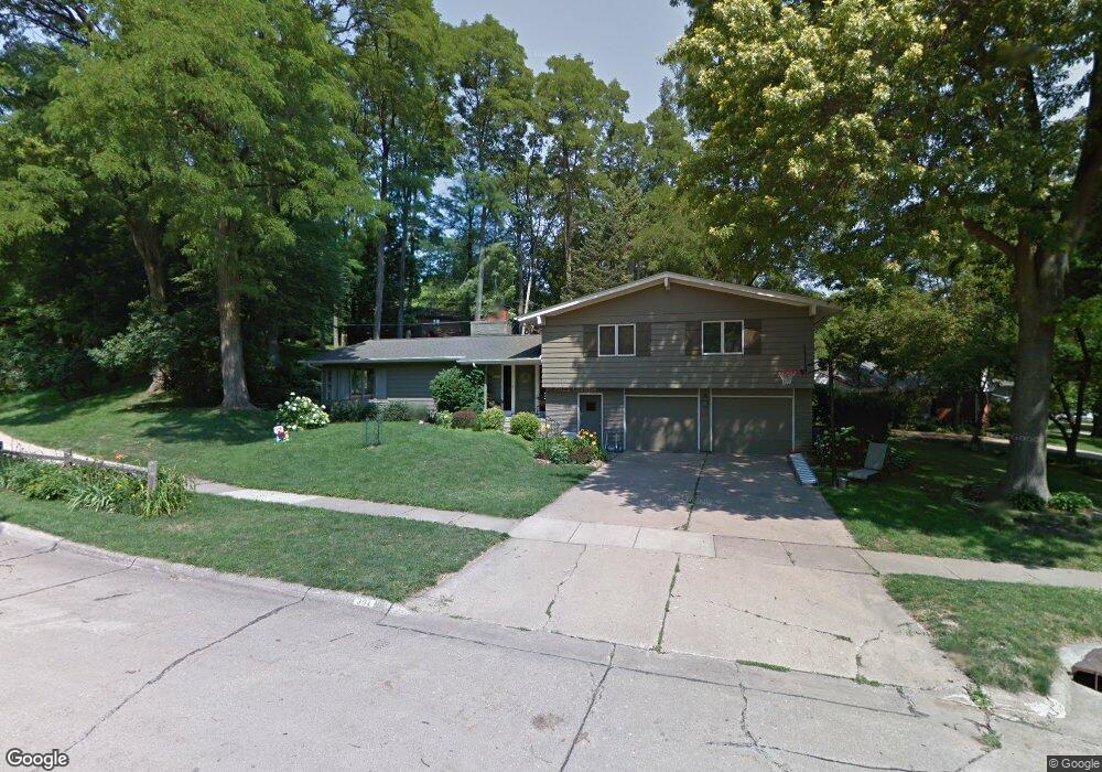
301 Thunderbird Rd SE Cedar Rapids, IA 52403
Estimated Value: $312,367 - $345,000
5
Beds
4
Baths
2,290
Sq Ft
$143/Sq Ft
Est. Value
About This Home
This home is located at 301 Thunderbird Rd SE, Cedar Rapids, IA 52403 and is currently estimated at $327,592, approximately $143 per square foot. 301 Thunderbird Rd SE is a home located in Linn County with nearby schools including Erskine Elementary School, McKinley STEAM Academy, and George Washington High School.
Ownership History
Date
Name
Owned For
Owner Type
Purchase Details
Closed on
Oct 31, 2003
Sold by
Tomsic Gregory W and Tomsic Melinda S
Bought by
Claassen Donald C and Claassen Trudy J
Current Estimated Value
Home Financials for this Owner
Home Financials are based on the most recent Mortgage that was taken out on this home.
Original Mortgage
$175,680
Outstanding Balance
$75,913
Interest Rate
5.25%
Mortgage Type
Unknown
Estimated Equity
$251,679
Create a Home Valuation Report for This Property
The Home Valuation Report is an in-depth analysis detailing your home's value as well as a comparison with similar homes in the area
Purchase History
| Date | Buyer | Sale Price | Title Company |
|---|---|---|---|
| Claassen Donald C | $219,500 | -- |
Source: Public Records
Mortgage History
| Date | Status | Borrower | Loan Amount |
|---|---|---|---|
| Open | Claassen Donald C | $175,680 |
Source: Public Records
Tax History
| Year | Tax Paid | Tax Assessment Tax Assessment Total Assessment is a certain percentage of the fair market value that is determined by local assessors to be the total taxable value of land and additions on the property. | Land | Improvement |
|---|---|---|---|---|
| 2025 | $4,650 | $298,500 | $50,000 | $248,500 |
| 2024 | $5,640 | $281,500 | $50,000 | $231,500 |
| 2023 | $5,640 | $280,200 | $50,000 | $230,200 |
| 2022 | $4,392 | $276,300 | $39,100 | $237,200 |
| 2021 | $5,274 | $221,000 | $39,100 | $181,900 |
| 2020 | $5,274 | $247,600 | $34,800 | $212,800 |
| 2019 | $4,698 | $226,500 | $34,800 | $191,700 |
Source: Public Records
Map
Nearby Homes
- 3618 Kegler Ct SE
- 237 34th St SE
- 501 36th St SE
- 2403 Kestrel Dr SE
- 2416 Kestrel Dr SE
- 2226 Kestrel Dr SE
- 3112 Peregrine Ct SE
- 2306 Kestrel Dr SE
- 2420 Kestrel Dr SE
- 2409 Kestrel Dr SE
- 2421 Kestrel Dr SE
- 2221 Kestrel Dr SE
- 2319 Kestrel Dr SE
- 2415 Kestrel Dr SE
- 2325 Kestrel Dr SE
- 2313 Kestrel Dr SE
- 2307 Kestrel Dr SE
- 2312 Kestrel Dr SE
- 2427 Kestrel Dr SE
- 3100 Peregrine Ct SE
- 295 Tomahawk Trail SE
- 3649 Honey Hill Dr SE
- 305 Tomahawk Trail SE
- 291 Tomahawk Trail SE
- 298 Thunderbird Rd SE
- 300 Tomahawk Trail SE
- 3640 Honey Hill Dr SE
- 3641 Honey Hill Dr SE
- 3810 Tomahawk Trail SE
- 287 Tomahawk Trail SE
- 294 Thunderbird Rd SE
- 3809 Tomahawk Trail SE
- 290 Tomahawk Trail SE
- 3820 Tomahawk Trail SE
- 3634 Honey Hill Dr SE
- 292 Thunderbird Rd SE
- 3813 Tomahawk Trail SE
- 283 Tomahawk Trail SE
- 291 Thunderbird Rd SE
- 3633 Honey Hill Dr SE
Your Personal Tour Guide
Ask me questions while you tour the home.