
Seller's Agent in 2025
Pennie Carroll
Pennie Carroll & Associates
(515) 490-8025
1,212 Total Sales

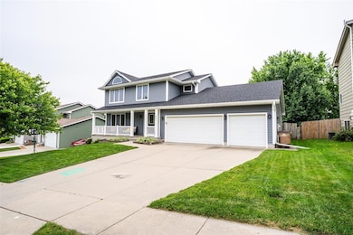
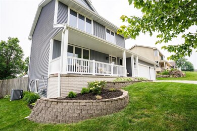
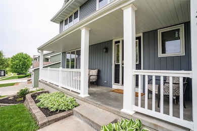

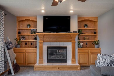
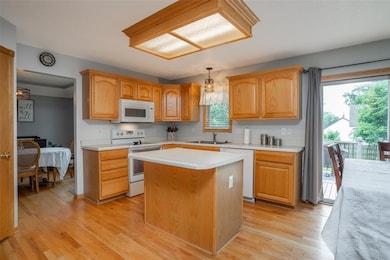
With six bedrooms, nearly 3000 sq. ft of finish, and a 4 car garage this Runnells beauty is a rare find! Located in the Southeast Polk School District, this home boasts updated roof(2024), siding(2020), water heater(2018), and HVAC(2016). After being greeted by a show stopper front porch, the main floor awaits you with an ample living room, formal dining room, large eat in kitchen with island and pantry, 1/2 bath, and comfortable family room with gas fireplace. Off the kitchen, check out the composite back deck for grilling out as you look over your fully fenced yard. Upstairs you'll find an expansive primary suite with vaulted ceilings, walk in closet, and ensuite full bath. Down the hall are 2 more large bedrooms with large closets, another full bath, and the convenience of an upstairs laundry room. The lower level WOWS with 3 more bedrooms, full bath, and a cozy rec room for games or movie nights. The 3 car garage with tandem 4th stall gives plenty of storage space. Come check it out!
| Date | Type | Sale Price | Title Company |
|---|---|---|---|
| Warranty Deed | $332,000 | None Listed On Document | |
| Warranty Deed | $332,000 | None Listed On Document | |
| Warranty Deed | $160,000 | None Available | |
| Warranty Deed | $181,000 | -- |
| Date | Status | Loan Amount | Loan Type |
|---|---|---|---|
| Open | $298,800 | New Conventional | |
| Closed | $298,800 | New Conventional | |
| Previous Owner | $144,000 | New Conventional | |
| Previous Owner | $172,300 | No Value Available |
| Date | Event | Price | List to Sale | Price per Sq Ft |
|---|---|---|---|---|
| 08/07/2025 08/07/25 | Sold | $332,000 | -0.9% | $165 / Sq Ft |
| 07/05/2025 07/05/25 | Pending | -- | -- | -- |
| 06/23/2025 06/23/25 | Price Changed | $335,000 | -2.0% | $167 / Sq Ft |
| 06/14/2025 06/14/25 | Price Changed | $342,000 | -2.0% | $170 / Sq Ft |
| 06/06/2025 06/06/25 | For Sale | $349,000 | -- | $173 / Sq Ft |
| Year | Tax Paid | Tax Assessment Tax Assessment Total Assessment is a certain percentage of the fair market value that is determined by local assessors to be the total taxable value of land and additions on the property. | Land | Improvement |
|---|---|---|---|---|
| 2025 | $4,754 | $311,000 | $33,700 | $277,300 |
| 2024 | $4,754 | $281,800 | $29,800 | $252,000 |
| 2023 | $4,540 | $281,800 | $29,800 | $252,000 |
| 2022 | $4,482 | $235,800 | $25,700 | $210,100 |
| 2021 | $4,204 | $235,800 | $25,700 | $210,100 |
| 2020 | $4,132 | $211,700 | $23,100 | $188,600 |
| 2019 | $4,004 | $211,700 | $23,100 | $188,600 |
| 2018 | $4,010 | $191,200 | $20,200 | $171,000 |
| 2017 | $4,136 | $191,200 | $20,200 | $171,000 |
| 2016 | $4,114 | $177,200 | $18,600 | $158,600 |
| 2015 | $4,114 | $177,200 | $18,600 | $158,600 |
| 2014 | $5,284 | $217,400 | $18,000 | $199,400 |
Seller's Agent in 2025
Pennie Carroll
Pennie Carroll & Associates
(515) 490-8025
1,212 Total Sales
Buyer's Agent in 2025
Jamie Adkins
RE/MAX
(515) 705-9994
51 Total Sales
Source: Des Moines Area Association of REALTORS®
MLS Number: 719613
APN: 161-00195005000
Disclaimer: Certain information contained herein is derived from information provided by parties other than Homes.com. All information provided is deemed reliable, but is not guaranteed to be accurate and should be independently verified.
![]() IDX information is provided exclusively for personal, non-commercial use, and may not be used for any purpose other than to identify prospective properties consumers may be interested in purchasing. Information is deemed reliable but not guaranteed.
IDX information is provided exclusively for personal, non-commercial use, and may not be used for any purpose other than to identify prospective properties consumers may be interested in purchasing. Information is deemed reliable but not guaranteed.
Ask me questions while you tour the home.