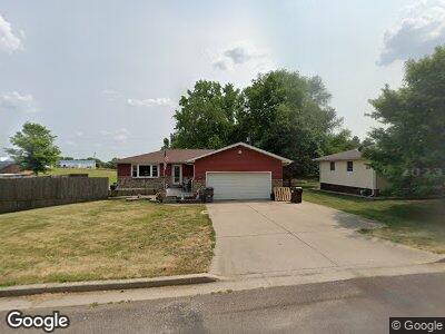
301 W Second St MacKinaw, IL 61755
Estimated Value: $167,000 - $187,000
3
Beds
2
Baths
1,120
Sq Ft
$159/Sq Ft
Est. Value
About This Home
This home is located at 301 W Second St, MacKinaw, IL 61755 and is currently estimated at $178,526, approximately $159 per square foot. 301 W Second St is a home located in Tazewell County with nearby schools including Dee-Mack Primary/Junior High School, Dee-Mack Intermediate School, and Dee-Mack High School.
Ownership History
Date
Name
Owned For
Owner Type
Purchase Details
Closed on
Aug 28, 2020
Sold by
Helmantoler William W
Bought by
Helmantoler Denise D
Current Estimated Value
Home Financials for this Owner
Home Financials are based on the most recent Mortgage that was taken out on this home.
Original Mortgage
$82,300
Interest Rate
2.9%
Mortgage Type
New Conventional
Create a Home Valuation Report for This Property
The Home Valuation Report is an in-depth analysis detailing your home's value as well as a comparison with similar homes in the area
Home Values in the Area
Average Home Value in this Area
Purchase History
| Date | Buyer | Sale Price | Title Company |
|---|---|---|---|
| Helmantoler Denise D | -- | Hometown Title Inc |
Source: Public Records
Mortgage History
| Date | Status | Borrower | Loan Amount |
|---|---|---|---|
| Closed | Helmantoler Denise D | $82,300 | |
| Closed | Helmantoler William W | $110,000 | |
| Closed | Helmantoler William W | $25,000 | |
| Closed | Helmantoler William W | $25,000 |
Source: Public Records
Tax History Compared to Growth
Tax History
| Year | Tax Paid | Tax Assessment Tax Assessment Total Assessment is a certain percentage of the fair market value that is determined by local assessors to be the total taxable value of land and additions on the property. | Land | Improvement |
|---|---|---|---|---|
| 2024 | $3,790 | $56,630 | $6,130 | $50,500 |
| 2023 | $3,790 | $52,090 | $5,640 | $46,450 |
| 2022 | $3,537 | $48,000 | $5,200 | $42,800 |
| 2021 | $3,413 | $46,150 | $5,000 | $41,150 |
| 2020 | $3,330 | $44,800 | $4,850 | $39,950 |
| 2019 | $3,341 | $44,800 | $4,850 | $39,950 |
| 2018 | $3,307 | $44,800 | $4,850 | $39,950 |
| 2017 | $3,259 | $44,350 | $4,800 | $39,550 |
| 2016 | $3,224 | $44,350 | $4,800 | $39,550 |
| 2015 | $2,976 | $0 | $0 | $0 |
| 2013 | $2,771 | $42,150 | $6,570 | $35,580 |
Source: Public Records
Map
Nearby Homes
- 301 S Orchard St
- 205 N Orchard St
- 213 Tulip Dr
- 357 Heritage Dr
- 45 Roxbury Dr Unit VI
- 801 Heritage Dr
- 723 Heritage Dr
- 525 Heritage Dr
- 1398 Fairfax Ct
- 103 E 1400 Rd N
- 10425 Northpoint Rd
- 18196 River Rd
- 1205 Whippoorwill Dr
- 535 E Queenwood Rd
- 50 Lincoln Ct
- 1248 E Monroe St
- 1066 E Jefferson St
- 301 S Harris St
- 1808 Deerfield Dr
- 67 N Oregon Ave
- 301 W Second St
- 303 W 2nd St
- 303 W Second St
- 205 W Second St
- 502 S Tazewell Ave
- 305 W Second St
- 305 W 2nd St
- 603 S Tazewell St
- 600 S Tazewell Ave
- 503 S Tazewell Ave
- 203 W Second St
- 307 W 2nd St
- 307 W Second St
- 200 W Second St
- 413 Stout Dr
- 501 S Tazewell Ave
- 203 W Third St
- 411 Stout Dr
- 602 S Monroe St