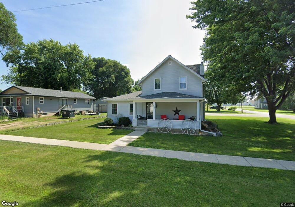
302 N 2nd St Sheffield, IA 50475
Estimated Value: $134,000 - $165,941
3
Beds
1
Bath
1,304
Sq Ft
$114/Sq Ft
Est. Value
About This Home
This home is located at 302 N 2nd St, Sheffield, IA 50475 and is currently estimated at $149,235, approximately $114 per square foot. 302 N 2nd St is a home located in Franklin County with nearby schools including West Fork High School.
Ownership History
Date
Name
Owned For
Owner Type
Purchase Details
Closed on
Apr 20, 2023
Sold by
Barnes Martin J and Barnes Debra L
Bought by
Nuehring Madison M and Nuehring Carter W
Current Estimated Value
Home Financials for this Owner
Home Financials are based on the most recent Mortgage that was taken out on this home.
Original Mortgage
$152,192
Outstanding Balance
$148,062
Interest Rate
6.73%
Mortgage Type
FHA
Estimated Equity
$1,173
Create a Home Valuation Report for This Property
The Home Valuation Report is an in-depth analysis detailing your home's value as well as a comparison with similar homes in the area
Home Values in the Area
Average Home Value in this Area
Purchase History
| Date | Buyer | Sale Price | Title Company |
|---|---|---|---|
| Nuehring Madison M | $155,000 | None Listed On Document |
Source: Public Records
Mortgage History
| Date | Status | Borrower | Loan Amount |
|---|---|---|---|
| Open | Nuehring Madison M | $152,192 |
Source: Public Records
Tax History Compared to Growth
Tax History
| Year | Tax Paid | Tax Assessment Tax Assessment Total Assessment is a certain percentage of the fair market value that is determined by local assessors to be the total taxable value of land and additions on the property. | Land | Improvement |
|---|---|---|---|---|
| 2025 | $2,136 | $135,400 | $11,800 | $123,600 |
| 2024 | $2,136 | $132,400 | $11,800 | $120,600 |
| 2023 | $2,022 | $122,400 | $11,800 | $110,600 |
| 2022 | $1,642 | $111,800 | $11,800 | $100,000 |
| 2021 | $1,097 | $88,600 | $11,800 | $76,800 |
| 2020 | $1,322 | $85,400 | $11,800 | $73,600 |
| 2019 | $1,228 | $73,600 | $0 | $0 |
| 2018 | $1,182 | $73,600 | $0 | $0 |
| 2017 | $1,178 | $72,100 | $0 | $0 |
| 2016 | $1,180 | $72,100 | $0 | $0 |
| 2015 | $1,180 | $72,100 | $0 | $0 |
| 2014 | $1,178 | $72,100 | $0 | $0 |
Source: Public Records
Map
Nearby Homes
- 222 Thompson St
- 319 N 6th St
- 421 Sherman St
- 119 N 6th St
- 601 Gilman St
- 608 Sherman St
- 319 S Lincoln St
- 202 Brickyard Ct
- 206 Brickyard Ct
- 200 Brickyard Ct
- 602 Claydigger Run
- 410 Brickyard Rd
- 409 Brickyard Rd
- 421 Brickyard Rd
- 417 Brickyard Rd
- 419 Brickyard Rd
- 411 Brickyard Rd
- 415 Brickyard Rd
- 423 Brickyard Rd
- 427 Brickyard Rd