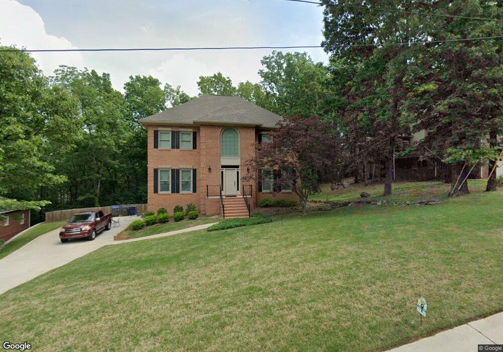
302 Newgate Ct Alabaster, AL 35007
Estimated Value: $389,000 - $428,000
Studio
2
Baths
2,786
Sq Ft
$144/Sq Ft
Est. Value
About This Home
This home is located at 302 Newgate Ct, Alabaster, AL 35007 and is currently estimated at $400,894, approximately $143 per square foot. 302 Newgate Ct is a home located in Shelby County with nearby schools including Thompson Intermediate School, Thompson Middle School, and Thompson High School.
Ownership History
Date
Name
Owned For
Owner Type
Purchase Details
Closed on
Dec 16, 2010
Sold by
Kane Tommy L and Kane Patricia E
Bought by
Kane Tommy L and Kane Patricia E
Current Estimated Value
Home Financials for this Owner
Home Financials are based on the most recent Mortgage that was taken out on this home.
Original Mortgage
$119,000
Outstanding Balance
$80,986
Interest Rate
4.82%
Mortgage Type
New Conventional
Estimated Equity
$319,908
Purchase Details
Closed on
Sep 25, 1998
Sold by
Beaty Warner Richard
Bought by
Kane T L and Kane P
Home Financials for this Owner
Home Financials are based on the most recent Mortgage that was taken out on this home.
Original Mortgage
$145,500
Interest Rate
6.96%
Create a Home Valuation Report for This Property
The Home Valuation Report is an in-depth analysis detailing your home's value as well as a comparison with similar homes in the area
Home Values in the Area
Average Home Value in this Area
Purchase History
| Date | Buyer | Sale Price | Title Company |
|---|---|---|---|
| Kane Tommy L | -- | None Available | |
| Kane T L | $181,900 | Alabama Title Co Inc |
Source: Public Records
Mortgage History
| Date | Status | Borrower | Loan Amount |
|---|---|---|---|
| Open | Kane Tommy L | $119,000 | |
| Closed | Kane T L | $145,500 |
Source: Public Records
Tax History
| Year | Tax Paid | Tax Assessment Tax Assessment Total Assessment is a certain percentage of the fair market value that is determined by local assessors to be the total taxable value of land and additions on the property. | Land | Improvement |
|---|---|---|---|---|
| 2024 | $1,919 | $35,540 | $0 | $0 |
| 2023 | $1,729 | $32,780 | $0 | $0 |
| 2022 | $1,589 | $30,180 | $0 | $0 |
| 2021 | $1,435 | $27,340 | $0 | $0 |
| 2020 | $1,349 | $0 | $0 | $0 |
| 2019 | $1,309 | $25,000 | $0 | $0 |
| 2017 | $1,330 | $25,380 | $0 | $0 |
| 2015 | $1,281 | $24,480 | $0 | $0 |
| 2014 | $1,250 | $23,900 | $0 | $0 |
Source: Public Records
Map
Nearby Homes
- 537 Ramsgate Dr
- 280 Cedar Grove Pkwy
- 306 Mayfair Cir
- 309 Cedar Grove Ct
- 305 Cedar Grove Ct
- 312 Cornwall Dr
- 124 Kingsley Rd
- 445 Ramsgate Dr
- 545 Ramsgate Dr
- 544 Ramsgate Dr
- 549 Ramsgate Dr
- 316 Sterling Manor Cir
- 120 Mayfair Park
- 236 Queens Gate
- 521 13th St SW
- 1307 3rd Ave SW
- 120 Sterling Gate Dr
- 208 Queens Gate
- 501 Ramsgate Dr
- 2001 1st Ave W
- 304 Newgate Ct
- 204 Newgate Cir
- 202 Newgate Cir
- 234 Norwick Forest Dr
- 306 Newgate Ct
- 303 Newgate Ct
- 301 Newgate Ct
- 305 Newgate Ct
- 113 Newgate Rd
- 236 Norwick Forest Dr
- 203 Newgate Cir
- 307 Newgate Ct
- 111 Newgate Rd
- 115 Newgate Rd
- 205 Newgate Cir
- 228 Norwick Forest Dr
- 0 Norwick Forest Dr Unit 44
- 224 Norwick Forest Dr Unit 3/47
- 232 Norwick Forest Dr Unit 3/43
- 228 Norwick Forest Dr Unit 3/45
Your Personal Tour Guide
Ask me questions while you tour the home.