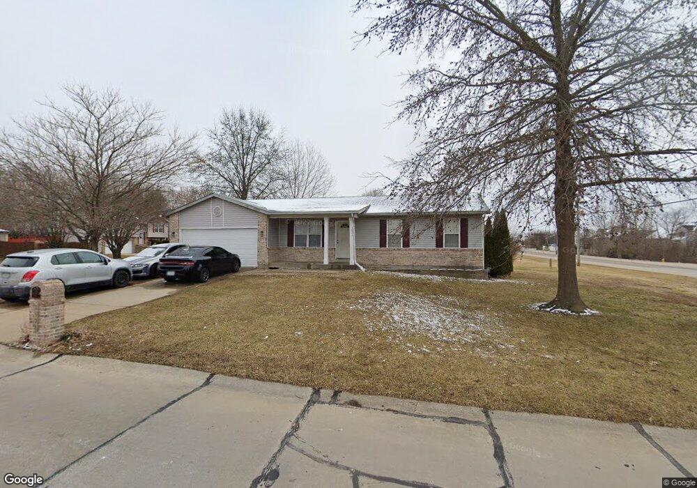
3026 Long Wheat Dr O Fallon, MO 63368
Estimated Value: $288,000 - $323,000
3
Beds
2
Baths
1,268
Sq Ft
$240/Sq Ft
Est. Value
About This Home
This home is located at 3026 Long Wheat Dr, O Fallon, MO 63368 and is currently estimated at $304,591, approximately $240 per square foot. 3026 Long Wheat Dr is a home located in St. Charles County with nearby schools including Pheasant Point Elementary School, Fort Zumwalt South Middle School, and Fort Zumwalt South High School.
Ownership History
Date
Name
Owned For
Owner Type
Purchase Details
Closed on
Jun 14, 2006
Sold by
Nolting David and Nolting Frances
Bought by
Nolting David L and Nolting Frances
Current Estimated Value
Home Financials for this Owner
Home Financials are based on the most recent Mortgage that was taken out on this home.
Original Mortgage
$146,400
Outstanding Balance
$98,221
Interest Rate
9.25%
Mortgage Type
Purchase Money Mortgage
Estimated Equity
$206,370
Purchase Details
Closed on
Feb 10, 2006
Sold by
Nolting David L and Nolting Frances J
Bought by
Nolting David L and Nolting Frances J
Purchase Details
Closed on
Jul 27, 2000
Sold by
Green Billy R and Green Carla J
Bought by
Nolting David L
Create a Home Valuation Report for This Property
The Home Valuation Report is an in-depth analysis detailing your home's value as well as a comparison with similar homes in the area
Home Values in the Area
Average Home Value in this Area
Purchase History
| Date | Buyer | Sale Price | Title Company |
|---|---|---|---|
| Nolting David L | -- | Archway Title Agency Inc | |
| Nolting David L | -- | None Available | |
| Nolting David L | -- | -- |
Source: Public Records
Mortgage History
| Date | Status | Borrower | Loan Amount |
|---|---|---|---|
| Open | Nolting David L | $146,400 |
Source: Public Records
Tax History
| Year | Tax Paid | Tax Assessment Tax Assessment Total Assessment is a certain percentage of the fair market value that is determined by local assessors to be the total taxable value of land and additions on the property. | Land | Improvement |
|---|---|---|---|---|
| 2025 | $3,154 | $52,570 | -- | -- |
| 2023 | $3,157 | $47,784 | $0 | $0 |
| 2022 | $2,534 | $35,676 | $0 | $0 |
| 2021 | $2,541 | $35,676 | $0 | $0 |
| 2020 | $2,472 | $33,433 | $0 | $0 |
| 2019 | $2,478 | $33,433 | $0 | $0 |
| 2018 | $2,350 | $30,324 | $0 | $0 |
| 2017 | $2,309 | $30,324 | $0 | $0 |
| 2016 | $2,136 | $26,938 | $0 | $0 |
| 2015 | $1,991 | $26,938 | $0 | $0 |
| 2014 | $1,944 | $25,944 | $0 | $0 |
Source: Public Records
Map
Nearby Homes
- 1130 Spring Orchard Dr
- 178 Christina Marie Dr
- 26 Dalton Valley Dr
- 249 Dardenne Farms Dr
- 661 Clifton Hill Dr
- 12 McCluer Ct
- 10 Muir Trail Ct
- 1319 Commons Cir
- 3 Royallbend Ct
- 2726 Brook Meadow Ln
- 9007 Camino Trail
- 611 Bennington Dr
- 93 Arapahoe Basin Ct
- 367 Shamrock St
- 361 Shamrock St
- 8019 Cotswald Trail
- 6025 Mo-N Unit # 1
- 8032 Cotswald Trail
- 6024 Mo-N Unit #2
- 262 Royallsprings Pkwy
- 6436 Long Timber Dr
- 3022 Long Wheat Dr
- 6500 Long Timber Dr
- 6432 Long Timber Dr
- 6437 Long Timber Dr
- 6501 Long Timber Dr
- 6433 Long Timber Dr
- 6504 Long Timber Dr
- 6428 Long Timber Dr
- 6442 Star Buck Dr
- 6505 Long Timber Dr
- 6438 Star Buck Dr
- 6429 Long Timber Dr
- 3017 Long Wheat Dr
- 6508 Long Timber Dr
- 6434 Star Buck Dr
- 6424 Long Timber Dr
- 6509 Long Timber Dr
- 6425 Long Timber Dr
- 6506 Star Buck Dr
Your Personal Tour Guide
Ask me questions while you tour the home.