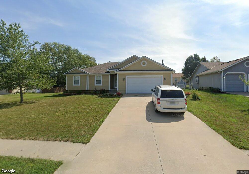
303 Leah Ln Harrisonville, MO 64701
Estimated Value: $318,635 - $346,000
3
Beds
2
Baths
1,681
Sq Ft
$196/Sq Ft
Est. Value
About This Home
This home is located at 303 Leah Ln, Harrisonville, MO 64701 and is currently estimated at $328,659, approximately $195 per square foot. 303 Leah Ln is a home located in Cass County with nearby schools including Harrisonville Elementary School, McEowen Elementary School, and Harrisonville Middle School.
Ownership History
Date
Name
Owned For
Owner Type
Purchase Details
Closed on
Mar 11, 2005
Sold by
Custom Framing Inc
Bought by
Hutchinson Robert D and Hutchinson Sara K
Current Estimated Value
Home Financials for this Owner
Home Financials are based on the most recent Mortgage that was taken out on this home.
Original Mortgage
$131,920
Outstanding Balance
$67,323
Interest Rate
5.71%
Mortgage Type
New Conventional
Estimated Equity
$261,336
Create a Home Valuation Report for This Property
The Home Valuation Report is an in-depth analysis detailing your home's value as well as a comparison with similar homes in the area
Home Values in the Area
Average Home Value in this Area
Purchase History
| Date | Buyer | Sale Price | Title Company |
|---|---|---|---|
| Hutchinson Robert D | -- | -- |
Source: Public Records
Mortgage History
| Date | Status | Borrower | Loan Amount |
|---|---|---|---|
| Open | Hutchinson Robert D | $131,920 |
Source: Public Records
Tax History Compared to Growth
Tax History
| Year | Tax Paid | Tax Assessment Tax Assessment Total Assessment is a certain percentage of the fair market value that is determined by local assessors to be the total taxable value of land and additions on the property. | Land | Improvement |
|---|---|---|---|---|
| 2024 | $2,623 | $38,850 | $4,190 | $34,660 |
| 2023 | $2,608 | $38,850 | $4,190 | $34,660 |
| 2022 | $2,294 | $33,790 | $4,190 | $29,600 |
| 2021 | $2,294 | $33,790 | $4,190 | $29,600 |
| 2020 | $2,241 | $33,100 | $4,190 | $28,910 |
| 2019 | $2,075 | $33,100 | $4,190 | $28,910 |
| 2018 | $1,890 | $29,910 | $3,690 | $26,220 |
| 2017 | $1,804 | $29,910 | $3,690 | $26,220 |
| 2016 | $1,804 | $28,340 | $3,690 | $24,650 |
| 2015 | $1,770 | $27,800 | $3,690 | $24,110 |
| 2014 | $1,771 | $27,800 | $3,690 | $24,110 |
| 2013 | -- | $27,800 | $3,690 | $24,110 |
Source: Public Records
Map
Nearby Homes
- 304 Andrea Ln
- 517 Village Ln
- 2618 Meadowlark Dr
- 104 Brookridge Dr
- 616 Silver Maple Dr
- 909 Mission Dr
- 705 Galaxie Ave
- 2203 Twin Oaks Dr
- 2500 Twin Oaks Dr
- 1001 Twin Oaks Terrace
- 2201 Twin Oaks Dr
- 1003 Twin Oaks Terrace
- 902 Twin Oaks Terrace
- 904 Twin Oaks Terrace
- 2203 Mission Rd
- 1000 Twin Oaks Terrace
- 1002 Twin Oaks Terrace
- 2205 Mission Rd
- 2004 Maverick Trail
- 2200 Mission Rd