
Seller's Agent in 2025
James Nay
River City Elite Properties - Real Broker
(804) 704-1944
4 in this area
948 Total Sales
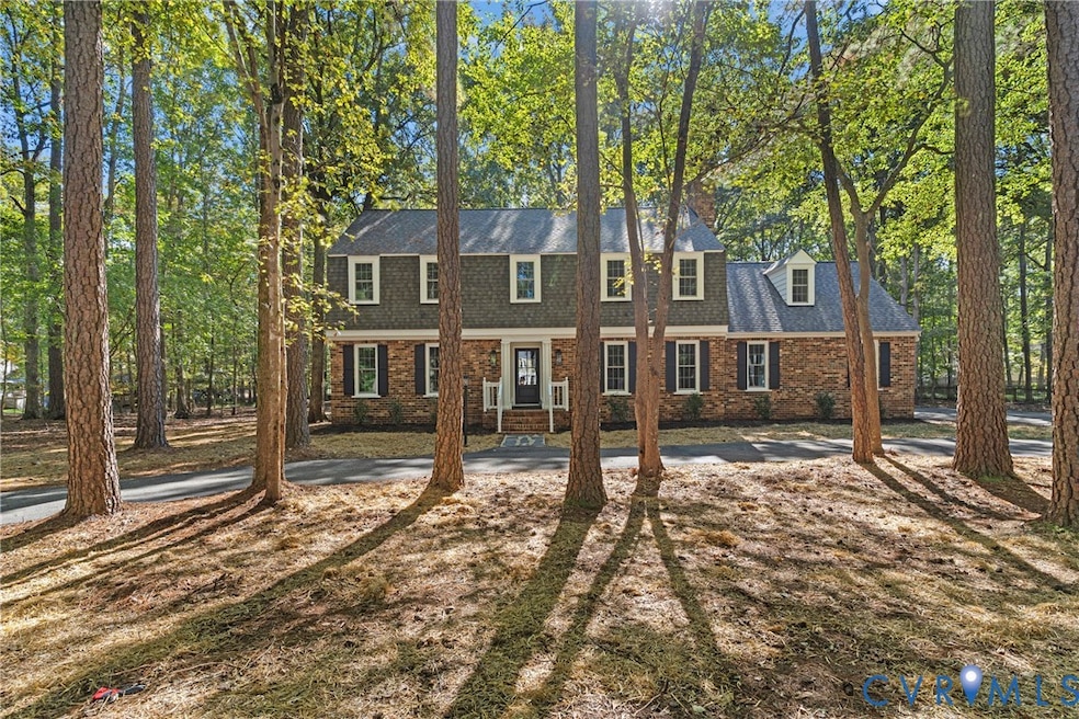


You're going to LOVE this FULLY RENOVATED 4 bedroom, 2.5 bath, 3,000 sqft home with a side-load 2.5-car garage on a 1 acre lot in the highly sought-after Salisbury neighborhood of Midlothian! As you pull into the paved loop driveway, you're met with a stunning front elevation, NEW windows (2025), NEW Therma-Tru exterior doors (2025), fresh landscaping, NEW insulated garage doors (2025), Newer roof (2024) & tons of curb appeal. Walking in you're greeted w/ NEW herringbone-pattern tile flooring in the foyer & NEW hardwood floors flow throughout the whole first floor! To your left is the formal living room w/ crown & chair rail moldings. The dining room features a decorative chandelier, chair rail & crown moulding and is completely open to the chef's kitchen. The kitchen offers NEW true wood soft-close cabinetry, NEW marble counters, NEW Frigidaire stainless appliances, a 6 foot island w/ waterfall countertops, Built-in wine bar w/ wine cooler, pot filler faucet, Custom Hood, under cabinet lighting, pendant lighting, built-in pantry cabinets & an eat-in area. The family room has a gas fireplace w/ brick surround, hardwoods, built-ins & gorgeous exposed beams. Rounding out the first floor is the fully updated half bath & Florida room w/ NEW herringbone LVP flooring, New ceiling fan, chair & crown moulding. The massive three tier back deck offers tons of outdoor entertaining space w/ built-in bench seating & is freshly painted! Upstairs, you'll find the primary suite w/ hardwood flooring, a walk-in closet, ensuite bath w/ heated floors, NEW tiled shower w/ a glass enclosure & NEW double sink vanity. Off of the primary is a 5th bedroom/bonus room w/ NEW carpet & fresh paint! There are 3 additional bedrooms w/ NEW carpet, Fresh Paint & New lighting. The updated full hall bath showcases a NEW custom 8 foot double sink vanity, tile flooring & a tile shower surround. Wrapping up the second floor is the laundry room. Features; NEW 4 ton carrier HVAC (2025), NEW Water Heater (2025), NEW Vapor Barrier (2025) & so much more!
Last Agent to Sell the Property
River City Elite Properties - Real Broker License #0225221595 Listed on: 10/12/2025
| Date | Type | Sale Price | Title Company |
|---|---|---|---|
| Deed | $500,000 | Fidelity National Title | |
| Deed Of Distribution | -- | -- | |
| Warranty Deed | -- | -- |
| Date | Status | Loan Amount | Loan Type |
|---|---|---|---|
| Previous Owner | $180,000 | New Conventional |
| Date | Event | Price | List to Sale | Price per Sq Ft |
|---|---|---|---|---|
| 11/07/2025 11/07/25 | Sold | $767,500 | +4.4% | $261 / Sq Ft |
| 10/18/2025 10/18/25 | Pending | -- | -- | -- |
| 10/16/2025 10/16/25 | For Sale | $735,000 | -- | $250 / Sq Ft |
| Year | Tax Paid | Tax Assessment Tax Assessment Total Assessment is a certain percentage of the fair market value that is determined by local assessors to be the total taxable value of land and additions on the property. | Land | Improvement |
|---|---|---|---|---|
| 2025 | $5,440 | $608,400 | $131,000 | $477,400 |
| 2024 | $5,440 | $567,700 | $111,000 | $456,700 |
| 2023 | $4,855 | $533,500 | $106,000 | $427,500 |
| 2022 | $4,658 | $506,300 | $103,000 | $403,300 |
| 2021 | $4,446 | $461,100 | $101,000 | $360,100 |
| 2020 | $4,231 | $445,400 | $101,000 | $344,400 |
| 2019 | $4,231 | $445,400 | $101,000 | $344,400 |
| 2018 | $4,049 | $426,200 | $101,000 | $325,200 |
| 2017 | $3,928 | $409,200 | $100,000 | $309,200 |
| 2016 | $3,863 | $402,400 | $96,000 | $306,400 |
| 2015 | $3,757 | $388,700 | $96,000 | $292,700 |
| 2014 | $3,625 | $375,000 | $96,000 | $279,000 |
Seller's Agent in 2025
James Nay
River City Elite Properties - Real Broker
(804) 704-1944
4 in this area
948 Total Sales
Buyer's Agent in 2025
Taylor Jefferson
Compass
(804) 357-8490
3 in this area
203 Total Sales
Source: Central Virginia Regional MLS
MLS Number: 2528721
APN: 727-71-93-17-700-000
Disclaimer: Certain information contained herein is derived from information provided by parties other than Homes.com. All information provided is deemed reliable, but is not guaranteed to be accurate and should be independently verified.
![]() All or a portion of th multiple Listing information is provided by the Central Virginia Regional Multiple Listing Service, LLC, from a copyrighted compilation of Listing s. All CVR MLS information provided is deemed reliable but is not guaranteed accurate. The compilation of Listings and each individual Listing are ©2026 Central Virginia Regional Multiple Listing Service, LLC. All rights reserved.
All or a portion of th multiple Listing information is provided by the Central Virginia Regional Multiple Listing Service, LLC, from a copyrighted compilation of Listing s. All CVR MLS information provided is deemed reliable but is not guaranteed accurate. The compilation of Listings and each individual Listing are ©2026 Central Virginia Regional Multiple Listing Service, LLC. All rights reserved.
Ask me questions while you tour the home.