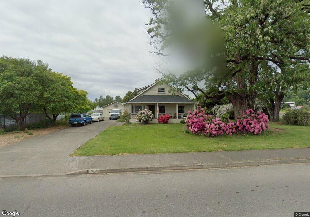
304 E Scott Ave Woodland, WA 98674
Estimated Value: $493,110 - $582,000
4
Beds
2
Baths
2,258
Sq Ft
$243/Sq Ft
Est. Value
About This Home
This home is located at 304 E Scott Ave, Woodland, WA 98674 and is currently estimated at $548,028, approximately $242 per square foot. 304 E Scott Ave is a home located in Cowlitz County with nearby schools including Woodland High School.
Ownership History
Date
Name
Owned For
Owner Type
Purchase Details
Closed on
Aug 25, 2025
Sold by
Roy Siddhartha and Roy Codi R
Bought by
Roy Family Trust and Roy
Current Estimated Value
Purchase Details
Closed on
Feb 7, 2017
Sold by
Glidden Cora V
Bought by
Roy Siddhartha and Roy Codi R
Home Financials for this Owner
Home Financials are based on the most recent Mortgage that was taken out on this home.
Original Mortgage
$251,750
Interest Rate
4.2%
Mortgage Type
New Conventional
Create a Home Valuation Report for This Property
The Home Valuation Report is an in-depth analysis detailing your home's value as well as a comparison with similar homes in the area
Home Values in the Area
Average Home Value in this Area
Purchase History
| Date | Buyer | Sale Price | Title Company |
|---|---|---|---|
| Roy Family Trust | -- | None Listed On Document | |
| Roy Siddhartha | $265,000 | Cowlitz County Title Company |
Source: Public Records
Mortgage History
| Date | Status | Borrower | Loan Amount |
|---|---|---|---|
| Previous Owner | Roy Siddhartha | $251,750 |
Source: Public Records
Tax History Compared to Growth
Tax History
| Year | Tax Paid | Tax Assessment Tax Assessment Total Assessment is a certain percentage of the fair market value that is determined by local assessors to be the total taxable value of land and additions on the property. | Land | Improvement |
|---|---|---|---|---|
| 2024 | $4,498 | $408,080 | $86,900 | $321,180 |
| 2023 | $3,513 | $403,460 | $86,900 | $316,560 |
| 2022 | $3,934 | $383,410 | $86,900 | $296,510 |
| 2021 | $4,030 | $333,470 | $79,000 | $254,470 |
| 2020 | $3,532 | $311,300 | $57,250 | $254,050 |
| 2019 | $3,117 | $272,542 | $57,251 | $215,291 |
| 2018 | $3,052 | $270,410 | $57,250 | $213,160 |
| 2017 | $2,610 | $232,830 | $57,250 | $175,580 |
| 2016 | $2,432 | $205,030 | $53,010 | $152,020 |
| 2015 | $2,373 | $187,960 | $53,010 | $134,950 |
| 2013 | -- | $161,780 | $47,590 | $114,190 |
Source: Public Records
Map
Nearby Homes
- 9565 Old Pacific Hwy
- 1776 Clover Ln
- 275 Sycamore St
- 1850 Heartwood Dr
- 442 Washington St
- 1786 Clatsop St
- 4130 Green Mountain Rd
- 600 Cc St
- 1833 Hawthorne Ct
- 229 Cc St
- 39806 NW 64th Ct
- 841 Washington St
- 336 York St
- 1986 Meadowood Loop
- 221 Valley Way
- 284 Gun Club Rd
- 2009 Lewis River Rd Unit 17
- 2009 Lewis River Rd Unit 24
- 766 Hoffman St
- 234 Loves Ave
- 360 Hollyberry St
- 115 Meadow Park Ct
- 125 Meadow Park Ct
- 265 E Scott Ave
- 387 E Scott Ave
- 340 Hollyberry St
- 135 Meadow Park Ct
- 110 Meadow Park Ct
- 175 Peach Tree Ct
- 120 Meadow Park Ct
- 411 E Scott Ave
- 165 Peach Tree Ct
- 155 Meadow Park Ct
- 330 Hollyberry St
- 145 Meadow Park Ct
- 250 E Scott Ave
- 155 Peach Tree Ct
- 130 Meadow Park Ct
- 345 Hollyberry St
- 165 Meadow Park Ct