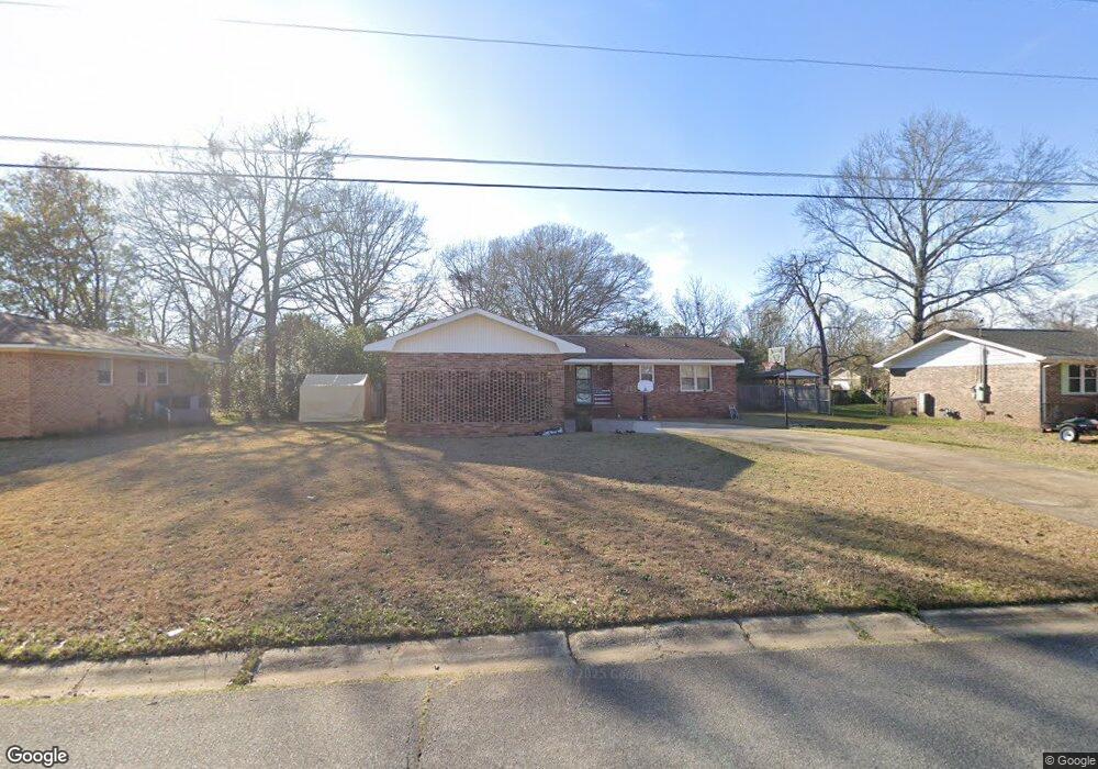
304 Emory Dr Warner Robins, GA 31093
Estimated Value: $187,975 - $199,000
3
Beds
2
Baths
1,556
Sq Ft
$124/Sq Ft
Est. Value
About This Home
This home is located at 304 Emory Dr, Warner Robins, GA 31093 and is currently estimated at $192,494, approximately $123 per square foot. 304 Emory Dr is a home located in Houston County with nearby schools including Parkwood Elementary School, Northside Middle School, and Northside High School.
Ownership History
Date
Name
Owned For
Owner Type
Purchase Details
Closed on
Dec 10, 2008
Sold by
Graham Sparkle C and Bryant Jenny L
Bought by
Wilder Anton and Gruber Crystal L
Current Estimated Value
Home Financials for this Owner
Home Financials are based on the most recent Mortgage that was taken out on this home.
Original Mortgage
$92,000
Outstanding Balance
$61,527
Interest Rate
6.38%
Mortgage Type
Purchase Money Mortgage
Estimated Equity
$130,967
Purchase Details
Closed on
Dec 19, 2000
Sold by
Hisaw Bobbie J and Hisaw Betty L
Bought by
Graham Sparkle C
Purchase Details
Closed on
Nov 24, 1976
Sold by
Day Easton
Bought by
Hisaw Bobbie J and Hisaw Betty L
Purchase Details
Closed on
Apr 4, 1974
Sold by
Williams John Burnard
Bought by
Day Easton
Purchase Details
Closed on
Mar 20, 1974
Sold by
Materpiece Enterprises Inc
Bought by
Williams John Burnard
Purchase Details
Closed on
Jun 26, 1973
Sold by
Shamrock Dev Inc
Bought by
Materpiece Enterprises Inc
Create a Home Valuation Report for This Property
The Home Valuation Report is an in-depth analysis detailing your home's value as well as a comparison with similar homes in the area
Home Values in the Area
Average Home Value in this Area
Purchase History
| Date | Buyer | Sale Price | Title Company |
|---|---|---|---|
| Wilder Anton | $92,000 | None Available | |
| Graham Sparkle C | $81,500 | -- | |
| Hisaw Bobbie J | -- | -- | |
| Day Easton | -- | -- | |
| Williams John Burnard | -- | -- | |
| Materpiece Enterprises Inc | -- | -- |
Source: Public Records
Mortgage History
| Date | Status | Borrower | Loan Amount |
|---|---|---|---|
| Open | Wilder Anton | $92,000 |
Source: Public Records
Tax History
| Year | Tax Paid | Tax Assessment Tax Assessment Total Assessment is a certain percentage of the fair market value that is determined by local assessors to be the total taxable value of land and additions on the property. | Land | Improvement |
|---|---|---|---|---|
| 2024 | $1,605 | $50,440 | $8,000 | $42,440 |
| 2023 | $1,318 | $41,360 | $8,000 | $33,360 |
| 2022 | $789 | $36,320 | $5,400 | $30,920 |
| 2021 | $688 | $31,760 | $5,400 | $26,360 |
| 2020 | $678 | $31,200 | $5,400 | $25,800 |
| 2019 | $678 | $31,200 | $5,400 | $25,800 |
| 2018 | $678 | $31,200 | $5,400 | $25,800 |
| 2017 | $679 | $31,200 | $5,400 | $25,800 |
| 2016 | $680 | $31,200 | $5,400 | $25,800 |
| 2015 | -- | $31,200 | $5,400 | $25,800 |
| 2014 | -- | $31,200 | $5,400 | $25,800 |
| 2013 | -- | $35,040 | $5,400 | $29,640 |
Source: Public Records
Map
Nearby Homes
- 317 Emory Dr
- 208 Pellimore Dr
- 305 Norman Ln
- 112 Emory Dr
- 203 Gawin Dr
- 302 Kensington Cir
- 145 Kensington Cir
- 156 Red Birch Ln
- 118 Red Birch Ln
- 136 Red Birch Ln
- 156 Martin Mill Trail
- 414 Forest Lake Dr
- 116 Kensington Cir
- 110 Mitchell Ct
- 201 Eagles Landing Trail
- 123 Tanglewood Dr
- 110 Foxfire Dr
- 105 Mitchell Ct
- 94 Tiffany Ln
- 0 N Houston Rd Unit Northlake Dr.
Your Personal Tour Guide
Ask me questions while you tour the home.