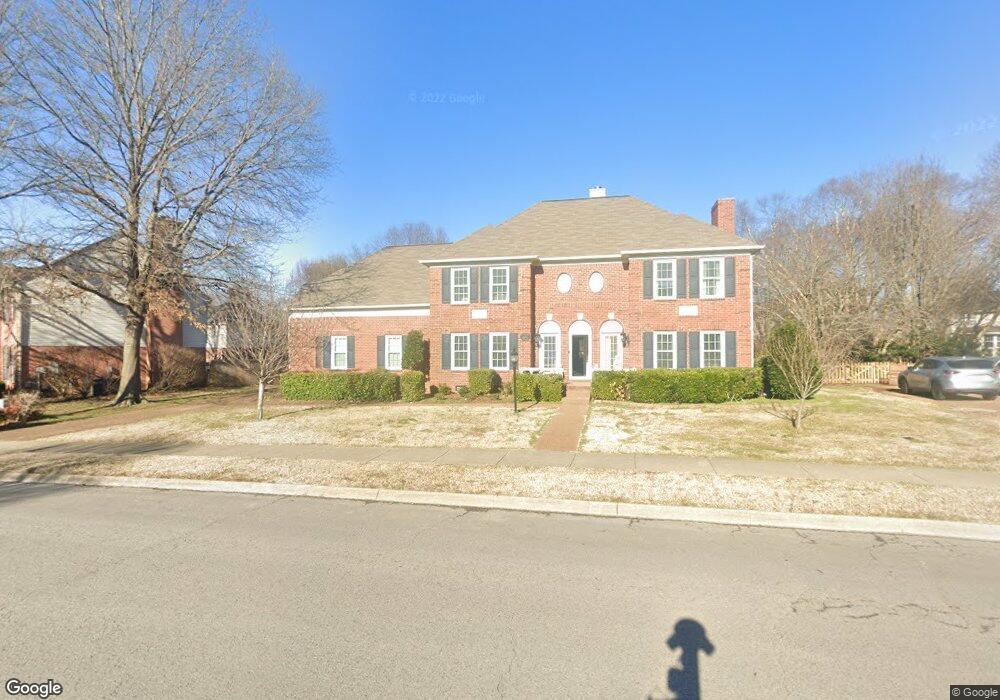
304 Founders Pointe Blvd Franklin, TN 37064
West Franklin NeighborhoodEstimated Value: $876,229 - $1,029,000
--
Bed
4
Baths
3,290
Sq Ft
$289/Sq Ft
Est. Value
About This Home
This home is located at 304 Founders Pointe Blvd, Franklin, TN 37064 and is currently estimated at $952,057, approximately $289 per square foot. 304 Founders Pointe Blvd is a home located in Williamson County with nearby schools including Poplar Grove K-4, Johnson Elementary School, and Poplar Grove 5-8.
Ownership History
Date
Name
Owned For
Owner Type
Purchase Details
Closed on
Jul 3, 2003
Sold by
Cendant Mobility Financial Corp
Bought by
Parker Claire C
Current Estimated Value
Purchase Details
Closed on
May 24, 2003
Sold by
Pollitt Leland Allen and Pollitt Tamulia W
Bought by
Cendant Mobility Financial Corp and Burrow Closing Management Corp
Purchase Details
Closed on
Aug 31, 1995
Bought by
Pollitt Leland Allen
Create a Home Valuation Report for This Property
The Home Valuation Report is an in-depth analysis detailing your home's value as well as a comparison with similar homes in the area
Home Values in the Area
Average Home Value in this Area
Purchase History
| Date | Buyer | Sale Price | Title Company |
|---|---|---|---|
| Parker Claire C | $273,000 | Mid South Title Agency Inc | |
| Cendant Mobility Financial Corp | $273,000 | -- | |
| Pollitt Leland Allen | $249,900 | -- |
Source: Public Records
Tax History Compared to Growth
Tax History
| Year | Tax Paid | Tax Assessment Tax Assessment Total Assessment is a certain percentage of the fair market value that is determined by local assessors to be the total taxable value of land and additions on the property. | Land | Improvement |
|---|---|---|---|---|
| 2024 | $3,672 | $129,725 | $28,750 | $100,975 |
| 2023 | $3,530 | $129,725 | $28,750 | $100,975 |
| 2022 | $3,530 | $129,725 | $28,750 | $100,975 |
| 2021 | $3,530 | $129,725 | $28,750 | $100,975 |
| 2020 | $3,270 | $101,375 | $22,500 | $78,875 |
| 2019 | $3,270 | $101,375 | $22,500 | $78,875 |
| 2018 | $3,199 | $101,375 | $22,500 | $78,875 |
| 2017 | $3,149 | $101,375 | $22,500 | $78,875 |
| 2016 | $3,138 | $101,375 | $22,500 | $78,875 |
| 2015 | -- | $86,925 | $15,625 | $71,300 |
| 2014 | -- | $86,925 | $15,625 | $71,300 |
Source: Public Records
Map
Nearby Homes
- 305 Abram Ct
- 310 Devonshire Dr
- 714 Founders Pointe Blvd
- 527 Antebellum Ct
- 523 Antebellum Ct
- Azalea Plan at Reese
- Jordan Plan at Reese
- 215 Wrennewood Ln
- 5029 Owenruth Dr
- 226 Wrennewood Ln
- 1632 Cooper Creek Ln
- 3126 Bush Dr
- 301 Connelly Ct
- 5037 Owenruth Dr
- 4068 Penfield Dr
- 4064 Penfield Dr
- 4072 Penfield Dr
- 4060 Penfield Dr
- 5041 Owenruth Dr
- 3042 Blossom Trail Ln
- 306 Founders Pointe Blvd
- 302 Founders Pointe Blvd
- 505 Sharpe Dr
- 507 Sharpe Dr
- 503 Sharpe Dr
- 303 Founders Pointe Blvd
- 509 Sharpe Dr
- 300 Founders Pointe Blvd
- 305 Founders Pointe Blvd
- 112 Lancelot Ln
- 501 Sharpe Dr
- 110 Lancelot Ln
- 603 Rutherford Ln
- 401 Fontaine Dr
- 400 Fontaine Dr
- 508 Sharpe Dr
- 108 Lancelot Ln
- 403 Founders Pointe Blvd
- 200 Lancelot Ln
- 117 Lancelot Ln