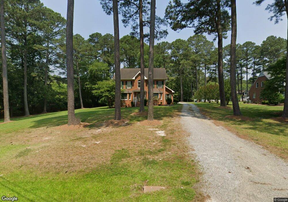
304 Homestead Rd Franklin, VA 23851
Estimated Value: $369,000 - $415,000
3
Beds
3
Baths
2,536
Sq Ft
$151/Sq Ft
Est. Value
About This Home
This home is located at 304 Homestead Rd, Franklin, VA 23851 and is currently estimated at $382,859, approximately $150 per square foot. 304 Homestead Rd is a home located in Franklin City with nearby schools including S.P. Morton Elementary School, Joseph P. King Jr. Middle School, and Franklin High School.
Ownership History
Date
Name
Owned For
Owner Type
Purchase Details
Closed on
Jan 8, 2007
Sold by
Equity Trustees Llc Sub Tr
Bought by
Hatch Antwan
Current Estimated Value
Home Financials for this Owner
Home Financials are based on the most recent Mortgage that was taken out on this home.
Original Mortgage
$210,000
Outstanding Balance
$125,705
Interest Rate
6.24%
Mortgage Type
New Conventional
Estimated Equity
$257,154
Create a Home Valuation Report for This Property
The Home Valuation Report is an in-depth analysis detailing your home's value as well as a comparison with similar homes in the area
Home Values in the Area
Average Home Value in this Area
Purchase History
| Date | Buyer | Sale Price | Title Company |
|---|---|---|---|
| Hatch Antwan | $135,915 | -- |
Source: Public Records
Mortgage History
| Date | Status | Borrower | Loan Amount |
|---|---|---|---|
| Open | Hatch Antwan | $210,000 |
Source: Public Records
Tax History Compared to Growth
Tax History
| Year | Tax Paid | Tax Assessment Tax Assessment Total Assessment is a certain percentage of the fair market value that is determined by local assessors to be the total taxable value of land and additions on the property. | Land | Improvement |
|---|---|---|---|---|
| 2024 | $3,461 | $336,000 | $60,600 | $275,400 |
| 2023 | $2,700 | $262,100 | $54,200 | $207,900 |
| 2022 | $2,700 | $262,100 | $54,200 | $207,900 |
| 2021 | $2,347 | $227,900 | $49,300 | $178,600 |
| 2020 | $2,274 | $227,900 | $49,300 | $178,600 |
| 2019 | $2,274 | $229,700 | $54,200 | $175,500 |
| 2018 | $2,274 | $229,700 | $54,200 | $175,500 |
| 2017 | $2,149 | $217,100 | $49,200 | $167,900 |
| 2016 | $2,149 | $217,100 | $49,200 | $167,900 |
| 2015 | -- | $0 | $0 | $0 |
| 2014 | -- | $0 | $0 | $0 |
| 2013 | -- | $0 | $0 | $0 |
Source: Public Records
Map
Nearby Homes
- 105 Homestead Rd
- 904 N High St
- 317 Carrie Dr
- 307 Beaman St
- 105 Barrister Ln
- 711 Orchard St
- 100 Sunset Dr
- 256 Summit Path
- 241 Summit Path
- 614 N High St
- 214 Summit Path
- 210 Summit Path
- 208 Summit Path
- 206 Summit Path
- 204 Summit Path
- 200 Summit Path
- 221 Summit Path
- 202 Summit Path
- 212 Summit Path
- 222 Summit Path
- 300 Homestead Rd
- 100 Forest Pine Rd
- 301 Homestead Rd
- 400 Lytton St
- 219 Homestead Rd
- 208 Homestead Rd
- 132 Wynnwood Dr
- 309 Homestead Rd
- 201 Forest Pine Rd
- 201 Forest Pine Rd
- 121 Wynnwood Dr
- 101 Forest Pine Rd
- 204 Homestead Rd
- 128 Wynnwood Dr
- 308 Edwards St
- 117 Wynnwood Dr
- 308 Beale Ct
- 200 Homestead Rd
- 828 Clay St
- 826 Clay St