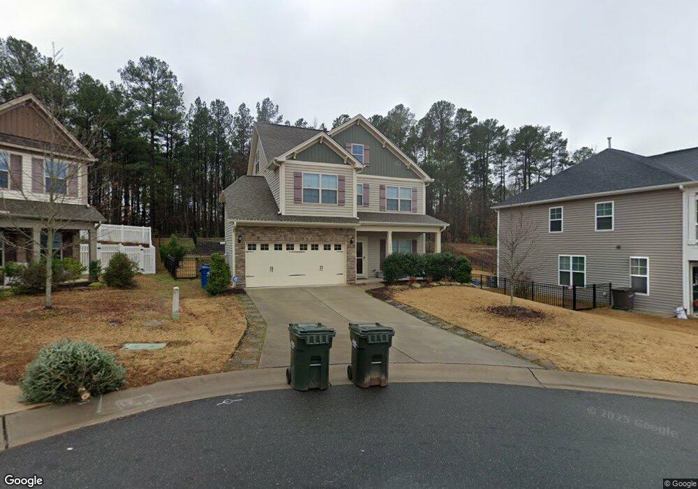
304 Maple Walk St Durham, NC 27703
South Durham NeighborhoodEstimated Value: $446,816 - $498,000
3
Beds
3
Baths
2,149
Sq Ft
$223/Sq Ft
Est. Value
About This Home
This home is located at 304 Maple Walk St, Durham, NC 27703 and is currently estimated at $478,454, approximately $222 per square foot. 304 Maple Walk St is a home located in Durham County with nearby schools including R.N. Harris Elementary School, James E. Shepard Middle School, and Hillside High School.
Ownership History
Date
Name
Owned For
Owner Type
Purchase Details
Closed on
Jun 15, 2017
Sold by
Mungo Homes Of North Carolina Inc
Bought by
Johnson Ii Lewis Nathaniel
Current Estimated Value
Home Financials for this Owner
Home Financials are based on the most recent Mortgage that was taken out on this home.
Original Mortgage
$264,898
Outstanding Balance
$220,340
Interest Rate
4.02%
Mortgage Type
New Conventional
Estimated Equity
$258,114
Create a Home Valuation Report for This Property
The Home Valuation Report is an in-depth analysis detailing your home's value as well as a comparison with similar homes in the area
Home Values in the Area
Average Home Value in this Area
Purchase History
| Date | Buyer | Sale Price | Title Company |
|---|---|---|---|
| Johnson Ii Lewis Nathaniel | $279,000 | None Available |
Source: Public Records
Mortgage History
| Date | Status | Borrower | Loan Amount |
|---|---|---|---|
| Open | Johnson Ii Lewis Nathaniel | $264,898 |
Source: Public Records
Tax History
| Year | Tax Paid | Tax Assessment Tax Assessment Total Assessment is a certain percentage of the fair market value that is determined by local assessors to be the total taxable value of land and additions on the property. | Land | Improvement |
|---|---|---|---|---|
| 2025 | $4,525 | $456,445 | $87,750 | $368,695 |
| 2024 | $3,675 | $263,424 | $58,350 | $205,074 |
| 2023 | $3,451 | $263,424 | $58,350 | $205,074 |
| 2022 | $3,372 | $263,424 | $58,350 | $205,074 |
| 2021 | $3,356 | $263,424 | $58,350 | $205,074 |
| 2020 | $3,277 | $263,424 | $58,350 | $205,074 |
| 2019 | $3,277 | $263,424 | $58,350 | $205,074 |
| 2018 | $3,033 | $203,131 | $20,422 | $182,709 |
| 2017 | $2,334 | $173,309 | $20,422 | $152,887 |
| 2016 | $266 | $40,845 | $40,845 | $0 |
Source: Public Records
Map
Nearby Homes
- 229 Zante Currant Rd
- 2605 Magnolia Tree Ln
- 204 Garden Walk Dr
- 52 Holly Berry Ln
- 2638 S Alston Ave
- 3004 Cypress Lagoon Ct
- 1912 So Hi Dr
- 3305 Delmar Dr
- 3303 Delmar Dr
- 1905 Edgerton Dr
- 17 Eddy Trail
- 2458 S Alston Ave
- 2010 Eastwood Dr
- 1206 Ellis Rd
- 1202 Ellis Rd
- 1226 Helms St
- 1135 Longitude Dr
- 1412 Scholar Dr
- 1224 Helms St
- 1222 Helms St
- 306 Maple Walk St
- 216 Maple Walk St
- 305 Maple Walk St
- 214 Maple Walk St
- 102 White Burley Ct
- 210 Maple Walk St
- 217 Maple Walk St
- 104 White Burley Ct
- 215 Maple Walk St
- 208 Maple Walk St
- 211 Maple Walk St
- 1703 Ed Cook Rd
- 1707 Ed Cook Rd
- 209 Maple Walk St
- 107 White Burley Ct
- 1617 Ed Cook Rd
- 204 Maple Walk St
- 207 Maple Walk St
- 1710 Ed Cook Rd
- 109 White Burley Ct
Your Personal Tour Guide
Ask me questions while you tour the home.