Estimated Value: $332,000 - $345,000
--
Bed
--
Bath
1,308
Sq Ft
$260/Sq Ft
Est. Value
About This Home
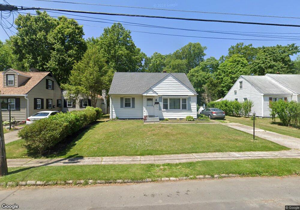
This home is located at 304 Wynnewood Rd, Ewing, NJ 08628 and is currently estimated at $339,768, approximately $259 per square foot. 304 Wynnewood Rd is a home located in Mercer County with nearby schools including Ewing High School, The Village Charter School, and Christina Seix Academy.
Ownership History
Date
Name
Owned For
Owner Type
Purchase Details
Closed on
Apr 29, 2002
Current Estimated Value
Purchase Details
Closed on
Nov 5, 1993
Sold by
Bryan Ralph O
Bought by
Bryan Kenneth O
Home Financials for this Owner
Home Financials are based on the most recent Mortgage that was taken out on this home.
Original Mortgage
$60,000
Interest Rate
6.83%
Create a Home Valuation Report for This Property
The Home Valuation Report is an in-depth analysis detailing your home's value as well as a comparison with similar homes in the area
Home Values in the Area
Average Home Value in this Area
Purchase History
| Date | Buyer | Sale Price | Title Company |
|---|---|---|---|
| -- | $118,000 | -- | |
| Bryan Kenneth O | $90,000 | -- |
Source: Public Records
Mortgage History
| Date | Status | Borrower | Loan Amount |
|---|---|---|---|
| Previous Owner | Bryan Kenneth O | $60,000 |
Source: Public Records
Tax History Compared to Growth
Tax History
| Year | Tax Paid | Tax Assessment Tax Assessment Total Assessment is a certain percentage of the fair market value that is determined by local assessors to be the total taxable value of land and additions on the property. | Land | Improvement |
|---|---|---|---|---|
| 2025 | $6,434 | $163,600 | $56,100 | $107,500 |
| 2024 | $6,048 | $163,600 | $56,100 | $107,500 |
| 2023 | $6,048 | $163,600 | $56,100 | $107,500 |
| 2022 | $5,885 | $163,600 | $56,100 | $107,500 |
| 2021 | $5,741 | $163,600 | $56,100 | $107,500 |
| 2020 | $5,659 | $163,600 | $56,100 | $107,500 |
| 2019 | $5,512 | $163,600 | $56,100 | $107,500 |
| 2018 | $4,939 | $93,500 | $48,000 | $45,500 |
| 2017 | $5,054 | $93,500 | $48,000 | $45,500 |
| 2016 | $4,985 | $93,500 | $48,000 | $45,500 |
| 2015 | $4,919 | $93,500 | $48,000 | $45,500 |
| 2014 | $4,906 | $93,500 | $48,000 | $45,500 |
Source: Public Records
Map
Nearby Homes
- 325 Silvia St
- 288 Clamer Rd
- 1200 Silvia St
- 262 Clamer Rd
- 4 Downing Rd
- 860 Lower Ferry Rd Unit 1K
- 21 Dixmont Ave
- 136 Palmer Ln
- 528 Mrtn King Jr
- 512 Mrtn King Jr
- 94 Hinckle Ave
- 21 Decou Ave
- 15 Decou Ave
- 6 Michelle Ct
- 30 Chelmsford Ct
- 43 W Upper Ferry Rd
- 7 Boone Ave
- 7 Hinckle Ave
- 115 Stratford Ave
- 32 Farrell Ave
- 302 Wynnewood Rd
- 306 Wynnewood Rd
- 300 Wynnewood Rd
- 308 Wynnewood Rd
- 481 Silvia St
- 483 Silvia St Unit H483
- 407 Silvia St
- 487 Silvia St
- 409 Silvia St Unit BLDG E
- 409 Silvia St
- 485 Silvia St
- 405 Silvia St
- 489 Silvia St
- 411 Silvia St
- 298 Wynnewood Rd
- 491 Silvia St
- 403 Silvia St
- 413 Silvia St
- 1 Plaza Ct
- 401 Silvia St