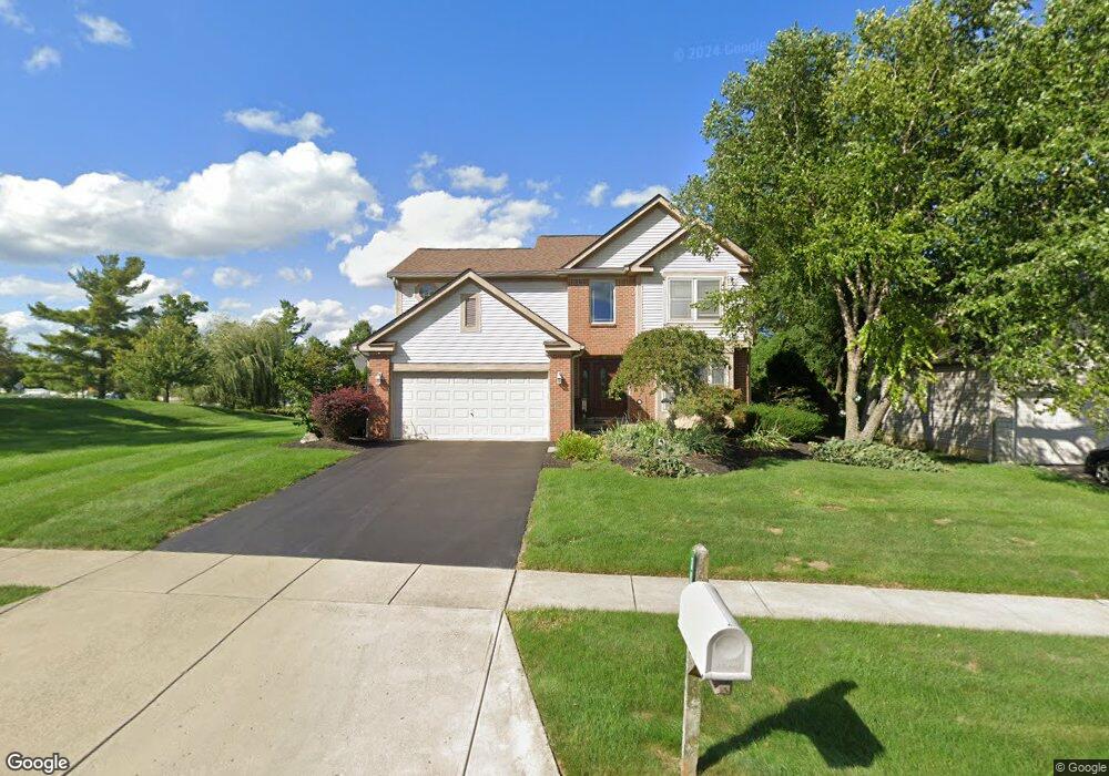
3040 Libertydale Dr Powell, OH 43065
Liberty Township NeighborhoodEstimated Value: $486,000 - $574,000
4
Beds
3
Baths
2,262
Sq Ft
$234/Sq Ft
Est. Value
About This Home
This home is located at 3040 Libertydale Dr, Powell, OH 43065 and is currently estimated at $530,134, approximately $234 per square foot. 3040 Libertydale Dr is a home located in Delaware County with nearby schools including Tyler Run Elementary School, Olentangy Liberty Middle School, and Olentangy Liberty High School.
Ownership History
Date
Name
Owned For
Owner Type
Purchase Details
Closed on
Jun 29, 2001
Sold by
Rockford Homes Inc
Bought by
Domansky Michael J and Domansky Pamela A
Current Estimated Value
Home Financials for this Owner
Home Financials are based on the most recent Mortgage that was taken out on this home.
Original Mortgage
$210,900
Outstanding Balance
$81,512
Interest Rate
7.18%
Mortgage Type
New Conventional
Estimated Equity
$448,622
Create a Home Valuation Report for This Property
The Home Valuation Report is an in-depth analysis detailing your home's value as well as a comparison with similar homes in the area
Home Values in the Area
Average Home Value in this Area
Purchase History
| Date | Buyer | Sale Price | Title Company |
|---|---|---|---|
| Domansky Michael J | $222,000 | -- |
Source: Public Records
Mortgage History
| Date | Status | Borrower | Loan Amount |
|---|---|---|---|
| Open | Domansky Michael J | $210,900 |
Source: Public Records
Tax History Compared to Growth
Tax History
| Year | Tax Paid | Tax Assessment Tax Assessment Total Assessment is a certain percentage of the fair market value that is determined by local assessors to be the total taxable value of land and additions on the property. | Land | Improvement |
|---|---|---|---|---|
| 2024 | $7,319 | $136,230 | $31,680 | $104,550 |
| 2023 | $7,347 | $136,230 | $31,680 | $104,550 |
| 2022 | $7,511 | $110,460 | $21,000 | $89,460 |
| 2021 | $7,556 | $110,460 | $21,000 | $89,460 |
| 2020 | $7,592 | $110,460 | $21,000 | $89,460 |
| 2019 | $6,211 | $93,730 | $21,000 | $72,730 |
| 2018 | $6,240 | $93,730 | $21,000 | $72,730 |
| 2017 | $5,662 | $85,200 | $15,300 | $69,900 |
| 2016 | $5,877 | $85,200 | $15,300 | $69,900 |
| 2015 | $5,316 | $85,200 | $15,300 | $69,900 |
| 2014 | $5,389 | $85,200 | $15,300 | $69,900 |
| 2013 | $5,237 | $81,140 | $15,300 | $65,840 |
Source: Public Records
Map
Nearby Homes
- 2961 Lexington Dr
- 8803 Yates Point Ct
- 8796 Yates Point Ct
- 8741 Jamey Ct
- 55 Timber Oak Ct
- 2013 Summit Row Blvd
- 2168 Summit Row Blvd
- 91 Tiller Dr
- 274 Stamford Dr
- 1949 Hamrock Dr
- 261 Andover Dr
- 2228 Gnarled Pine Dr
- 10586 Churchill Dr
- 8292 Breckenridge Way
- 2672 Sawmill Reserve Dr Unit 2672
- 8345 Smoky Row Rd Unit 8345
- 7898 Sarahurst Dr
- 524 Commons Dr Unit 524
- 1937 Liberty St
- 2020 Liberty St
- 3030 Libertydale Dr
- 10599 Liberty Rd S
- 3000 Lexington Dr
- 3033 Jamestown Dr
- 3015 Lexington Dr
- 2988 Lexington Dr
- 3029 Jamestown Dr
- 2999 Lexington Dr
- 2978 Lexington Dr
- 3030 Jamestown Dr
- 10551 Liberty Rd S
- 2981 Lexington Dr
- 3023 Jamestown Dr
- 3020 Jamestown Dr
- 2966 Lexington Dr
- 3017 Jamestown Dr
- 2970 Plymouth Ct
- 3010 Jamestown Dr
- 2979 Plymouth Ct
- 2945 Lexington Dr