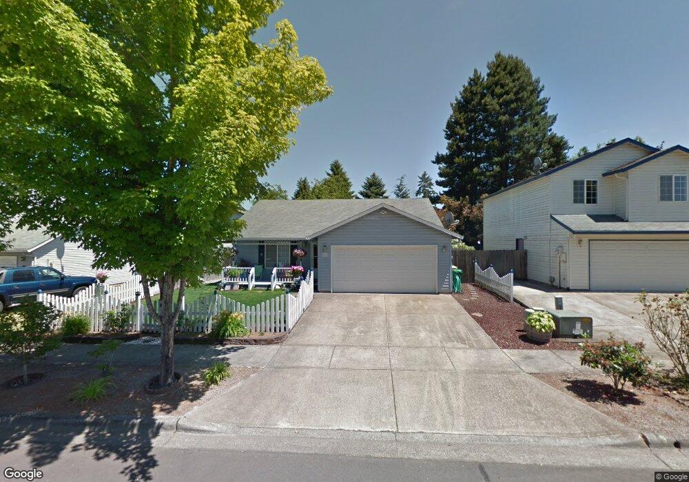
3047 Ash St Forest Grove, OR 97116
Estimated Value: $413,000 - $501,000
3
Beds
2
Baths
1,200
Sq Ft
$380/Sq Ft
Est. Value
About This Home
This home is located at 3047 Ash St, Forest Grove, OR 97116 and is currently estimated at $455,960, approximately $379 per square foot. 3047 Ash St is a home located in Washington County with nearby schools including Harvey Clarke Elementary School, Tom McCall Upper Elementary School, and Neil Armstrong Middle School.
Ownership History
Date
Name
Owned For
Owner Type
Purchase Details
Closed on
Aug 25, 2008
Sold by
Burke Patrick M and Burke Brenda J
Bought by
Smath Kay L
Current Estimated Value
Home Financials for this Owner
Home Financials are based on the most recent Mortgage that was taken out on this home.
Original Mortgage
$208,210
Outstanding Balance
$135,678
Interest Rate
6.27%
Mortgage Type
FHA
Estimated Equity
$320,282
Purchase Details
Closed on
Oct 30, 1996
Sold by
Quail Construction Inc
Bought by
Burke Patrick M and Burke Brenda J
Home Financials for this Owner
Home Financials are based on the most recent Mortgage that was taken out on this home.
Original Mortgage
$118,191
Interest Rate
8.11%
Mortgage Type
FHA
Create a Home Valuation Report for This Property
The Home Valuation Report is an in-depth analysis detailing your home's value as well as a comparison with similar homes in the area
Home Values in the Area
Average Home Value in this Area
Purchase History
| Date | Buyer | Sale Price | Title Company |
|---|---|---|---|
| Smath Kay L | $212,000 | Fidelity Natl Title Co Of Or | |
| Burke Patrick M | $118,899 | First American Title Ins Co |
Source: Public Records
Mortgage History
| Date | Status | Borrower | Loan Amount |
|---|---|---|---|
| Open | Smath Kay L | $208,210 | |
| Previous Owner | Burke Patrick M | $118,191 |
Source: Public Records
Tax History Compared to Growth
Tax History
| Year | Tax Paid | Tax Assessment Tax Assessment Total Assessment is a certain percentage of the fair market value that is determined by local assessors to be the total taxable value of land and additions on the property. | Land | Improvement |
|---|---|---|---|---|
| 2026 | $3,950 | $221,840 | -- | -- |
| 2025 | $3,950 | $215,380 | -- | -- |
| 2024 | $3,811 | $209,110 | -- | -- |
| 2023 | $3,811 | $203,020 | $0 | $0 |
| 2022 | $3,332 | $203,020 | $0 | $0 |
| 2021 | $3,289 | $191,370 | $0 | $0 |
| 2020 | $3,271 | $185,800 | $0 | $0 |
| 2019 | $3,199 | $180,390 | $0 | $0 |
| 2018 | $3,100 | $175,140 | $0 | $0 |
| 2017 | $3,005 | $170,040 | $0 | $0 |
| 2016 | $2,920 | $165,090 | $0 | $0 |
| 2015 | $2,808 | $160,290 | $0 | $0 |
| 2014 | $2,794 | $155,630 | $0 | $0 |
Source: Public Records
Map
Nearby Homes
- 2106 Charlie Ct
- 3300 N Main St Unit 110
- 2251 27th Ave
- 2081 Silverstone Dr
- 3594 Ash St Unit Lot 25
- 3613 Chestnut St Unit Lot 48
- 2043 35th Ave
- 2091 35th Ave
- 2035 35th Ave
- 904 Rosebud Ct
- Alder Plan at Parkview Terrace - Single-Family Homes
- Mattingly Plan at Parkview Terrace - Single-Family Homes
- Arleta Plan at Parkview Terrace - Paired Villas
- Moreland Plan at Parkview Terrace - Paired Villas
- Eason Plan at Parkview Terrace - Single-Family Homes
- Marivue Plan at Parkview Terrace - Paired Villas
- Albin Plan at Parkview Terrace - Single-Family Homes
- 916 Rosebud Ct
- Caden Plan at Parkview Terrace - Single-Family Homes
- 803 Misty Ln