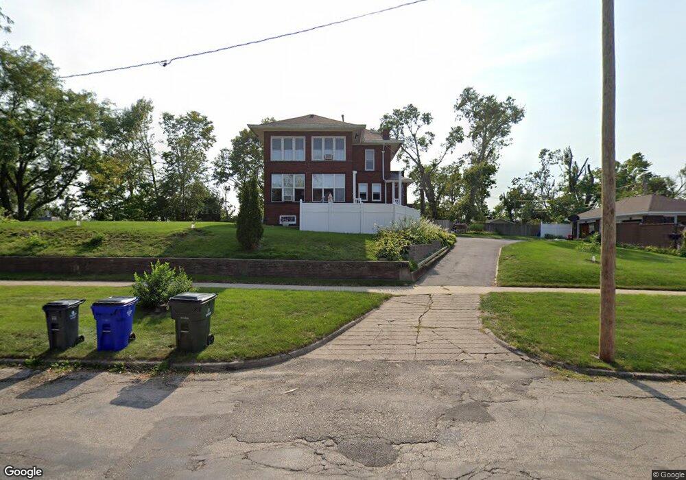
305 19th St NE Cedar Rapids, IA 52402
Mound View NeighborhoodEstimated Value: $244,000 - $532,754
6
Beds
5
Baths
4,572
Sq Ft
$85/Sq Ft
Est. Value
About This Home
This home is located at 305 19th St NE, Cedar Rapids, IA 52402 and is currently estimated at $388,377, approximately $84 per square foot. 305 19th St NE is a home located in Linn County with nearby schools including Arthur Elementary School, Franklin Middle School, and George Washington High School.
Ownership History
Date
Name
Owned For
Owner Type
Purchase Details
Closed on
Jul 25, 2008
Sold by
Pittam Gregory D
Bought by
Rippe Seth A and Rippe Catherine M
Current Estimated Value
Home Financials for this Owner
Home Financials are based on the most recent Mortgage that was taken out on this home.
Original Mortgage
$285,000
Outstanding Balance
$186,546
Interest Rate
6.36%
Mortgage Type
Purchase Money Mortgage
Estimated Equity
$201,831
Purchase Details
Closed on
Aug 12, 2005
Sold by
Bradley Marcia J and Mccullough Roger L
Bought by
Pittam Gregory D
Home Financials for this Owner
Home Financials are based on the most recent Mortgage that was taken out on this home.
Original Mortgage
$159,600
Interest Rate
5.69%
Mortgage Type
Fannie Mae Freddie Mac
Create a Home Valuation Report for This Property
The Home Valuation Report is an in-depth analysis detailing your home's value as well as a comparison with similar homes in the area
Home Values in the Area
Average Home Value in this Area
Purchase History
| Date | Buyer | Sale Price | Title Company |
|---|---|---|---|
| Rippe Seth A | $299,500 | None Available | |
| Pittam Gregory D | $199,000 | -- |
Source: Public Records
Mortgage History
| Date | Status | Borrower | Loan Amount |
|---|---|---|---|
| Open | Rippe Seth A | $285,000 | |
| Previous Owner | Pittam Gregory D | $159,600 |
Source: Public Records
Tax History Compared to Growth
Tax History
| Year | Tax Paid | Tax Assessment Tax Assessment Total Assessment is a certain percentage of the fair market value that is determined by local assessors to be the total taxable value of land and additions on the property. | Land | Improvement |
|---|---|---|---|---|
| 2025 | $5,342 | $353,100 | $103,300 | $249,800 |
| 2024 | $6,022 | $330,000 | $95,300 | $234,700 |
| 2023 | $6,022 | $312,300 | $79,400 | $232,900 |
| 2022 | $5,766 | $294,400 | $79,400 | $215,000 |
| 2021 | $5,824 | $287,300 | $79,400 | $207,900 |
| 2020 | $5,824 | $272,600 | $79,400 | $193,200 |
| 2019 | $5,180 | $248,800 | $79,400 | $169,400 |
| 2018 | $4,894 | $248,800 | $79,400 | $169,400 |
| 2017 | $4,108 | $197,200 | $79,400 | $117,800 |
| 2016 | $4,633 | $218,000 | $79,400 | $138,600 |
| 2015 | $4,779 | $224,577 | $79,443 | $145,134 |
| 2014 | $4,594 | $224,577 | $79,443 | $145,134 |
| 2013 | $4,490 | $224,577 | $79,443 | $145,134 |
Source: Public Records
Map
Nearby Homes
- 1746 B Ave NE
- 1857 E Ave NE
- 1748 A Ave NE
- 1815 E Ave NE
- 517 18th St NE
- 1953 1st Ave E Unit 301
- 1953 1st Ave SE Unit 301
- 1953 1st Ave SE Unit 503
- 1703 A Ave NE
- 116 17th St NE
- 8821 Zeppelin Ave NE
- 122 20th St NE
- 225 Crescent St SE
- 1608 B Ave NE
- 1630 1st Ave NE
- 205 21st St NE
- 418 21st St NE
- 306 21st St NE
- 514 16th St NE
- 1551 C Ave NE