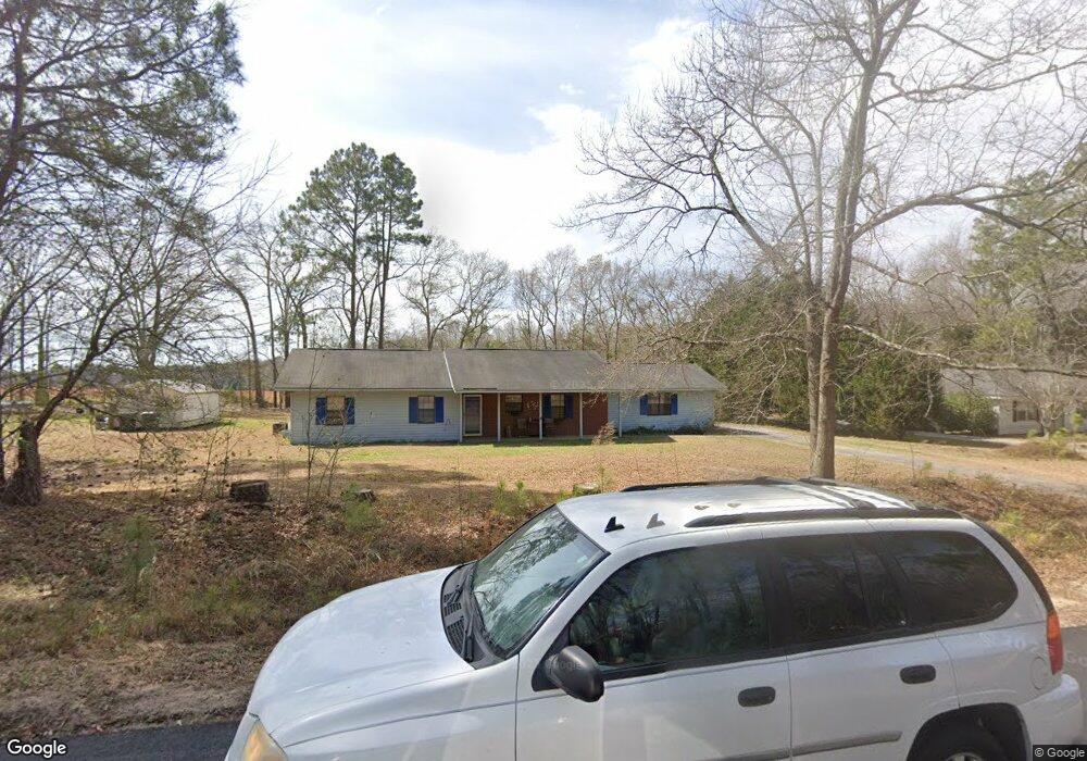
305 Longwood Dr Statesboro, GA 30461
Estimated Value: $221,000 - $231,000
3
Beds
2
Baths
1,272
Sq Ft
$179/Sq Ft
Est. Value
About This Home
This home is located at 305 Longwood Dr, Statesboro, GA 30461 and is currently estimated at $227,062, approximately $178 per square foot. 305 Longwood Dr is a home located in Bulloch County with nearby schools including Sallie Zetterower Elementary School, Statesboro High School, and Langston Chapel Middle School.
Ownership History
Date
Name
Owned For
Owner Type
Purchase Details
Closed on
Aug 13, 2025
Sold by
Snyder Catherine Carroll
Bought by
Snyder Catherine Carroll and Snyder Jeffrey E
Current Estimated Value
Purchase Details
Closed on
May 9, 2017
Sold by
Battey Viola G
Bought by
Snyder Jeffrey E and Snyder Catherine E
Purchase Details
Closed on
Dec 31, 2009
Sold by
Battey Agnes Mildred
Bought by
Battey Viola G
Purchase Details
Closed on
Oct 16, 2009
Sold by
Loadholt Carolyn Amelia
Bought by
Battey Agnes Mildred
Purchase Details
Closed on
Oct 1, 1980
Bought by
Loadholt Carolyn
Create a Home Valuation Report for This Property
The Home Valuation Report is an in-depth analysis detailing your home's value as well as a comparison with similar homes in the area
Home Values in the Area
Average Home Value in this Area
Purchase History
| Date | Buyer | Sale Price | Title Company |
|---|---|---|---|
| Snyder Catherine Carroll | -- | -- | |
| Snyder Jeffrey E | $80,000 | -- | |
| Battey Viola G | -- | -- | |
| Battey Agnes Mildred | -- | -- | |
| Loadholt Carolyn | -- | -- |
Source: Public Records
Tax History Compared to Growth
Tax History
| Year | Tax Paid | Tax Assessment Tax Assessment Total Assessment is a certain percentage of the fair market value that is determined by local assessors to be the total taxable value of land and additions on the property. | Land | Improvement |
|---|---|---|---|---|
| 2024 | $1,450 | $67,960 | $14,000 | $53,960 |
| 2023 | $182 | $60,880 | $12,000 | $48,880 |
| 2022 | $1,135 | $53,910 | $12,000 | $41,910 |
| 2021 | $930 | $43,473 | $9,520 | $33,953 |
| 2020 | $845 | $39,456 | $9,520 | $29,936 |
| 2019 | $852 | $39,598 | $9,520 | $30,078 |
| 2018 | $707 | $36,971 | $9,520 | $27,451 |
| 2017 | $847 | $35,542 | $9,520 | $26,022 |
| 2016 | $849 | $34,786 | $9,520 | $25,266 |
| 2015 | $825 | $33,701 | $9,520 | $24,181 |
| 2014 | $763 | $33,701 | $9,520 | $24,181 |
Source: Public Records
Map
Nearby Homes
- 314 Longwood Dr
- 106 Lincoln St
- 2.055 ACRES S and S Railroad Bed Rd
- 1139 Bartlett Dr
- 1143 Bartlett Dr
- 1136 Bartlett Dr
- 115 Sandy Way
- 117 Circle Dr
- 23606 Us Highway 80 E
- 1008 Cawana Rd
- 0 Cawana Rd Unit 10619496
- 207 N Jackson Rd
- 239 Circle Dr
- Cali Plan at Holly Oaks
- Kerry Plan at Holly Oaks
- Belhaven Plan at Holly Oaks
- Freeport Plan at Holly Oaks
- Manning Plan at Holly Oaks
- Robie Plan at Holly Oaks
- 402 Jacob Ct
- 307 Longwood Dr
- 303 Longwood Dr
- 306 Longwood Dr
- 309 Longwood Dr
- 301 Longwood Dr
- 113 Slough Creek Rd Unit 12
- 113 Slough Creek Rd
- 308 Longwood Dr
- 108 Slough Creek Rd
- 311 Longwood Dr
- 111 Slough Creek Rd Unit 11
- 111 Slough Creek Rd
- 106 Slough Creek Rd
- 310 Longwood Dr
- 313 Longwood Dr
- 109 Slough Creek Rd
- 107 Slough Creek Rd
- 3 Meadow Dr
- 315 Longwood Dr
- 5 Meadow Dr