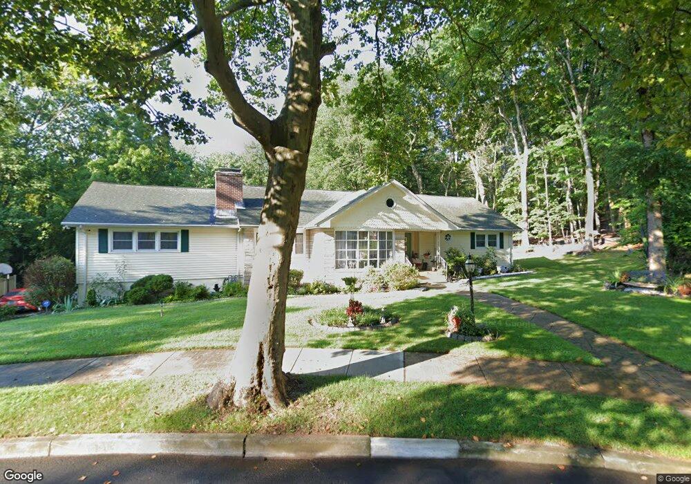
305 Stevenson Rd New Haven, CT 06515
Westville NeighborhoodEstimated Value: $500,000 - $532,000
3
Beds
2
Baths
2,388
Sq Ft
$218/Sq Ft
Est. Value
About This Home
This home is located at 305 Stevenson Rd, New Haven, CT 06515 and is currently estimated at $521,322, approximately $218 per square foot. 305 Stevenson Rd is a home located in New Haven County with nearby schools including Davis Academy for Arts & Design Innovation, Elm City Montessori School, and Hopkins School.
Ownership History
Date
Name
Owned For
Owner Type
Purchase Details
Closed on
May 15, 1997
Sold by
Orr Maria P
Bought by
Spence Keith M and Spence Craddock-Spence M
Current Estimated Value
Create a Home Valuation Report for This Property
The Home Valuation Report is an in-depth analysis detailing your home's value as well as a comparison with similar homes in the area
Home Values in the Area
Average Home Value in this Area
Purchase History
| Date | Buyer | Sale Price | Title Company |
|---|---|---|---|
| Spence Keith M | $134,000 | -- |
Source: Public Records
Mortgage History
| Date | Status | Borrower | Loan Amount |
|---|---|---|---|
| Open | Spence Keith M | $100,000 | |
| Closed | Spence Keith M | $10,000 | |
| Closed | Spence Keith M | $210,000 | |
| Closed | Spence Keith M | $175,000 |
Source: Public Records
Tax History
| Year | Tax Paid | Tax Assessment Tax Assessment Total Assessment is a certain percentage of the fair market value that is determined by local assessors to be the total taxable value of land and additions on the property. | Land | Improvement |
|---|---|---|---|---|
| 2025 | $11,087 | $281,400 | $64,750 | $216,650 |
| 2024 | $10,834 | $281,400 | $64,750 | $216,650 |
| 2023 | $10,468 | $281,400 | $64,750 | $216,650 |
| 2022 | $11,186 | $281,400 | $64,750 | $216,650 |
| 2021 | $9,359 | $213,290 | $42,070 | $171,220 |
| 2020 | $9,359 | $213,290 | $42,070 | $171,220 |
| 2019 | $9,167 | $213,290 | $42,070 | $171,220 |
| 2018 | $9,167 | $213,290 | $42,070 | $171,220 |
| 2017 | $8,250 | $213,290 | $42,070 | $171,220 |
| 2016 | $8,757 | $210,770 | $43,680 | $167,090 |
| 2015 | $8,757 | $210,770 | $43,680 | $167,090 |
| 2014 | $8,757 | $210,770 | $43,680 | $167,090 |
Source: Public Records
Map
Nearby Homes
- 690 Forest Rd Unit 702
- 690 Forest Rd Unit 761
- 690 Forest Rd Unit 501
- 690 Forest Rd Unit 651
- 56 Roger Rd
- 224 Ray Rd
- 119 Westwood Rd
- 50 Morris Ave
- 21 Richmond Ave
- 125 Lowin Ave
- 51 Fountain Terrace
- 55 Marvel Rd
- 252 Alden Ave
- 420 Central Ave
- 50 Maltby Ave
- 34 Maltby Ave
- 110 Fenwick St
- 846 Beechwood Rd
- 143 Fountain St Unit A11
- 127 Rangely St
- 295 Stevenson Rd
- 315 Stevenson Rd
- 294 Stevenson Rd
- 285 Stevenson Rd
- 325 Stevenson Rd
- 46 Spencer Place
- 284 Stevenson Rd
- 345 Stevenson Rd
- 36 Spencer Place
- 271 Stevenson Rd
- 270 Stevenson Rd
- 45 Spencer Place
- 355 Stevenson Rd
- 26 Spencer Place
- 35 Spencer Place
- 262 Stevenson Rd
- 257 Stevenson Rd
- 365 Stevenson Rd
- 360 Stevenson Rd
- 16 Spencer Place
Your Personal Tour Guide
Ask me questions while you tour the home.