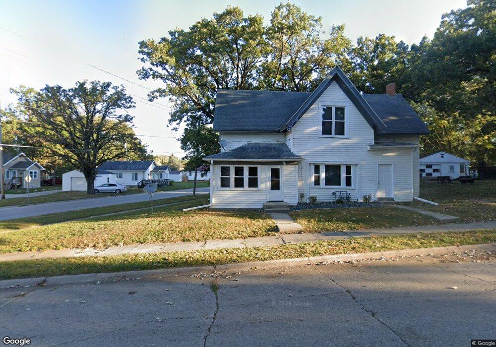
306 10th St NE Unit 308 Mason City, IA 50401
Estimated Value: $56,000 - $93,294
4
Beds
2
Baths
1,523
Sq Ft
$48/Sq Ft
Est. Value
About This Home
This home is located at 306 10th St NE Unit 308, Mason City, IA 50401 and is currently estimated at $73,324, approximately $48 per square foot. 306 10th St NE Unit 308 is a home located in Cerro Gordo County with nearby schools including Mason City High School, Mason City Seventh Day Adventi, and North Iowa Christian School.
Ownership History
Date
Name
Owned For
Owner Type
Purchase Details
Closed on
Sep 21, 2023
Sold by
Stensrude Spencer C and Stensrude Sheet
Bought by
Sky High Property Holdings Llc
Current Estimated Value
Purchase Details
Closed on
Aug 12, 2013
Sold by
Liberty Property Holdings Llc
Bought by
Stensrude Spencer C
Home Financials for this Owner
Home Financials are based on the most recent Mortgage that was taken out on this home.
Original Mortgage
$26,097
Interest Rate
4.25%
Mortgage Type
Future Advance Clause Open End Mortgage
Purchase Details
Closed on
Dec 23, 2010
Sold by
Birkey Matthew D and Birkey Christine M
Bought by
Hammond Estates Inc
Create a Home Valuation Report for This Property
The Home Valuation Report is an in-depth analysis detailing your home's value as well as a comparison with similar homes in the area
Home Values in the Area
Average Home Value in this Area
Purchase History
| Date | Buyer | Sale Price | Title Company |
|---|---|---|---|
| Sky High Property Holdings Llc | -- | None Listed On Document | |
| Stensrude Spencer C | $31,000 | None Available | |
| Hammond Estates Inc | $32,000 | None Available | |
| Birkey Matthew D | $35,000 | None Available |
Source: Public Records
Mortgage History
| Date | Status | Borrower | Loan Amount |
|---|---|---|---|
| Previous Owner | Stensrude Spencer C | $26,097 |
Source: Public Records
Tax History Compared to Growth
Tax History
| Year | Tax Paid | Tax Assessment Tax Assessment Total Assessment is a certain percentage of the fair market value that is determined by local assessors to be the total taxable value of land and additions on the property. | Land | Improvement |
|---|---|---|---|---|
| 2024 | $734 | $45,830 | $13,430 | $32,400 |
| 2023 | $734 | $45,830 | $13,430 | $32,400 |
| 2022 | $740 | $37,110 | $10,330 | $26,780 |
| 2021 | $801 | $35,980 | $10,330 | $25,650 |
| 2020 | $730 | $33,690 | $10,330 | $23,360 |
| 2019 | $700 | $0 | $0 | $0 |
| 2018 | $660 | $0 | $0 | $0 |
| 2017 | $676 | $0 | $0 | $0 |
| 2016 | $660 | $0 | $0 | $0 |
| 2015 | $660 | $0 | $0 | $0 |
| 2014 | $684 | $0 | $0 | $0 |
| 2013 | $658 | $0 | $0 | $0 |
Source: Public Records
Map
Nearby Homes
- 311 10th St NE
- 1032 N Georgia Ave
- 635 10th St NE
- 415 N Massachusetts Ave
- 128 10th St NW
- 1008 N Hampshire Ave
- 32 6th St NW
- 215 9th St NW
- 726 11th St NE
- 222 9th St NW
- 221 9th St NW
- 721 N Jefferson Ave
- 1310 N Adams Ave
- 807 10th St NE
- 221 14th St NW
- 636 2nd St NE
- 1306 N Jefferson Ave
- 682 3rd St NE
- 716 15th St NE
- 705 15th Place NE