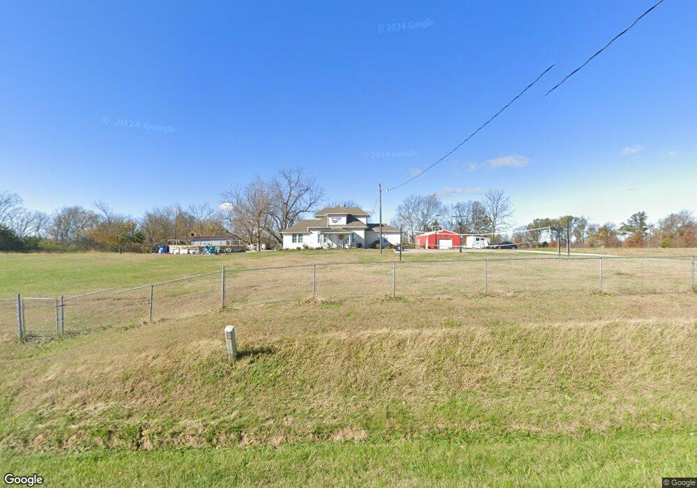
30627 172nd St Leavenworth, KS 66048
Estimated Value: $295,000 - $362,681
3
Beds
1
Bath
1,955
Sq Ft
$172/Sq Ft
Est. Value
About This Home
This home is located at 30627 172nd St, Leavenworth, KS 66048 and is currently estimated at $337,227, approximately $172 per square foot. 30627 172nd St is a home located in Leavenworth County with nearby schools including Pleasant Ridge Elementary School, Pleasant Ridge Middle School, and Pleasant Ridge High School.
Ownership History
Date
Name
Owned For
Owner Type
Purchase Details
Closed on
Nov 1, 2001
Bought by
Johnston Joseph C and Johnston Sarah B
Current Estimated Value
Home Financials for this Owner
Home Financials are based on the most recent Mortgage that was taken out on this home.
Original Mortgage
$148,000
Outstanding Balance
$57,504
Interest Rate
6.64%
Mortgage Type
New Conventional
Estimated Equity
$279,723
Create a Home Valuation Report for This Property
The Home Valuation Report is an in-depth analysis detailing your home's value as well as a comparison with similar homes in the area
Home Values in the Area
Average Home Value in this Area
Purchase History
| Date | Buyer | Sale Price | Title Company |
|---|---|---|---|
| Johnston Joseph C | $85,000 | -- |
Source: Public Records
Mortgage History
| Date | Status | Borrower | Loan Amount |
|---|---|---|---|
| Open | Johnston Joseph C | $148,000 | |
| Closed | Johnston Joseph C | $122,877 |
Source: Public Records
Tax History Compared to Growth
Tax History
| Year | Tax Paid | Tax Assessment Tax Assessment Total Assessment is a certain percentage of the fair market value that is determined by local assessors to be the total taxable value of land and additions on the property. | Land | Improvement |
|---|---|---|---|---|
| 2025 | $3,495 | $36,479 | $6,291 | $30,188 |
| 2024 | $3,303 | $35,075 | $5,995 | $29,080 |
| 2023 | $3,303 | $33,083 | $5,992 | $27,091 |
| 2022 | $2,870 | $28,684 | $5,087 | $23,597 |
| 2021 | $2,385 | $23,215 | $4,180 | $19,035 |
| 2020 | $2,130 | $20,668 | $4,030 | $16,638 |
| 2019 | $2,043 | $19,796 | $3,682 | $16,114 |
| 2018 | $1,744 | $16,982 | $2,756 | $14,226 |
| 2017 | $1,751 | $16,981 | $2,542 | $14,439 |
| 2016 | $1,706 | $16,530 | $2,523 | $14,007 |
| 2015 | $1,717 | $16,530 | $2,523 | $14,007 |
| 2014 | $1,709 | $16,527 | $2,520 | $14,007 |
Source: Public Records
Map
Nearby Homes
- 17051 Mount Olivet Rd
- 1927 Pottawatomie St
- 16425 Fort Riley Rd
- 1919 Seneca St
- 1844 Ottawa St
- 1835 Miami St
- 1933 Cherokee St
- 503 Limit St
- 1964 Eisenhower Rd
- 401 S 20th St
- 318 N 18th St
- 1706 Ottawa St
- 2101 Spruce St
- 1611 Kiowa St
- 1051 N 16th St
- 204 N 17th St
- 1503 Kiowa St
- 1416 Kiowa St
- 920 N 14th St
- 1519 Delaware St
- 00000 172nd St
- 0000 172nd St
- 30648 172nd St
- 30699 172nd St
- 172nd Cherokee St
- 30600 172nd St
- 30525 172nd St
- 30748 172nd St
- 30725 172nd St
- 17325 Kreckler Rd
- 30458 172nd St
- 30769 172nd St
- 30731 172nd St
- 30776 172nd St
- 30446 172nd St
- 30373 172nd St
- 30382 172nd St
- 30352 172nd St
- 16992 Dakota Dr
- 30839 172nd St