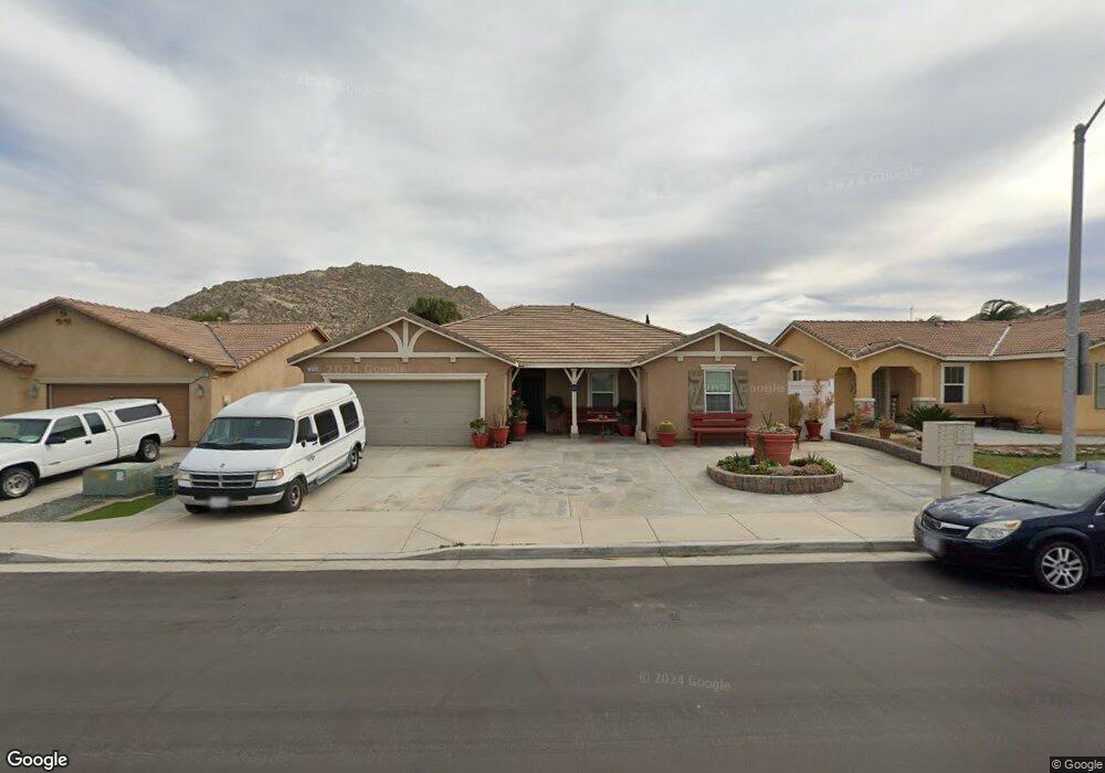
3063 Avalon Pkwy Perris, CA 92571
North Perris NeighborhoodEstimated Value: $512,731 - $557,000
4
Beds
2
Baths
1,774
Sq Ft
$302/Sq Ft
Est. Value
About This Home
This home is located at 3063 Avalon Pkwy, Perris, CA 92571 and is currently estimated at $535,183, approximately $301 per square foot. 3063 Avalon Pkwy is a home located in Riverside County with nearby schools including Sierra Vista Elementary School, Lakeside Middle School, and Rancho Verde High School.
Ownership History
Date
Name
Owned For
Owner Type
Purchase Details
Closed on
Sep 22, 2010
Sold by
Fajardo Maria F
Bought by
Fajardo Juan
Current Estimated Value
Home Financials for this Owner
Home Financials are based on the most recent Mortgage that was taken out on this home.
Original Mortgage
$161,699
Outstanding Balance
$106,449
Interest Rate
4.38%
Mortgage Type
FHA
Estimated Equity
$428,734
Create a Home Valuation Report for This Property
The Home Valuation Report is an in-depth analysis detailing your home's value as well as a comparison with similar homes in the area
Home Values in the Area
Average Home Value in this Area
Purchase History
| Date | Buyer | Sale Price | Title Company |
|---|---|---|---|
| Fajardo Juan | -- | First Amer Title Ins Co Nhs | |
| Fajardo Juan | $191,500 | First Amer Title Ins Co Nhs |
Source: Public Records
Mortgage History
| Date | Status | Borrower | Loan Amount |
|---|---|---|---|
| Open | Fajardo Juan | $161,699 |
Source: Public Records
Tax History
| Year | Tax Paid | Tax Assessment Tax Assessment Total Assessment is a certain percentage of the fair market value that is determined by local assessors to be the total taxable value of land and additions on the property. | Land | Improvement |
|---|---|---|---|---|
| 2025 | $5,267 | $244,701 | $51,239 | $193,462 |
| 2023 | $5,267 | $235,200 | $49,250 | $185,950 |
| 2022 | $5,063 | $230,589 | $48,285 | $182,304 |
| 2021 | $4,807 | $226,069 | $47,339 | $178,730 |
| 2020 | $4,770 | $223,752 | $46,854 | $176,898 |
| 2019 | $4,612 | $219,366 | $45,936 | $173,430 |
| 2018 | $4,557 | $215,066 | $45,036 | $170,030 |
| 2017 | $4,483 | $210,850 | $44,153 | $166,697 |
| 2016 | $4,469 | $206,717 | $43,288 | $163,429 |
| 2015 | $4,481 | $203,614 | $42,639 | $160,975 |
| 2014 | $4,427 | $199,627 | $41,804 | $157,823 |
Source: Public Records
Map
Nearby Homes
- 27318 Dunite Dr
- 27330 Dunite Dr
- 27354 Dunite Dr
- 27366 Dunite Dr
- 27279 Fossil Cove
- 27329 Dunite Dr
- 27315 Dunite Dr
- 27341 Dunite Dr
- 27353 Dunite Dr
- 27365 Dunite Dr
- 27379 Dunite Dr
- 1666 E Rider St
- 27322 Fossil Cove
- 27328 Fossil Cove
- 27334 Fossil Cove
- 27344 Fossil Cove
- 1752 Campanella Dr
- 27321 Fossil Cove
- 3047 Kalei Ct
- 3374 Wind Chime Ln
- 3067 Avalon Pkwy
- 3059 Avalon Pkwy
- 3064 Gazania Dr
- 3060 Gazania Dr
- 3068 Gazania Dr
- 3055 Avalon Pkwy
- 3071 Avalon Pkwy
- 3072 Gazania Dr
- 3056 Gazania Dr
- 3075 Avalon Pkwy
- 3051 Avalon Pkwy
- 3052 Gazania Dr
- 3076 Gazania Dr
- 3047 Avalon Pkwy
- 3061 Gazania Dr
- 3048 Gazania Dr
- 3065 Gazania Dr
- 3057 Gazania Dr
- 3069 Gazania Dr
- 3053 Gazania Dr
Your Personal Tour Guide
Ask me questions while you tour the home.