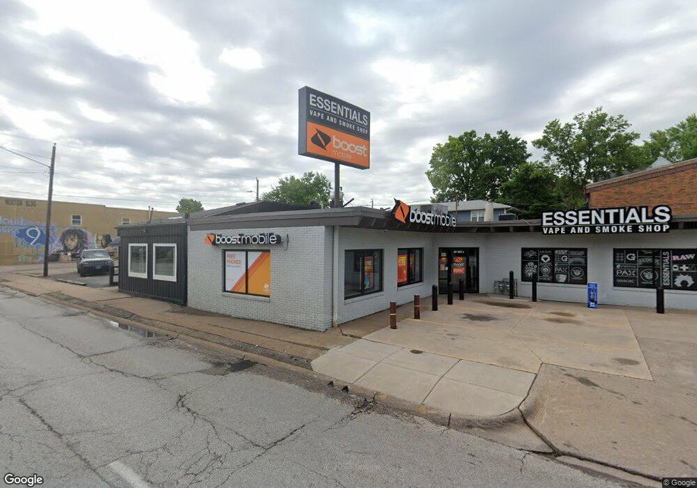
307 E Locust St Unit A Davenport, IA 52803
Central Davenport NeighborhoodEstimated Value: $140,578
--
Bed
--
Bath
2,144
Sq Ft
$66/Sq Ft
Est. Value
About This Home
This home is located at 307 E Locust St Unit A, Davenport, IA 52803 and is currently estimated at $140,578, approximately $65 per square foot. 307 E Locust St Unit A is a home located in Scott County with nearby schools including Crofton Elementary School, Christian County Day Treatment Center Alt, and Casey County Middle School.
Ownership History
Date
Name
Owned For
Owner Type
Purchase Details
Closed on
Dec 19, 2007
Sold by
Burke Vincent D and Martinoff Burke Joan
Bought by
Mogul Holdings L L C
Current Estimated Value
Home Financials for this Owner
Home Financials are based on the most recent Mortgage that was taken out on this home.
Original Mortgage
$75,000
Outstanding Balance
$47,053
Interest Rate
6.13%
Mortgage Type
Future Advance Clause Open End Mortgage
Estimated Equity
$94,181
Create a Home Valuation Report for This Property
The Home Valuation Report is an in-depth analysis detailing your home's value as well as a comparison with similar homes in the area
Home Values in the Area
Average Home Value in this Area
Purchase History
| Date | Buyer | Sale Price | Title Company |
|---|---|---|---|
| Mogul Holdings L L C | $75,000 | None Available | |
| Mogul Holdings L L C | $75,000 | None Available |
Source: Public Records
Mortgage History
| Date | Status | Borrower | Loan Amount |
|---|---|---|---|
| Open | Mogul Holdings L L C | $75,000 |
Source: Public Records
Tax History Compared to Growth
Tax History
| Year | Tax Paid | Tax Assessment Tax Assessment Total Assessment is a certain percentage of the fair market value that is determined by local assessors to be the total taxable value of land and additions on the property. | Land | Improvement |
|---|---|---|---|---|
| 2025 | $3,096 | $169,190 | $28,150 | $141,040 |
| 2024 | $4,107 | $159,960 | $28,150 | $131,810 |
| 2023 | $2,880 | $192,910 | $28,150 | $164,760 |
| 2022 | $2,914 | $131,360 | $28,150 | $103,210 |
| 2021 | $2,818 | $131,360 | $28,150 | $103,210 |
| 2020 | $2,584 | $118,980 | $28,150 | $90,830 |
| 2019 | $2,484 | $110,720 | $28,150 | $82,570 |
| 2018 | $2,432 | $110,720 | $28,150 | $82,570 |
| 2017 | $996 | $110,720 | $28,150 | $82,570 |
| 2016 | $2,910 | $132,900 | $0 | $0 |
| 2015 | $2,910 | $132,900 | $0 | $0 |
| 2014 | $2,952 | $132,900 | $0 | $0 |
| 2013 | $4,096 | $0 | $0 | $0 |
| 2012 | -- | $132,900 | $44,200 | $88,700 |
Source: Public Records
Map
Nearby Homes
- 1812 Pershing Ave
- 125 E Locust St
- 325 Kirkwood Blvd
- 420 Kirkwood Blvd
- 511 Kirkwood Blvd
- 320 E 14th St
- 618 Douglas Ct
- 1518 N Main St
- 407 E 14th St
- 409 E 14th St
- 1605 N Harrison St
- 625 E High St
- 209 E 13th St
- 1222 Pershing Ave
- 224 E Rusholme St
- 402 E Rusholme St
- 637 E 15th St
- 2211 Farnam St
- 2307 Farnam St
- 325 E Dover Ct
- 307 E Locust St
- 307 E Locust St Unit B
- 229 E Locust St
- 1811 Pershing Ave
- 1816 Pershing Ave
- 1816 Pershing Ave Unit 2
- 1816 Pershing Ave Unit 1/2
- 1816-1816 1/2 Pershing St
- 250 E Locust St
- 225 E Locust St
- 1801 Pershing Ave
- 1907 Pershing Ave
- 1804 Pershing Ave
- 1812 Iowa St
- 1725 Pershing Ave
- 1808 Iowa St
- 1916 Pershing Ave
- 224 E 18th St
- 1905 Virginia Ave
- 328 E Locust St