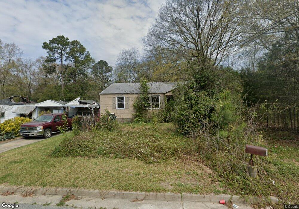
3079 Rice Cir Macon, GA 31204
Estimated Value: $45,000 - $60,000
2
Beds
1
Bath
910
Sq Ft
$59/Sq Ft
Est. Value
About This Home
This home is located at 3079 Rice Cir, Macon, GA 31204 and is currently estimated at $53,242, approximately $58 per square foot. 3079 Rice Cir is a home located in Bibb County with nearby schools including Weaver Middle School, Westside High School, and Cirrus Charter Academy.
Ownership History
Date
Name
Owned For
Owner Type
Purchase Details
Closed on
Oct 30, 2016
Bought by
Huizache Gudelia
Current Estimated Value
Purchase Details
Closed on
May 5, 2016
Sold by
Winhard Properties Llc
Bought by
Property Conveyors Llc
Purchase Details
Closed on
Mar 7, 2014
Sold by
Bryant Brad and Bryant Ray
Bought by
Winhard Properties Llc
Purchase Details
Closed on
May 28, 1998
Sold by
Scarbrough Samuel N Etals
Bought by
Bryant Brad and Bryant Ray
Create a Home Valuation Report for This Property
The Home Valuation Report is an in-depth analysis detailing your home's value as well as a comparison with similar homes in the area
Purchase History
We collect this data history from publicly available records. To have your information removed, we recommend requesting removal directly through your county’s website.
| Date | Buyer | Sale Price | Title Company |
|---|---|---|---|
| Huizache Gudelia | $2,000 | -- | |
| Property Conveyors Llc | $60,650 | -- | |
| Winhard Properties Llc | $60,000 | -- | |
| Bryant Brad | $135,000 | -- |
Source: Public Records
Tax History
| Year | Tax Paid | Tax Assessment Tax Assessment Total Assessment is a certain percentage of the fair market value that is determined by local assessors to be the total taxable value of land and additions on the property. | Land | Improvement |
|---|---|---|---|---|
| 2025 | $299 | $12,186 | $2,160 | $10,026 |
| 2024 | $287 | $11,285 | $2,160 | $9,125 |
| 2023 | $287 | $11,285 | $2,160 | $9,125 |
| 2022 | $231 | $6,668 | $1,696 | $4,972 |
| 2021 | $253 | $6,668 | $1,696 | $4,972 |
| 2020 | $259 | $6,668 | $1,696 | $4,972 |
| 2019 | $261 | $6,668 | $1,696 | $4,972 |
| 2018 | $506 | $5,438 | $1,696 | $3,742 |
| 2017 | $30 | $5,438 | $1,696 | $3,742 |
| 2016 | $352 | $10,171 | $1,696 | $8,475 |
| 2015 | $82 | $10,171 | $1,696 | $8,475 |
| 2014 | $568 | $10,092 | $1,696 | $8,396 |
Source: Public Records
Map
Nearby Homes
- 1046 Radio Dr
- 1405 Bailey Ave
- 0 Macon Ave Unit 25970106
- 2877 Ellis South Evans State Road St
- 1425 Bailey Ave
- 1425 Bailey Ave Unit 3
- 1422 Helon St
- 966 Wilmar Dr
- 1219 Burton Ave
- 1195 Brentwood Ave
- 1470 Bankston Ave
- 1463 Bankston Ave
- 3045 Montpelier Place
- 3069 Montpelier Place
- 1076 Crescent Ave
- 1463 Berkner Ave
- 1487 Brentwood Ave
- 1242 Winton Ave
- 1516 Berkner Ave
- 3105 Saint Claire St
- 3089 Rice Cir
- 3095 Rice Cir
- 3098 Rice Cir
- 1171 Bailey Ave
- 3088 Rice Cir
- 3080 Rice Cir
- 3096 Rice Cir
- 3084 Rice Cir
- 3086 Rice Cir
- 1213 Rice Place
- 1228 Rice Place
- 1227 Bailey Ave
- 1180 Bailey Ave
- 1230 Rice Place
- 1192 Bailey Ave
- 1215 Rice Place
- 1208 Bailey Ave
- 1184 Bailey Ave
- 1180 Bailey Ave
- 1072 Nassau Place
Your Personal Tour Guide
Ask me questions while you tour the home.