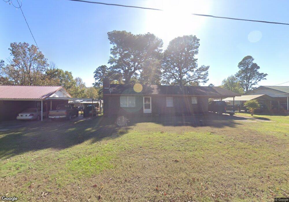
308 E Memorial St Broken Bow, OK 74728
Estimated Value: $129,039 - $185,000
3
Beds
1
Bath
1,188
Sq Ft
$128/Sq Ft
Est. Value
About This Home
This home is located at 308 E Memorial St, Broken Bow, OK 74728 and is currently estimated at $152,510, approximately $128 per square foot. 308 E Memorial St is a home located in McCurtain County with nearby schools including Dierks Elementary School, Bennett Elementary School, and Rector Johnson Middle School.
Ownership History
Date
Name
Owned For
Owner Type
Purchase Details
Closed on
Aug 17, 2005
Sold by
Camp James Guy and Camp Amanda D
Bought by
Pennington Jim
Current Estimated Value
Home Financials for this Owner
Home Financials are based on the most recent Mortgage that was taken out on this home.
Original Mortgage
$59,000
Interest Rate
5.65%
Mortgage Type
New Conventional
Purchase Details
Closed on
Jul 29, 2002
Sold by
Smith Helen
Bought by
Camp James and Camp Amanda
Purchase Details
Closed on
Jun 21, 1993
Sold by
Turley Wylie E
Bought by
Smith Helen
Create a Home Valuation Report for This Property
The Home Valuation Report is an in-depth analysis detailing your home's value as well as a comparison with similar homes in the area
Home Values in the Area
Average Home Value in this Area
Purchase History
| Date | Buyer | Sale Price | Title Company |
|---|---|---|---|
| Pennington Jim | $65,000 | First American Title Insuran | |
| Camp James | $26,500 | -- | |
| Smith Helen | -- | -- |
Source: Public Records
Mortgage History
| Date | Status | Borrower | Loan Amount |
|---|---|---|---|
| Closed | Pennington Jim | $59,000 |
Source: Public Records
Tax History Compared to Growth
Tax History
| Year | Tax Paid | Tax Assessment Tax Assessment Total Assessment is a certain percentage of the fair market value that is determined by local assessors to be the total taxable value of land and additions on the property. | Land | Improvement |
|---|---|---|---|---|
| 2024 | $517 | $7,208 | $369 | $6,839 |
| 2023 | $491 | $6,998 | $369 | $6,629 |
| 2022 | $475 | $6,795 | $369 | $6,426 |
| 2021 | $467 | $6,795 | $369 | $6,426 |
| 2020 | $484 | $6,952 | $369 | $6,583 |
| 2019 | $486 | $6,952 | $369 | $6,583 |
| 2018 | $504 | $7,108 | $369 | $6,739 |
| 2017 | $521 | $7,265 | $369 | $6,896 |
| 2016 | $516 | $7,150 | $369 | $6,781 |
| 2015 | $528 | $7,150 | $369 | $6,781 |
| 2014 | $531 | $7,150 | $369 | $6,781 |
Source: Public Records
Map
Nearby Homes
- 309 E Memorial St
- 81 Annie Oak Trail
- 113 Highmeadow Cir
- 1200 Kuykendall Rd
- 025 Kuykendall Rd
- 011 Kuykendall Rd
- 010 Kuykendall Rd
- 008 Kuykendall Rd
- 009 Kuykendall Rd
- 005 Kuykendall Rd
- 006 Kuykendall Rd
- 007 Kuykendall Rd
- 004 Kuykendall Rd
- 003 Kuykendall Rd
- 001 Kuykendall Rd
- 11 Kuykendall Rd
- 10 Kuykendall Rd
- 09 Kuykendall Rd
- 08 Kuykendall Rd
- 07 Kuykendall Rd
- 310 E Memorial St
- 306 E Memorial St
- 114 Esplanade Dr
- 304 E Memorial St
- 305 E Memorial St
- 102 Esplanade Dr
- 111 Esplanade Dr
- 302 E Memorial St
- 302 E Memorial St
- 104 Esplanade Dr
- 401 E Memorial St
- 103 Esplanade Dr
- 101 Esplanade Dr
- 304 Dogwood Ct
- 300 E Memorial St
- 401 1/2 E Memorial St
- 105 Esplanade Dr
- 305 Dogwood Ct
- 210 E Memorial St
- 107 Esplanade Dr