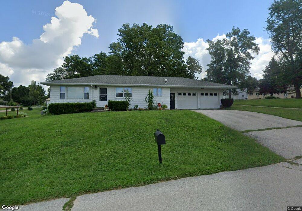
308 N 10th St Dunlap, IA 51529
Estimated Value: $141,000 - $208,000
3
Beds
2
Baths
1,092
Sq Ft
$153/Sq Ft
Est. Value
About This Home
This home is located at 308 N 10th St, Dunlap, IA 51529 and is currently estimated at $167,343, approximately $153 per square foot. 308 N 10th St is a home located in Harrison County with nearby schools including Boyer Valley Elementary School and Boyer Valley Middle/High School.
Ownership History
Date
Name
Owned For
Owner Type
Purchase Details
Closed on
May 30, 2014
Sold by
Fouts Anita and Hawes Bonnie
Bought by
Buresh Robert W and Buresh Shelly L
Current Estimated Value
Home Financials for this Owner
Home Financials are based on the most recent Mortgage that was taken out on this home.
Original Mortgage
$75,000
Outstanding Balance
$57,180
Interest Rate
4.34%
Mortgage Type
Future Advance Clause Open End Mortgage
Estimated Equity
$110,163
Create a Home Valuation Report for This Property
The Home Valuation Report is an in-depth analysis detailing your home's value as well as a comparison with similar homes in the area
Home Values in the Area
Average Home Value in this Area
Purchase History
| Date | Buyer | Sale Price | Title Company |
|---|---|---|---|
| Buresh Robert W | $85,000 | None Available |
Source: Public Records
Mortgage History
| Date | Status | Borrower | Loan Amount |
|---|---|---|---|
| Open | Buresh Robert W | $75,000 |
Source: Public Records
Tax History Compared to Growth
Tax History
| Year | Tax Paid | Tax Assessment Tax Assessment Total Assessment is a certain percentage of the fair market value that is determined by local assessors to be the total taxable value of land and additions on the property. | Land | Improvement |
|---|---|---|---|---|
| 2025 | $2,246 | $148,370 | $11,970 | $136,400 |
| 2024 | $2,246 | $134,920 | $11,970 | $122,950 |
| 2023 | $2,154 | $134,920 | $11,970 | $122,950 |
| 2022 | $2,068 | $117,087 | $11,970 | $105,117 |
| 2021 | $2,068 | $117,087 | $11,970 | $105,117 |
| 2020 | $1,844 | $100,028 | $11,970 | $88,058 |
| 2019 | $1,872 | $100,028 | $11,970 | $88,058 |
| 2018 | $1,858 | $95,487 | $0 | $0 |
| 2017 | $1,914 | $95,487 | $0 | $0 |
| 2016 | $1,886 | $95,487 | $0 | $0 |
| 2015 | $1,886 | $86,024 | $0 | $0 |
| 2014 | $1,754 | $86,024 | $0 | $0 |
Source: Public Records
Map
Nearby Homes
- 1403 Eaton St
- 202 Y St
- 32055 Spruce Ave
- 1110 Street F16
- 2074 U Ave
- 211 Brookview Dr
- 2590 220th St
- 37 10th St
- 808 Park St
- 42 6th St
- 406 Weare St
- 102 Bluegrass Ln
- 101 Bluegrass Ln
- 907 Harvest Hills Dr
- 106 Bluegrass Ln
- 905 Harvest Hills Dr
- 903 Harvest Hills Dr
- 111 Ridgeline Rd
- 906 Harvest Hills Dr
- 305 Normal St
- 1006 Clinton St
- 1002 Clinton St
- 1001 Montague St
- 311 N 10th St
- 1005 Montague St
- 305 N 10th St
- 307 N 11th St
- 1007 Montague St
- 906 Clinton St
- 909 Montague St
- 1009 Montague St
- 905 Montague St
- 1001 Clinton St
- 1003 Clinton St
- 1005 Clinton St
- 1007 Clinton St
- 401 N 11th St
- 401 N 11th St Unit Q
- 1002 Montague St
- 306 N 9th St