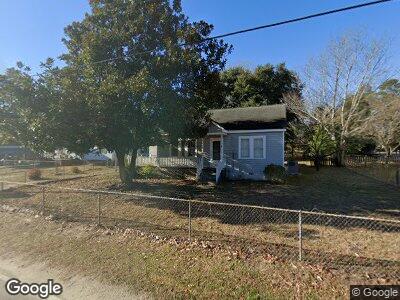
309 Hook Ave West Columbia, SC 29169
Estimated Value: $158,789 - $212,000
2
Beds
1
Bath
1,180
Sq Ft
$152/Sq Ft
Est. Value
About This Home
This home is located at 309 Hook Ave, West Columbia, SC 29169 and is currently estimated at $179,447, approximately $152 per square foot. 309 Hook Ave is a home located in Lexington County with nearby schools including Riverbank Elementary, Northside Middle, and Brookland-Cayce High School.
Ownership History
Date
Name
Owned For
Owner Type
Purchase Details
Closed on
Oct 11, 2023
Sold by
Wooten Benjamin Matthew
Bought by
Wooten Benjamin Matthew
Current Estimated Value
Purchase Details
Closed on
Jul 27, 2022
Sold by
Bouknight Wooten Darlene
Bought by
Wooten Sarah Melissa and Wooten Meredith Ann
Purchase Details
Closed on
Dec 15, 2020
Sold by
Wooten Sarah and Estate Of John Timothy Wooten
Bought by
Estate Of Darlene Bonknight Wooten
Purchase Details
Closed on
Mar 26, 2020
Sold by
Marshall Rebecca Wooten and Wooten Thresa Roxanne
Bought by
Wooten Benjamin Matthew
Purchase Details
Closed on
Sep 5, 2018
Sold by
Brown Karen Wooten
Bought by
Wooten John Timothy
Purchase Details
Closed on
May 20, 2010
Sold by
Estate Of Lucille M Wooten and Wooten Roxanne
Bought by
Marshall Rebecca Wooten and Wooten Thresa Roxanne
Create a Home Valuation Report for This Property
The Home Valuation Report is an in-depth analysis detailing your home's value as well as a comparison with similar homes in the area
Home Values in the Area
Average Home Value in this Area
Purchase History
| Date | Buyer | Sale Price | Title Company |
|---|---|---|---|
| Wooten Benjamin Matthew | -- | None Listed On Document | |
| Wooten Sarah Melissa | -- | None Listed On Document | |
| Estate Of Darlene Bonknight Wooten | -- | None Available | |
| Wooten Benjamin Matthew | -- | None Available | |
| Wooten John Timothy | -- | None Available | |
| Marshall Rebecca Wooten | -- | -- |
Source: Public Records
Tax History Compared to Growth
Tax History
| Year | Tax Paid | Tax Assessment Tax Assessment Total Assessment is a certain percentage of the fair market value that is determined by local assessors to be the total taxable value of land and additions on the property. | Land | Improvement |
|---|---|---|---|---|
| 2024 | $657 | $3,442 | $1,120 | $2,322 |
| 2023 | $657 | $5,163 | $1,680 | $3,483 |
| 2022 | $1,929 | $5,163 | $1,680 | $3,483 |
| 2020 | $1,829 | $5,163 | $1,680 | $3,483 |
| 2019 | $1,841 | $4,985 | $1,578 | $3,407 |
| 2018 | $1,603 | $4,741 | $1,504 | $3,237 |
| 2017 | $1,571 | $4,741 | $1,504 | $3,237 |
| 2016 | $1,591 | $4,739 | $1,504 | $3,235 |
| 2014 | $1,369 | $4,715 | $1,500 | $3,215 |
| 2013 | -- | $4,720 | $1,500 | $3,220 |
Source: Public Records
Map
Nearby Homes
- 203 Woodhaven Dr
- 0 Platt Springs Rd Unit 606355
- 0 Platt Springs Rd Unit 605298
- 1 Janice Faye Trail
- 623 Hook Ave
- 213 Greenwood Rd
- 258 Gum Swamp Trail
- 159 Alexandria St
- 348 Gum Swamp Trail
- 217 Congaree Mill Ln
- 139 Silver Run Place
- 141 Silver Run Place
- 175 Silver Run Place
- 2107 Klapman Rd
- 146 Sabal Dr
- 212 Alexandria St
- 154 Manning Dr
- 217 Alexandria St
- 1513 Gambrell St
- 224 17th St