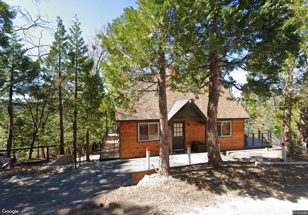
309 Summit Dr Lake Arrowhead, CA 92352
Estimated Value: $428,000 - $845,000
3
Beds
2
Baths
--
Sq Ft
--
Built
About This Home
This home is located at 309 Summit Dr, Lake Arrowhead, CA 92352 and is currently estimated at $590,932. 309 Summit Dr is a home located in San Bernardino County with nearby schools including Lake Arrowhead Elementary School, Mary P. Henck Intermediate School, and Rim Of The World Senior High School.
Ownership History
Date
Name
Owned For
Owner Type
Purchase Details
Closed on
Apr 4, 2011
Sold by
Baker Robert J
Bought by
May Patrick and May Michelle
Current Estimated Value
Purchase Details
Closed on
Nov 10, 2009
Sold by
Whitmore Linda S and Harrison Sandra L
Bought by
Baker Alice and Baker Robert J
Purchase Details
Closed on
Mar 19, 2009
Sold by
Whitmore Linda S and Harrison Sandra L
Bought by
Whitmore Linda S and Harrison Sandra L
Purchase Details
Closed on
Oct 10, 1994
Sold by
Foley Perez Adrian and Foley Perez Deborah
Bought by
Foley Edgar and Foley Patricia
Create a Home Valuation Report for This Property
The Home Valuation Report is an in-depth analysis detailing your home's value as well as a comparison with similar homes in the area
Home Values in the Area
Average Home Value in this Area
Purchase History
| Date | Buyer | Sale Price | Title Company |
|---|---|---|---|
| May Patrick | $245,000 | First American Title Company | |
| Baker Alice | $130,000 | Chicago Title Company | |
| Whitmore Linda S | -- | None Available | |
| Foley Edgar | $8,000 | North American Title |
Source: Public Records
Tax History
| Year | Tax Paid | Tax Assessment Tax Assessment Total Assessment is a certain percentage of the fair market value that is determined by local assessors to be the total taxable value of land and additions on the property. | Land | Improvement |
|---|---|---|---|---|
| 2025 | $3,379 | $275,453 | $51,247 | $224,206 |
| 2024 | $3,025 | $252,687 | $50,242 | $202,445 |
| 2023 | $3,175 | $247,734 | $49,257 | $198,477 |
| 2022 | $3,112 | $259,567 | $48,291 | $211,276 |
| 2021 | $3,077 | $254,477 | $47,344 | $207,133 |
| 2020 | $3,076 | $251,868 | $46,859 | $205,009 |
| 2019 | $3,000 | $246,929 | $45,940 | $200,989 |
| 2018 | $3,018 | $242,087 | $45,039 | $197,048 |
| 2017 | $2,968 | $237,340 | $44,156 | $193,184 |
| 2016 | $2,915 | $232,686 | $43,290 | $189,396 |
| 2015 | $2,891 | $229,191 | $42,640 | $186,551 |
| 2014 | $2,845 | $224,702 | $41,805 | $182,897 |
Source: Public Records
Map
Nearby Homes
- 305 Summit Rd
- 329 Summit Rd
- 0 Terrace Rd Unit 32500984
- 0 Terrace Rd Unit IG25091707
- 197 Rocky Point Rd
- 27500 Highway 189 Unit 83
- 27500 Highway 189 Unit 36
- 27844 Greenway Dr
- 27500 California 189
- 27500 California 189 Unit 81
- 27828 Rainbow Dr
- 27346 N Bay Rd
- 551 Raccoon Ct
- 27961 Rainbow Dr
- 244 Corona Cir
- 27981 Lakes Edge Rd
- 226 Holiday Dr
- 252 Crest Circle Dr
- 0 Cottage Grove Rd Unit RW24137503
- 27409 N Bay Rd
- 320 Castle Gate Rd
- 300 Castle Gate Rd
- 313 Summit Rd Unit N
- 313 Summit Rd
- 369 Summit Dr
- 324 Castle Gate Rd
- 314 Castle Gate Rd
- 307 Castle Gate Rd
- 366 Summit Dr
- 305 Castle Gate Rd
- 317 Summit Dr
- 365 Summit Dr
- 317 Castle Gate Rd
- 320 Burnt Mill Rd
- 266 Terrace Rd
- 316 Burnt Mill Rd
- 361 Summit Dr
- 297 Burnt Mill Rd
- 360 Summit Rd
- 329 Castle Gate Rd
Your Personal Tour Guide
Ask me questions while you tour the home.