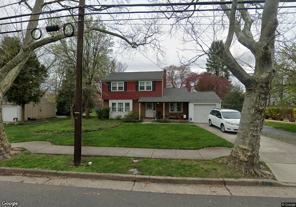
309 W 3rd St Moorestown, NJ 08057
Estimated Value: $399,145 - $658,000
--
Bed
--
Bath
1,678
Sq Ft
$318/Sq Ft
Est. Value
About This Home
This home is located at 309 W 3rd St, Moorestown, NJ 08057 and is currently estimated at $533,786, approximately $318 per square foot. 309 W 3rd St is a home located in Burlington County with nearby schools including George C. Baker Elementary School, Moorestown Upper Elementary School, and William Allen Middle School.
Ownership History
Date
Name
Owned For
Owner Type
Purchase Details
Closed on
Sep 15, 2021
Sold by
Mitchell Suzanne and Revocable Trust Of M Lindsay M
Bought by
Mitchell M Lindsay and Revocable Trust Of M Lindsay M
Current Estimated Value
Purchase Details
Closed on
May 15, 2018
Sold by
Michell Mauric L
Bought by
Mitchell Suznane and Lindsay Mitchell M
Purchase Details
Closed on
Sep 23, 1992
Bought by
Mitchell Maurice L
Create a Home Valuation Report for This Property
The Home Valuation Report is an in-depth analysis detailing your home's value as well as a comparison with similar homes in the area
Home Values in the Area
Average Home Value in this Area
Purchase History
| Date | Buyer | Sale Price | Title Company |
|---|---|---|---|
| Mitchell M Lindsay | -- | None Available | |
| Mitchell Suznane | -- | None Available | |
| Mitchell Maurice L | -- | -- |
Source: Public Records
Tax History Compared to Growth
Tax History
| Year | Tax Paid | Tax Assessment Tax Assessment Total Assessment is a certain percentage of the fair market value that is determined by local assessors to be the total taxable value of land and additions on the property. | Land | Improvement |
|---|---|---|---|---|
| 2025 | $6,531 | $230,200 | $120,200 | $110,000 |
| 2024 | $6,333 | $230,200 | $120,200 | $110,000 |
| 2023 | $6,333 | $230,200 | $120,200 | $110,000 |
| 2022 | $6,268 | $230,200 | $120,200 | $110,000 |
| 2021 | $4,632 | $230,200 | $120,200 | $110,000 |
| 2020 | $6,146 | $230,200 | $120,200 | $110,000 |
| 2019 | $6,038 | $230,200 | $120,200 | $110,000 |
| 2018 | $5,875 | $230,200 | $120,200 | $110,000 |
| 2017 | $5,925 | $230,200 | $120,200 | $110,000 |
| 2016 | $5,905 | $230,200 | $120,200 | $110,000 |
| 2015 | $5,833 | $230,200 | $120,200 | $110,000 |
| 2014 | $5,539 | $230,200 | $120,200 | $110,000 |
Source: Public Records
Map
Nearby Homes
- 313 Fairview Ave
- 493 N Church St
- 420 Park Blvd
- 4 W Close
- 10 E Close Unit 10EAST
- 129 S Church St
- 316 Farmdale Rd
- 5 Collins Mill Ct
- 8 Collins Mill Ct
- 18 S Close Unit 18
- 543 Bethel Ave
- 559 N Church St
- 15 E 2nd St
- 601 Stratford Dr
- 602 Windsor Place
- 8 E Oak Ave
- 1 Circle Dr
- 310 S Washington Ave
- 50 E 3rd St
- 430 Highland Dr