Estimated Value: $307,090 - $332,000
--
Bed
3
Baths
1,891
Sq Ft
$171/Sq Ft
Est. Value
About This Home
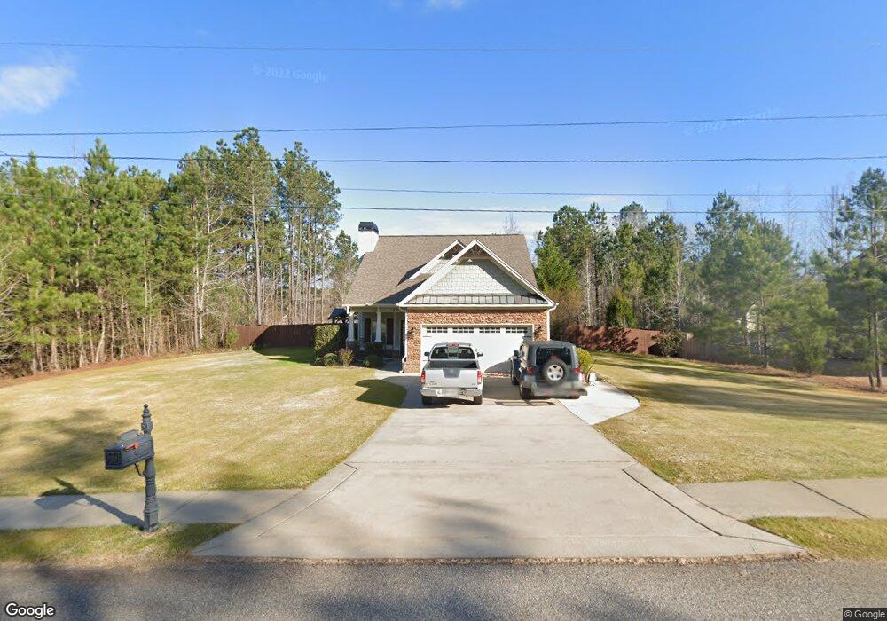
This home is located at 309 Walnut Grove Rd, Gray, GA 31032 and is currently estimated at $323,523, approximately $171 per square foot. 309 Walnut Grove Rd is a home with nearby schools including Turner Woods Elementary School, Gray Station Middle School, and Jones County High School.
Ownership History
Date
Name
Owned For
Owner Type
Purchase Details
Closed on
Nov 23, 2011
Sold by
Dames Ferry Communities
Bought by
Burt Arthur Gilbert
Current Estimated Value
Home Financials for this Owner
Home Financials are based on the most recent Mortgage that was taken out on this home.
Original Mortgage
$153,000
Outstanding Balance
$104,984
Interest Rate
4.15%
Mortgage Type
New Conventional
Estimated Equity
$218,539
Purchase Details
Closed on
Jun 5, 2007
Sold by
Not Provided
Bought by
Dames Ferry Communities Llc
Create a Home Valuation Report for This Property
The Home Valuation Report is an in-depth analysis detailing your home's value as well as a comparison with similar homes in the area
Home Values in the Area
Average Home Value in this Area
Purchase History
| Date | Buyer | Sale Price | Title Company |
|---|---|---|---|
| Burt Arthur Gilbert | $170,000 | -- | |
| Dames Ferry Communities Llc | $392,000 | -- | |
| Dames Ferry Communities Llc | $332,500 | -- |
Source: Public Records
Mortgage History
| Date | Status | Borrower | Loan Amount |
|---|---|---|---|
| Open | Burt Arthur Gilbert | $153,000 |
Source: Public Records
Tax History Compared to Growth
Tax History
| Year | Tax Paid | Tax Assessment Tax Assessment Total Assessment is a certain percentage of the fair market value that is determined by local assessors to be the total taxable value of land and additions on the property. | Land | Improvement |
|---|---|---|---|---|
| 2023 | $3,115 | $90,398 | $8,000 | $82,398 |
| 2022 | $3,115 | $90,398 | $8,000 | $82,398 |
| 2021 | $2,936 | $85,349 | $6,000 | $79,349 |
| 2020 | $2,606 | $76,128 | $6,000 | $70,128 |
| 2019 | $2,606 | $76,128 | $6,000 | $70,128 |
| 2018 | $2,563 | $74,928 | $4,800 | $70,128 |
| 2017 | $2,563 | $74,928 | $4,800 | $70,128 |
| 2016 | $2,563 | $74,928 | $4,800 | $70,128 |
| 2015 | $2,421 | $74,928 | $4,800 | $70,128 |
| 2014 | $2,257 | $75,635 | $4,800 | $70,835 |
Source: Public Records
Map
Nearby Homes
- 140 Lite-N-tie Rd
- 229 Lite N Tie Rd
- 664 Aarons Cir
- 00 Hidden Hills Ct
- 0 Clinton Crossing Dr Unit M181966
- 146 Lite N Tie Rd
- 250 Stone Brooke Dr Unit LOT 133
- 250 Stone Brooke Dr
- 266 Clinton Crossing Dr
- 0 Clinton Crossing Unit 10637924
- 151 Stone Brooke Dr
- 151 Stone Brooke Dr Unit LOT 5
- Bedford Plan at Stone Brooke
- Auburn Plan at Stone Brooke
- Franklin Plan at Stone Brooke
- Peachwood Plan at Stone Brooke
- Woodbury Plan at Stone Brooke
- LOT 1 C Georgia 18
- 1023 Boulder Dr Unit LOT 65
- 1023 Boulder Dr
- 313 Walnut Grove Rd
- 327 Walnut Grove Rd
- 321 Walnut Grove Rd
- 333 Walnut Grove Rd
- 310 Twins Lakes Dr
- 310 Twin Lakes Dr
- 317 Walnut Grove Rd
- 304 Twin Lakes Dr
- 306 Walnut Grove Rd
- 310 Walnut Grove Rd
- 314 Twin Lakes Dr
- 318 Twin Lakes Dr
- 294 Lite N Tie Rd
- 284 Lite N Tie Rd
- 284 Lite N Tie Rd
- 284 Lite-N-tie Rd
- 0 Lite-N-tie Rd Unit 8307092
- 146 Lite-N-tie Rd
- 1134 Lite-N-tie Rd
- 324 Walnut Grove Rd