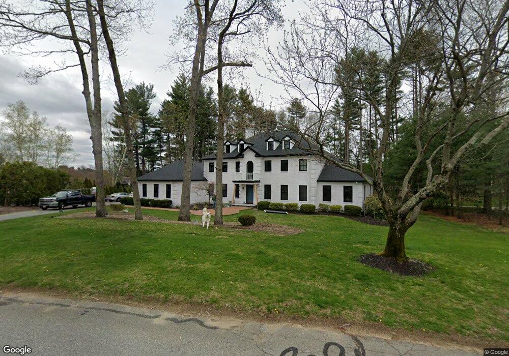
31 Alford Cir Concord, MA 01742
Estimated Value: $2,938,189 - $3,446,000
5
Beds
5
Baths
6,274
Sq Ft
$519/Sq Ft
Est. Value
About This Home
This home is located at 31 Alford Cir, Concord, MA 01742 and is currently estimated at $3,256,297, approximately $519 per square foot. 31 Alford Cir is a home located in Middlesex County with nearby schools including Willard School, Concord Middle School, and Concord Academy.
Ownership History
Date
Name
Owned For
Owner Type
Purchase Details
Closed on
Jun 29, 2018
Sold by
Obrien Michael W and Obrien Andrea Obrien
Bought by
Scanio Michael V and Scanio Lauren
Current Estimated Value
Home Financials for this Owner
Home Financials are based on the most recent Mortgage that was taken out on this home.
Original Mortgage
$1,340,000
Outstanding Balance
$1,134,204
Interest Rate
3.5%
Mortgage Type
Unknown
Estimated Equity
$2,122,093
Purchase Details
Closed on
Jul 9, 1997
Sold by
Devine Daniel E and Devine Pamela J
Bought by
Obrien Michael W and Andrea Obrien L
Home Financials for this Owner
Home Financials are based on the most recent Mortgage that was taken out on this home.
Original Mortgage
$750,000
Interest Rate
7.56%
Create a Home Valuation Report for This Property
The Home Valuation Report is an in-depth analysis detailing your home's value as well as a comparison with similar homes in the area
Home Values in the Area
Average Home Value in this Area
Purchase History
| Date | Buyer | Sale Price | Title Company |
|---|---|---|---|
| Scanio Michael V | $1,675,000 | -- | |
| Obrien Michael W | $1,042,500 | -- |
Source: Public Records
Mortgage History
| Date | Status | Borrower | Loan Amount |
|---|---|---|---|
| Open | Scanio Michael V | $1,340,000 | |
| Previous Owner | Obrien Michael W | $750,000 | |
| Previous Owner | Obrien Michael W | $750,000 | |
| Previous Owner | Obrien Michael W | $25,000 |
Source: Public Records
Tax History Compared to Growth
Tax History
| Year | Tax Paid | Tax Assessment Tax Assessment Total Assessment is a certain percentage of the fair market value that is determined by local assessors to be the total taxable value of land and additions on the property. | Land | Improvement |
|---|---|---|---|---|
| 2025 | $332 | $2,501,000 | $578,400 | $1,922,600 |
| 2024 | $32,498 | $2,475,100 | $578,400 | $1,896,700 |
| 2023 | $26,278 | $2,027,600 | $525,700 | $1,501,900 |
| 2022 | $23,899 | $1,619,200 | $374,900 | $1,244,300 |
| 2021 | $22,600 | $1,535,300 | $409,000 | $1,126,300 |
| 2020 | $22,257 | $1,564,100 | $409,000 | $1,155,100 |
| 2019 | $20,544 | $1,447,800 | $380,300 | $1,067,500 |
| 2018 | $20,370 | $1,425,500 | $372,600 | $1,052,900 |
| 2017 | $20,314 | $1,443,800 | $355,000 | $1,088,800 |
| 2016 | $20,897 | $1,501,200 | $395,000 | $1,106,200 |
| 2015 | $19,700 | $1,378,600 | $365,900 | $1,012,700 |
Source: Public Records
Map
Nearby Homes
- 37 Wolf Pine Way
- 497 Old Road to 9 Acre Corner
- 40 Rookery Ln Unit 5
- 72 Rookery Ln Unit 3
- 24 Rookery Ln Unit 6
- 56 Rookery Ln Unit 4
- 121 White Pond Way Unit 121
- 12 S Meadow Ridge Unit 12
- 12 S Meadow Ridge
- 114 Upland Rd
- 401 Emery Ln Unit 304
- 111 Central St
- 1053 Main St
- 24 Concord Greene Unit 7
- 70 McCallar Ln
- 29 Concord Greene Unit 3
- 16 Concord Greene Unit 5
- 102 Highland St
- 42 Dakin Rd
- 236 Fairhaven Rd
- 27 Alford Cir
- 80 Alford Cir
- 26 Alford Cir
- 145 Mattison Dr
- 70 Alford Cir
- 156 Mattison Dr
- 121 Mattison Dr
- 14B Mattison Dr
- 66 Alford Cir
- 200 Mattison Dr
- 195 Mattison Dr
- 105 Mattison Dr
- 98 Peter Bulkeley Rd
- 203 Mattison Dr
- 205 Mattison Dr
- 89 Mattison Dr
- 91 Peter Bulkeley Rd
- 110 Mattison Dr
- 110 Mattison Dr Unit 110
- 240 Mattison Dr